Sold2022Antique Map Print - Map of Hesja-Nassau - Map of Austria - Prussian ProvinceAntique outline hand colored map from edition of Meyer’s world atlas, edited by Ludwig Ravenstein, published by Bibliographic Institute in 1872. Technique: Engraving. Place: Leipzig, Germany. SSee Sold Price
Sold2016Map of Bermuda, by Hondius 1633Map of Bermuda, by Hondius 1633. Original hand colored copper engraving. Showing the "tribes" that were granted by the gentleman onboard the shipwreck that force the European settlement of the island.See Sold Price
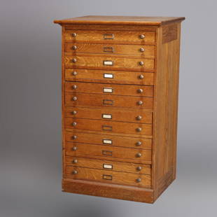
Sold2020Eight Drawer Oak Map, Art or Print File Cabinet, C 1910An antique map, art or print fining cabinet offers oak construction with eight drawers, brass pulls throughout, c1910. Measures- 45.5" H x 28" W x 22.75" D. ***IN-HOUSE SHIPPING & DELIVERY QUICK QUOTESee Sold Price
Sold2017ANTIQUE MAP OF AFRICA, GERHARD MERCATOR JR.17TH CFramed engraved hand colored map, after 1600, by Gerhard Mercator Jr (his grandfather was Gerhard Mercator, Flemish, 1512-1594), "Africa Ex magna orbis terre descriptione Gerardi Mercatoris desumpta,See Sold Price
Sold2022Blaeu's carte-à-figures map of AmericasHeading: (Maps) Author: Blaeu, Willem Title: Americæ nova Tabula Place Published: Amsterdam Publisher: Date Published: 1617-[1635] Description: Copper-engraved map, hand-coloredSee Sold Price
Sold2018Blaeu: Antique Map of Europe, 1650Title/Content of Map: Highly decorative Map by Blaeu Date Printed: c1650 Cartographer: W. Blaeu Material/Medium: Paper Size: 19" x 24" Hand colored engraved Map. French text on Verso. Magnificent examSee Sold Price
Sold20241836 Map of Spain and PortugalAntique map of Spain and Portugal dated 1836, engraved and hand-colored French map of Spain and Portugal frame: 29.5 x 41 in. Shipping available for this lot through our partner 4CL; please requestSee Sold Price
Sold2024Matthaus Merian 1627 Antique Hand Colored Map "Virginia" from Theodore de Bry's "Grand Voyages" #2Antique 1627 hand-colored map of Virginia by Matthaus Merian after John Smith's 1612 map, from Theodore de Bry's "Grand Voyages". Good condition overall, with age-appropriate wear, repairs (see photosSee Sold Price
Sold2024John Speed 1676 Antique Hand Colored "Map of Virginia and Maryland" #2Antique 1676 hand-colored map of Virginia and Maryland engraved by Francis Lamb and republished by Thomas Basset & Richard Chriswell after John Speed's 1611 atlas. Good overall, apparent repairs, minoSee Sold Price
Sold20243 Antique Helvetian Engraved Maps, 17th/18th CProperty from the Estate of a Swiss UBS Executive, Zurich and Hilton Head Island, SC Description: 3 Antique Helvetian Engraved and Hand-Colored Maps, 17th/18th C, circa 1683 - 1715, depicting portSee Sold Price
Sold2019Gerard Van Keulen (1654-1715, Amsterdam), "Pas KaartGerard Van Keulen (1654-1715, Amsterdam), "Pas Kaart Von West Indien," 1690, hand colored engraved map, H. - 21 in., W. - 25 in.See Sold Price
Sold2016ANTIQUE NEW-FRANCE HAND COLORED MAPANTIQUE NEW-FRANCE HAND COLORED MAP, H 27 1/2" IMAGE, W 20 1/2":Framed, measures H.30" x 23" overall.See Sold Price
Sold2024Henricus Hondius 1630 "Nova Virginiae Tabula" Hand Colored Map of Virginia and Chesapeake #1Antique, original hand-colored map of Virginia and the Chesapeake Bay originally by Henricus Hondius in 1630 titled "Nova Virginiae Tabula". With French text on reverse final catchword "n'en" and signSee Sold Price
Sold2020DANCKERTS, JUSTUS. Novi Belgii Novae Que Angliae NecDANCKERTS, JUSTUS. Novi Belgii Novae Que Angliae Nec Non Pennsylvaniae et Partis Virginiae Tabula. Double-page engraved map of New England with inset view of lower Manhattan. 19½x22¾ inchesSee Sold Price
Sold2024Matthaus Merian 1627 Antique Map Engraving "Virginia" from Theodore de Bry's "Grand Voyages" #1Antique 1627 map of Virginia by Matthaus Merian after John Smith's 1612 map, from Theodore de Bry's "Grand Voyages". Please see "The Philidelphia Print Shop" sheet shown in final photo. Good conditionSee Sold Price
Sold2018Blaeu: Antique Map of Anglo Saxon Britain, 1645Title/Content of Map: Map of Anglo Saxon Britian Date Printed: 1645 Cartographer: W. Blaeu Material/Medium: Paper Size: 19" x 23" Anglo Saxon Britian. Hand colored copperplate engraved. Latin text onSee Sold Price
Sold2023Collection of Antique Prints "Cities of the World"Antique prints and etchings depicting "Cities of the World" - including Harper's Weekly illustrations, landscapes, antique maps, depictions of notable landmarks and famous cities such as Paris, New YoSee Sold Price
Sold20201684 Pas kaart Van de Caribes Tusschen I. Barbados en IThis is an authentic antique map of the Lesser Antilles by Johannes Van Keulen. The map was published in Amsterdam in the year 1684. This is an impressive hand colored example of Van Keulen’s nSee Sold Price
Sold20241558 Renaissance era Florence by Sebastian MunsterTitle: 1558 Renaissance era Florence by Sebastian Munster Date/Period: 1558 Materials: Hand colored, copperplate engraved Size: 14 1/2” x 9” This antique map, created by Sebastian MunsterSee Sold Price
Sold2018Antique John Smith Atlantic Region Map Virginia OrigState 10: Page 41, numbers changed to 1690 and 1691. A true piece of American history, not a reproduction!Fine example of John Smith's map of the newly formed Virginia colony, one of the true milestonSee Sold Price
Sold2021Dutch Nicolaes Visscher I Map of New Amsterdam, ca 1690Nicolaes Visscher I. Map of Northeast with Early View of New York City. Ca. 1690 to 1729. A finely hand-colored example of Nicolaes Visscher I's illustrated map of the Northeast of America with an insSee Sold Price
Sold20221848 Outstanding Mexican-American War Period MapPrints 1848 Hand-Colored U.S. & Mexico Broadside & Map titled: ORNAMENTAL MAP of the UNITED STATES & MEXICO 1848-Dated, Hand-colored Lithograph Broadside with Map titled, "ORNAMENTAL MAP OF THE UNITEDSee Sold Price
Sold2024De Jode, Rare, pub. 1593 - Map of the Holy Land (Descriptio Et Situs Terrae Sanctae Alio NomineThis map of the Holy Land is entitled Descriptio Et Situs Terrae Sanctae Alio Nomine Palestina Multis Preclaris Historys Et Miraculis Utriusque Testamenti A Christo Salvatore nobilitata. The map is beSee Sold Price
13 hrs LeftJasper52Different seats from biblical times - Dutch edition of the Illustrated Bible, 1690US$70
Crawford Family Auctions LLCFramed print of Map of Part of the Island of Hawaii & Sandwich Islands, w/COAUS$20
5 days LeftWorthington GalleriesFirst Edition Hand-colored Map THE NORTH RIDING OF YORKSHIRE by Robert MordenUS$50
Jun 15Riverfront Auctions'1785 Bocage Map of the City of Athens in Ancient Greece' Par M. Barbié du BocageUS$5(1 bid)
4 days LeftTrillium Antique Prints & Rare BooksKohler & Weigel - Map of Louisiana Territory or Eastern United States (extends from New Mexico toUS$110(4 bids)
4 days LeftTrillium Antique Prints & Rare BooksKohler & Weigel - Map of Sicily and SardiniaUS$85(2 bids)
Featured13 hrs LeftJasper52Noah's Ark and the Flood. Original antique engraving after G Freman, 17th century.US$65(1 bid)
Featured13 hrs LeftJasper52The second Table. Original antique engraving after G Freman, 17th century.US$75(2 bids)
Featured13 hrs LeftJasper52Horse market, Cairo (A hot bargain). Etching after F.A. Bridgman (American, 1847 - 1928)US$140
4 days LeftTrillium Antique Prints & Rare BooksSanson - Map of California as an Island, Mexico (Audience de Guadalajara)US$160(4 bids)
4 days LeftTrillium Antique Prints & Rare BooksSanson - Map of North America with California as an IslandUS$120(3 bids)
2 days LeftJasper52Africae / Africa by Bertius / Langenes 1603 old antique vintage map plan chartUS$260
2 days LeftJasper52Partie Occidentale de l’Afrique. West Africa coast Canary islands BONNE 1788 mapUS$15(1 bid)


![Blaeu's carte-à-figures map of Americas: Heading: (Maps) Author: Blaeu, Willem Title: Americæ nova Tabula Place Published: Amsterdam Publisher: Date Published: 1617-[1635] Description: Copper-engraved map, hand-colored](https://p1.liveauctioneers.com/642/234645/121524371_1_x.jpg?height=310&quality=70&version=1643052520)


