Sold2024De Jode, pub. 1593 - Map of Gelderland, Netherlands, Dutch Province (Geldria?)This truly significant map is from one of the rarest atlases ever published, Gerard and Cornelis de Jode's Speculum orbis Terrae. The work was published in Antwerp in 1593 by Arnold Coninx for the widSee Sold Price
Sold2024De Jode, pub. 1593 - Map of part of Germany (Reiterata Episcopatus Monasteriensis geographica?)This truly significant map is from one of the rarest atlases ever published, Gerard and Cornelis de Jode's Speculum orbis Terrae. The work was published in Antwerp in 1593 by Arnold Coninx for the widSee Sold Price
Sold2024De Jode, pub. 1593 - Map of Hesse, Germany (Hessiae Seu Cattorum Nobilissimorum?)This truly significant map is from one of the rarest atlases ever published, Gerard and Cornelis de Jode's Speculum orbis Terrae. The work was published in Antwerp in 1593 by Arnold Coninx for the widSee Sold Price
Sold2024De Jode, pub. 1593 - Maps of Th?ringen & Meissen, Germany (Turingiae Comitatus Provincialis &This truly significant map is from one of the rarest atlases ever published, Gerard and Cornelis de Jode's Speculum orbis Terrae. The work was published in Antwerp in 1593 by Arnold Coninx for the widSee Sold Price
Sold2024De Jode, Rare, pub. 1593 - Map of Germany (Germaniae Totius, Nostrae Europae celeberrimae regionis,This truly significant map is from one of the rarest atlases ever published, Gerard and Cornelis de Jode's Speculum orbis Terrae. The work was published in Antwerp in 1593 by Arnold Coninx for the widSee Sold Price
Sold2018[Map of France] De Jode, 1593[De Jode, C.] "Artois Atrebatum regionis vera descriptio…" [Antwerp, 1593]. 46.7 x 36.8cm. On laid paper with watermark. A few stains to margins, tiny pin-hole near center, faint vertical crease toSee Sold Price
Sold2022(ANATOLIA.) Pierre Mortier. Natolia. Asia Minor Auctore Phi. de la Rue.(ANATOLIA.) Pierre Mortier. Natolia. Asia Minor Auctore Phi. de la Rue. Large folio engraved map of Turkey, Cyprus and coastal Syria. 20¼x24¾ inches sheet size, wide margins, blank verso; orSee Sold Price
Sold2018Map of Palestine - Engraving - Belgium, 16th CenturyTerrae Sanctae, quae Promissionis terra, est Syriae pars ea, quae Palaestina uocatur... edited by Gerard de Jode. Drawn after Tilemann Stella. Copperplate engraving, hand-colored. [Antwerp, 1593]. MapSee Sold Price
Sold2024Barthelemy, Jean 1790 Map. Greece Turkey - Plan du Bosphore de ThraceCopper Engraved Map Published 1790, Paris for "Recueil de Cartes Geographiques, Plans, Vues et Medailles de L'Ancienne Grece, Relatifs Au Voyage du Jeune Anacharsis" by Jean Jacques Barthelemy. CentreSee Sold Price
Sold2019Delamarche, Felix 1829 Pair of Maps Turkey & Asia Minor"Asiae Minoris Tabula" and "Turquie d'Europe" Copper Engraved Maps Published 1829, Paris for "Atlas de La Geographie..." by Felix Delamarche. Contemporary outline hand colour. Centre fold as publishedSee Sold Price
Sold2024Map of Turkey from Arabic and Persia, 1701 by Gillaume de Lisle, ParisMap of Turkey from Arabic and Persia, 1701 by Gillaume de Lisle, Paris. 27 1/2 x 33 in framed. 18 1/2 x 25 in unframed.Local Pick up call one day before to make an appointment. TO SHIP THIS ITEM IN USSee Sold Price
Sold2019Turkey.- Homann Heirs. Carte de l'Asie Mineure ou de laTurkey.- Homann Heirs. Carte de l'Asie Mineure ou de la Natolie et du Pont Euxin ..., detailed map of Turkey by J.M. Haas, with parts of Greece, Cyprus, and the northern coast of the Black Sea, titleSee Sold Price
Sold2018Mallet, Alain 1683 HC Map of Turkey in Asia, Black Sea"Turquie en Asie" Hand Coloured Copper Engraved Map Published 1683, Paris for "Description de l'Univers" by Alain Manesson Mallet. French text to verso. Paper Size: 8 x 5 inch (20 x 13cm) Good ConditiSee Sold Price
Sold2019Delamarche, Felix 1829 Map of Turkey in Europe"Turquie d'Europe" Copper Engraved Map Published 1829, Paris for "Atlas de La Geographie..." by Felix Delamarche. Contemporary outline hand colour. Centre fold as published. Paper Size: 18.5 x 13 inchSee Sold Price
Sold2022(OTTOMAN EMPIRE.) Pierre Lapie. Carte Generale de la Turquie d'Europe en XV Feuilles.(OTTOMAN EMPIRE.) Pierre Lapie. Carte Generale de la Turquie d'Europe en XV Feuilles. Enormous engraved map of western Turkey, Greece, and the Balkan Peninsula. 6 parts, approximately 78½x70 inchSee Sold Price
Sold2015Map of European Turkey. 1828.Print of steel engraving titled Turquie d‘ Europe“.Author Fellx Delamarche.Engraved by unknown.From Atlas de la Geographie ancienne du moyen age et moderne“ by Fellx Delamarche. Paris. 1829.FlixSee Sold Price
Sold2022Antique Print - Map of Adakoy Koyu - Ankara - Turkey - Asia Minor - Joseph RouxOriginal copper engraving print originates from ”Recueil des Principaux Plans des Ports et Rades de la Mer Mediterranee …” by Joseph Roux of the edition of 1804. The charts are engraSee Sold Price
Sold2022Antique Print - Map of ancient Knidos - Triopion & Cavo Crios - Turkey - RouxOriginal copper engraving print originates from ”Recueil des Principaux Plans des Ports et Rades de la Mer Mediterranee …” by Joseph Roux of the edition of 1804. The charts are engraSee Sold Price
Sold2022MAP, Middle East, WitMiddle East. Frederick de Wit, Nova Persiae Armeniae Natoliae et Arabiae, 1680 (circa). Hand Color. This splendid map of the Middle East covers the region from Turkey and Egypt to Afghanistan with theSee Sold Price
Sold20191855 1st ed Sevastopol Crimean War MAP Turkey1855 1st ed Sevastopol Crimean War MAP Turkey Constantinople McCormick Visit Richard McCormick was a 19th-century American politician. While touring Europe, McCormick became a war correspondent on theSee Sold Price
Sold2021Guthrie, William 1790 Map. Turkey in Europe & HungaryCopper Engraved Map Published 1790, London for "A New Geographical, Historical and Commercial Grammar..." by William Guthrie. The maps are by John Senex, Thomas Kitchin and others. Folds as issued. EaSee Sold Price
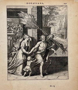
Sold2024Pieter de Jode I (1570-1634) & Otto van Veen (1556-1629) - Death pulling away a man from his familyEngraving "Death pulling away a man from his family", Antwerp, 1607. Size: 19 cm x 22 cmSee Sold Price
Sold2020C1650 Engraving Petrus de Jode AmurathesAn engraving of Petrus de Jode the Younger (1606-1674) and printed by Jan Meyssens of Amurathes. Antwerp, c1650. Fine condition, measures 5.25 x 7.5". Reserve: $40.00 Shipping: Domestic: Flat-rate ofSee Sold Price
Sold20211585 Engraving of Biblical Scene De JodeFine engraving by Gerard De Jode, C. Ryckemans, and Visscher circa 1585 of a religious scene with caption at bottom in Latin. Fine, light crease, measures 11.5 x 9". Reserve: $30.00 Shipping: DomesticSee Sold Price
4 days LeftTrillium Antique Prints & Rare BooksDe Jode, Rare, pub. 1593 - Map of Part of Germany (Sveviae Utriusq cum Germicae tum RheticaeUS$100
4 days LeftTrillium Antique Prints & Rare BooksDe Jode, Rare, pub. 1593 - Map of Austria (Austriae Ducatus Seu Pannoniae Superioris?)US$100
May 09Hunt and Peck Estate Services, Inc.Abraham Ortelius Map "Sabavdiae, et Bvrgvndiae Comitatus descriptio"US$70
1 day LeftDoyle New YorkVaugondy's map of Virginia and Maryland, a reduction of Fry and Jefferson's landmark mapUS$600
May 14Fleischer's Auctions1755 Map Partie de l'Amerique Septentrionale, qui comprend Le Cours de L'Ohio...US$200(3 bids)
May 09Hunt and Peck Estate Services, Inc.G. De L'Isle/Covens & Mortier Map Of Congo And The Country Of The CafresUS$140
May 09Hunt and Peck Estate Services, Inc.G. De L'Isle/Covens & Mortier Map Of Egypt, Nubia, And AbissiniaUS$140
2 days LeftJasper52Côte Nord-Est de la Nouvelle Calédonie…'. ROUBET. New Caledonia 1849 old mapUS$180
2 days LeftJasper52Pacific Islands. Dusky Sound. Wallis Tonga Cook Easter Pitcairn. BONNE 1788 mapUS$45
2 days LeftJasper52Carte de l'Isle de Bourbon, autrefois Mascareigne'. Réunion. BELLIN 1750 mapUS$70(1 bid)
2 days LeftJasper52NEW CALEDONIA. Nouvelle Caledonie. Loyalty Islands/Îles Loyauté. Nouméa 1931 mapUS$40


![[Map of France] De Jode, 1593: [De Jode, C.] "Artois Atrebatum regionis vera descriptio…" [Antwerp, 1593]. 46.7 x 36.8cm. On laid paper with watermark. A few stains to margins, tiny pin-hole near center, faint vertical crease to](https://p1.liveauctioneers.com/3532/125343/63770646_1_x.jpg?height=310&quality=70&version=1532476745)

![Map of Palestine - Engraving - Belgium, 16th Century: Terrae Sanctae, quae Promissionis terra, est Syriae pars ea, quae Palaestina uocatur... edited by Gerard de Jode. Drawn after Tilemann Stella. Copperplate engraving, hand-colored. [Antwerp, 1593]. Map](https://p1.liveauctioneers.com/1980/117218/60259210_1_x.jpg?height=310&quality=70&version=1520155929)