Sold2018Map: Territory of Arizona, 1899Territory of Arizona, 1899, Shows 9 Indian Reservations, Military, much more, good condition & contentSee Sold Price
Sold2018Mitchell: Antique Map of Territory of Montana, 1880Title/Content of Map: Territory of Montana Date Printed: 1880 Cartographer: Augustus Mitchell Material/Medium: Hand Coloured Engraving Size: 11 7/8" x 15" Small folio, has small tears along margin, noSee Sold Price
Sold2021The Purported Photograph of Josie EarpPurported Photograph of Josephine Sarah Earp in Prescott, Arizona territory in 1880 Quantity: 1 Condition: Fairly Good Condition Height: 54cm or approximately 21.26 inches Width: 23cm or aSee Sold Price
Sold20201889 Map of the Arizona territoryAuthor: Watson Title: 1889 Map of the Arizona territory Medium: Ink on Paper Dimensions: 11"X14.5" Map of the Arizona territory dated 1889. Engraved and published by Watson in Chicago. Key lower left.See Sold Price
Sold2017Lloyd: Map of Kansas and Other Territories, 1872Map: Kansas, and the Territories of Arizona, Colorado, New Mexico, Utah and Indian Territory (antique map) Cartographer: H.H. Lloyd Publisher: Stedman, Brown & Lyon Date: 1872 Size: 15.375 x 24.5 inchSee Sold Price
Sold20211895 Map of ArizonaTitle: 1895 Map of Arizona Author: Cram Medium: Ink on Paper Dimensions: 14.5"X22" Description: Map of the Arizona territory dated 1895. Engraved and published by George Cram in Chicago. Part of his WSee Sold Price
Sold20191886 County & Township map of Arizona & N. Mexico byA fine example of William M. Bradley's 1886 map of Arizona and New Mexico. Shows just ten counties in Arizona Territory and thirteen in New Mexico Territory (plus Indian Reservation in upper left of sSee Sold Price
Sold2019Map of Territories of New Mexico & Utah 108545Map published by J.H. Colton & Co., No. 172 William St., New York. Matted. Map is bright in color. Note there is no Arizona. No. 53. 16" x 13". City: State: Utah/New Mexico Date: c1860See Sold Price
Sold20241863 Johnson Map of US West -- Johnson's California Territories of New Mexico Arizona ColoradoTitle: 1863 Johnson Map of US West -- Johnson's California Territories of New Mexico Arizona Colorado Nevada and Utah Cartographer: Johnson & Ward Year / Place: 1863, New York Map Dimension (in.): 17.See Sold Price
Sold20231863 Johnson Map of US West -- Johnson's California Territories of New Mexico Arizona ColoradoTitle: 1863 Johnson Map of US West -- Johnson's California Territories of New Mexico Arizona Colorado Nevada and Utah Cartographer: Johnson & Ward Year / Place: 1863, New York Map Dimension (in.): 17.See Sold Price
Sold202119th C. Map of Indian Territory & 20th C. Kachina**Originally Listed At $300** Map: "Map of Indian Territory Drawn and Engraved on Copper Plate Expressly for Johnson's Cyclopedia" - Volume IV New York - A.J. Johnson Company, ca. 1880 to 1894. FigureSee Sold Price
Sold2017Handbook to Arizona 1878Heading: Author: Hinton, Richard J. Title: The Hand-Book of Arizona: Its Resources, History, Towns, Mines, Ruins and Scenery. Amply Illustrated. Accompanied with a New Map of the Territory Place PublSee Sold Price
Sold2017Johnson’s Map of California Territories, 18631863 Johnson’s California Territories of New Mexico, Arizona, Colorado, Nevada and Utah. Johnson and Ward, 17 x 24.5 inches. Late 1863 transitional map with New Mexico and Arizona divided verticallySee Sold Price
Sold2019Map of California & Territories of N.M., AZ, Colorado,Map by Johnson & Ward; bright colors, double truck, 8 counties (2) Lake county; Lake Bigler; (Note, Las Vegas is in Arizona). Approx. 26.5" x 18". There is some foxing & discoloration due to age. No tSee Sold Price
Sold20211880 Gray Map of Texas and Indian Territory -- Gray'sTitle: 1880 Gray Map of Texas and Indian Territory -- Gray's New Map of Texas and the Indian Territory Cartographer: F Gray Year/Place: 1880, Philadelphia Map Dimensions (in.): 17 X 26.4 in. DescriptiSee Sold Price
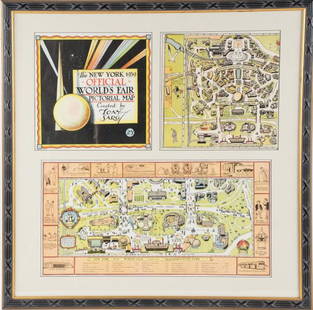
Sold2022Framed Tony Sarg 1939 World's Fair Pictorial MapTony Sarg (American, 1880-1942), "The New York 1939 Official World's Fair Pictorial Map Created by Tony Sarg 25¢" cover and Transportation Zone maps, three pieces matted and under glass in paintedSee Sold Price
Sold20231880 Gray Map of New Mexico and Arizona [verso] Mexico -- New Mexico and Arizona [verso] MexicoTitle: 1880 Gray Map of New Mexico and Arizona [verso] Mexico -- New Mexico and Arizona [verso] Mexico Cartographer: O. W. Gray Year / Place: 1880, Philadelphia Map Dimension (in.): 11.5 X 14.6 in. ThSee Sold Price
Sold2018Map of Railroad and County “Indian Territory"Map of Railroad and County “Indian Territory" 22" x 28" Map of Railroad and County “Indian Territory" (Rare!) shows Indian occupied Lands – Reservation in color, not dated but 1880’s likelySee Sold Price
Sold2024Mitchell's 1880 Map of The United States, and Territories. Together With CanadaTitle/Content of Map: Mitchell's 1880 Map of The United States, and Territories. Together With Canada Date Printed: 1880 Cartographer: S. Augustus Mitchell Material/Medium: Engraving Size: 14 x 22.5"See Sold Price
Sold2018Transitional western states with Gadsden Terr. – 1860sReserve Reduced! Great map of the West, naming Gadsden Territory as a separate region before it’s named Arizona. Map was issued shortly after the formation of Arizona, Nevada and Wyoming, each of whSee Sold Price
Sold2017Civil War Era Map of the United StatesMap of the United States and Territories. Henry F. Walling (1825 - 1889) & Ormando W. Gray (fl. 1860 – 1880). Lithographed Map. Boston, 1871. 17 x 25 1/2 inches sheetSee Sold Price
Sold20171870 SECTIONAL POCKET MAP OF THE STATE OF MISSOURI"Engraved from Official Draughts of Each County", published by George F. Cram & Co., the lower left corner denotes INDIAN TERRITORY, lower left legend outlines Railroads in Progress, Railroads CompletSee Sold Price
Sold2023"Outline & Index Map of New York City" New York: E. Robinson Co., 1885"Outline & Index Map of New York City" New York: E. Robinson Co., 1885. From Robinson's Atlas of the City of New York: embracing all territory within its corporate limits from official records, privatSee Sold Price
Sold2022Vintage map of North America, Johnson/Ward, 1865Dynamic map of the North American continent with Dakota still a complete territory (Wyoming still part of Dakota). Nevada, Utah, Arizona still with unsettled borders and Oklahoma remains Indian TerritSee Sold Price
Jun 15Mega International AuctionEIGHT BIG MOUNTAIN PEOPLE CRANE SHOU PLUS OFFICIAL MAP FOUR SCREEN AXIS FINE MOUNTEDUS$3,000
3 days LeftFreeman's | Hindman[CIVIL WAR] -- [ARIZONA TERRITORY]. KING, Governor John A. (1788-1867). Papers of New York GovernorUS$1,500
3 days LeftFreeman's | Hindman[NATIVE AMERICAN]. RANDALL, A. F. (1854-1916), photographer. Boudoir card featuring Apache subjectsUS$200
Jun 12Dan Morphy AuctionsPLATE CXIII. MAP OF INDIAN TERRITORY SHOWING DISTRIBUTION OF WOODLAND” FROM THE TWENTY-FIRSTUS$100
Jun 12Dan Morphy AuctionsGEOLOGY OF THE BLACK AND GRAND RAPIDS OF TEXAS INCLUDING THE EASTERN AND WESTERN CROSS TIMBERS,US$100
Jun 12Dan Morphy AuctionsMAP OF THE CHOCTAW NATION, INDIAN TERRITORY - COAL AND ASPHALT SEGREGATION 1903US$150
2 days LeftJasper52CENTRAL AMERICA. 'Mosquito Territory' Guatemala Belize. TALLIS/RAPKIN 1851 mapUS$70
Jun 12Dan Morphy AuctionsMAP OF THE CHOCTAW NATION, INDIAN TERRITORY - COAL AND ASPHALT SEGREGATION 1903US$100
Jun 08Simpson Galleries, LLC.JULIUS BIEN (1826-1909) AN AMERICAN CIVIL WAR RECONNAISSANCE MAP, "Map of Texas and Part of NewUS$100
Jun 09Heartland Artifact Auctions IncTin Drinking Cup, found in Tombstone Arizona, at the rear of the Old Oriental Saloon, onceUS$14(3 bids)
Jun 12Dan Morphy AuctionsBRUE'S MONUMENTAL WALL MAP OF TEXAS, UPPER CALIFORNIA & MEXICO, C. 1845US$500
Jun 08Simpson Galleries, LLC.J.H. Young (1792-1870) AN AMERICAN FEDERAL PERIOD MAP, "Mitchell's Travellers Guide Through theUS$500
Jun 12Dan Morphy AuctionsINDIAN TERRITORY - DEPARTMENT OF THE INTERIOR GENERAL LAND OFFICE, C.1883US$100
19 hrs LeftJasper521640 Gerritsz/De Laet Map of Brazil -- Provincia de Brasil cum Adiacentibus ProvinciisUS$320


![1880 Gray Map of New Mexico and Arizona [verso] Mexico -- New Mexico and Arizona [verso] Mexico: Title: 1880 Gray Map of New Mexico and Arizona [verso] Mexico -- New Mexico and Arizona [verso] Mexico Cartographer: O. W. Gray Year / Place: 1880, Philadelphia Map Dimension (in.): 11.5 X 14.6 in. Th](https://p1.liveauctioneers.com/5584/281528/148418612_1_x.jpg?height=310&quality=70&version=1678826634)


![[CIVIL WAR] -- [ARIZONA TERRITORY]. KING, Governor John A. (1788-1867). Papers of New York Governor (1 of 6)](https://p1.liveauctioneers.com/197/329785/177758343_1_x.jpg?height=282&quality=70&version=1715625218)
![[NATIVE AMERICAN]. RANDALL, A. F. (1854-1916), photographer. Boudoir card featuring Apache subjects (1 of 2)](https://p1.liveauctioneers.com/197/329785/177758596_1_x.jpg?height=282&quality=70&version=1715625218)


