Sold2022TWO NOVA SCOTIA GINGER BEER BOTTLESWilson & Sullivan, Halifax N.S. and Francis Drake, New Glasgow N.S. Both with stoppers, Minor flaws but good condition. Ht. 8 1/2". Total approx. weight 1.2 kg.See Sold Price
Sold2022Canada. Accumulation of New Brunswick, New Foundland, Nova Scotia, Prince Edward Island, 1860's toCanada. Accumulation of New Brunswick, New Foundland, Nova Scotia, Prince Edward Island, 1860's to 1940's. Generally circulated material from Victoria to George VI. A nice assortment of material greatSee Sold Price
Sold2023The Coast of New England, Nova Scotia, New France or Canada. GENTS MAG 1746 mapTITLE/CONTENT OF MAP: 'A New Chart of the Coast of New England, Nova Scotia, New France or Canada with the Islands of Newfoundl.d, Cape Breton St. John's &c. Done from the Original Publish'd in 1744 aSee Sold Price
Sold20241746 Large Engraved Map New England Nova ScotiaA New Chart of the Coast of New England, Nova Scotia, New France or Canada with the Islands of NewFoundl(an)d, Cape Breton, St. John and C.. by Nicolas Bellin, English version printed for Gentleman'sSee Sold Price
Sold2021PEI, New Brunswick, Nova Scotia Stamp CollectionCanada PEI, New Brunswick, Nova Scotia stamp collection. PEI: #9 F ($6), #11 F ($4 x 5), #13 F ($20), #14 F ($8), #15 VF MNH ($20 x 3), #16 F ($5 x 9). New Brunswick: #6 ($50 x 12), #7 ($7.50 x 10), #See Sold Price
Sold2016Map of New Brunswick & Nova Scotia, Newfoundland,Original engraving from Johnson's Atlas of the World, 1868. Map details cities, towns and territories. Dimensions: 18" x 26". No Reserve This item ships from Ocean View, DE.See Sold Price
Sold2022New Brunswick, Nova Scotia, Newfoundland, etc. - 1863Wonderful large and vintage map of Canada’s Maritime Provinces just a couple of years before the confederation of Canada. The map identifies forts, rivers, mountain passes, coastal features, toSee Sold Price
Sold2022New Brunswick, Nova Scotia, Newfoundland, etc.Lovely map of Canada’s Eastern Provinces with great original hand coloring. “New Brunswick, Nova Scotia, Newfoundland and Prince Edward Island,” published 1856 by Colton. A beautifuSee Sold Price
Sold2024New Brunswick, Nova Scotia, Newfoundland & Prince Edward IslandDescriptionTitle/Content of Map: New Brunswick, Nova Scotia, Newfoundland & Prince Edward IslandDate Printed: 1864Cartographer: Johnson & WardMaterial/Medium: EngravingSize: 14 x 18"Reserve: $65.00ShiSee Sold Price
Sold20231866 Johnson's New Brunswick, Nova Scotia, Newfoundland, and Prince EdwardTitle: 1866 Johnson's New Brunswick, Nova Scotia, Newfoundland, and Prince Edward Cartographer: Johnson and Ward Year / Place: 1866, New York Map Dimension (in.): 12.5 x 15.5 in. This is an excellentSee Sold Price
Sold2023Map of Canada’s New Brunswick, Nova Scotia, Newfoundland by ColtonTitle: Map of Canada’s New Brunswick, Nova Scotia, Newfoundland by ColtonDate/Period: 1859Materials: Hand colored steering engravedSize: 17 1/2 x 14 1/2”Newfoundland, New Brunswick, Nova ScotiSee Sold Price
Sold2019Lower Canada, New Brunswick, Nova Scotia' Quebec &TITLE/CONTENT OF MAP: 'Lower Canada, New Brunswick, Nova Scotia &c.; Inset map of Newfoundland' DATE PRINTED: 1862 IMAGE SIZE: Approx 31.0 x 45.0cm, 12.25 x 17.75 inches (Large) TYPE: Antique map withSee Sold Price
Sold2021New Brunswick & Nova Scotia 1888Title/Content of Map: New Brunswick & Nova Scotia 1888 Date Printed: 1888 Material/Medium: paper Size: approx. 14x11 inches Additional Info: John C. Lonngren & Son Standard Atlas of the World Reserve:See Sold Price
Sold2018New Brunswick & Nova Scotia.Title/Content of Map: New Brunswick & Nova Scotia. Date Printed: 1887 Cartographer: CRAM, GEORGE F. Size: 16X22.25 "Engraved expressly for the Standard World atlas." Shows Prince Edward Island. DetailSee Sold Price
Sold2018Colton: Antique Map of New Brunswick & Nova ScotiaTitle/Content of Map: New Brunswick & Nova Scotia by Colton Date Printed: 1859 Cartographer: H.J. Colton Material/Medium: Paper Size: 17 1/2" x 15" Hand colored, engraved Map. Published in New York inSee Sold Price
Sold2017Cram: Map of Canada New Brunswick & Nova Scotia, 1891Map: Dominion of Canada verso New Brunswick & Nova Scotia Date: 1891 From Cram's "Unrivaled Family Atlas of the World Indexed" TWO Maps, one on each side Size: 14.5 x 11 inches Please note that this lSee Sold Price
Sold2017Colton: Antique Map of New Brunswick, Nova Scotia, 1861Title/Content of Map: Canada, New Brunswick, Nova Scotia and Newfoundland Date Printed: 1861 Cartographer: J.H. Colton Material/Medium: Paper Size: 17 1/4" x 13" Hand colored steel engraved Map from 'See Sold Price
Sold2015New Brunswick, Nova Scotia, Newfoundland ... 1855New Brunswick, Nova Scotia, Newfoundland and Prince Edward Island 1855 J.H. Colton.Dimensions: 11" X 14 1/4".Inv.16-17See Sold Price
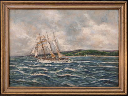
Sold2022Jack Lorimer Gray (1927 - 1981) NY/Canadian Artist OilJack Lorimer Gray (1927 - 1981) was active/lived in New York, Nova Scotia / Canada. Jack Gray is known for Ship, harbor, maritime activity. Medium: Oil on board Size: 20" x 28" Frame Size: 24" x 32" CSee Sold Price
Sold2020New Map of That Portion of North America 1851New Map of That Portion of North America Exhibiting the United States and Territories, the Canadas, New Brunswick, Nova Scotia and Mexico also Central America and the West India Islands, 1851, Jacob MSee Sold Price
Sold2022Canadian Provinces, 1686-1940s, a large accumulation of mint and used in two albumsCanadian Provinces, 1868-1940s, a large accumulation of mint and used in two albums, include British Columbia, Prince Edward Island, New Brunswick, Nova Scotia and Newfoundland, from the first perforaSee Sold Price
Sold2017Vintage Paper W Canvas Map of USAroom Sized Vintage Paper W Canvas Map of USA. Reads as the 'New Map of That Portion of North America, Exhibiting the United States &Territories, The Canadas, New Brunswick, Nova Scotia, and Mexico, alSee Sold Price
Sold202219th Century Chart of Northern New England and New France.A new Chart of the Coast of New England, Nova Scotia, New France or Canada, with the Islands of Newfoundland, Cape Breton and St. John’s.See Sold Price
Sold20171746 Leather Volume Map New England English Rebellion1746 Volume , featuring large folding “New Chart of the Coast of New England Nova Scotia, New France or Canada…”, of Gentleman’s Magazine for the year 1746 containing all twelve issues and SupSee Sold Price
7 days LeftBrandywine Valley AuctionsImportant Vintage American School Chicago Woman Artist Abstract Figurative Expressionist June LeafUS$50
Aug 06Joe R. Pyle Complete Auctions & Real Estate1934 "N. Brunswick J-6372, 1937 "Nova Scotia 61-570, & 1935 Brit Columbia 14-581 License US$5
6 days LeftCalifornia Historical DesignWallace Robinson MacAskill (1887-1956) Tonalist Photograph "Nocturne" c1910sUS$150
Sep 01Broward Auction GalleryMelbourne Hardwick (MA,Canada,1857-1916) watercolor painting antiqueUS$10
JG AutographsCardinal R. Cushing - Archbishop of Boston - Autographed Oversized Mounted PhotographUS$25