Sold2019Franz Anton Schrambl (1751-1803), "General KarteFranz Anton Schrambl (1751-1803), "General Karte sammtlicher Entdeckungen auf den grossen Weltreisen des. Kapt. Jakob Cook," 1788, H.- 25 1/4 in. W.- 41 1/4 in.See Sold Price
Sold2017Schraembl: Antique Map of Gulf of Mexico, 1789Map: Untitled map of the Gulf of Mexico and Central America Cartographer: F.A. Schraembl Place & Date: Vienna / 1789 Size: 23 1/4" x 20" Condition: outline color; light overall age toning A scarce andSee Sold Price
Sold2022Celestial chart.- Schraembl (Franz Anton)NO RESERVE Celestial chart.- Schraembl (Franz Anton) Stereographischer Entwurf des Gestirnten Himmels, detailed chart of the Northern Celestial Hemisphere, the constellations presented as figures accoSee Sold Price
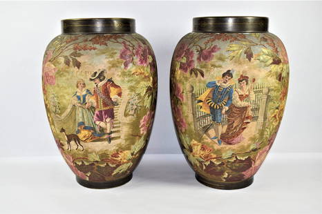
Sold2023Large pair of antique Royal Bonn, Franz Anton Mehlem vasesA large pair of German " tapestry finish" pottery vases by franz Anton Mehlem for Royal Bonn circa 1890-1920 in very good condition. Approximate measurements: 18"H x 12" in diameterSee Sold Price
2018Homann: Antique Map of Schweiz Switzerland, 1751Title/Content of Map: La Suisse, divisée en ses tréze cantons'. Schweiz Switzerland Date Printed: 1751 (This date is printed on the map) Image Size: Approx 48.0 x 61.5cm, 19 x 24 inches (Large); PleSee Sold Price
Sold202419th Century Museum Piece German Franz Anton Mehlem Floor Lamp 75" HLate 19th Century, beginning 20th Century Museum Piece German Franz Anton Mehlem Oil Floor Lamp composed of ceramic urn all hand painted and gilt, bronze base, glass shade with high relief design, wasSee Sold Price
Sold2021FRANZ ANTON COUFAL OIL PAINTING ON CANVASFranz Anton Coufal (Austrian,1927-1999) oil painting on canvas depicting a village scene. Signed lower right. Measures 23 1/4" x 19 1/4" + 2 3/4" frame.See Sold Price
Sold2021Royal Bonn German Antique Jardiniere and PedestalAntique German Royal Bonn pottery jardiniere and matching pedestal. Fine quality workmanship with polychrome floral design fine luster finish. Signed Franz Anton Mehlem Royal Bonn and M factory mark.See Sold Price
Sold2023Antique Map of Four Cities in IrelandAntique hand colored print depicting maps of Galway, Dublin, Limerick, and Cork. Map originally by Braun, Georg, Hogenberg, Franz. [Map: 17" H x 22" W; Frame: 19" H x 24" W].See Sold Price
Sold2020Nymphenburg Porcelain Commedia dell'Arte FiguresPair of Antique Nymphenburg Porcelain Commedia dell'Arte Figures of Capitano and Leda , impressed shield marks, after designs by Franz Anton Bustelli, impressed "272" and "0", marked "L" and "16", h.See Sold Price
Sold2019Nymphenburg Porcelain Commedia dell'Arte FiguresTwo Antique Nymphenburg Porcelain Commedia dell'Arte Figures of Scaramuz and Corine, impressed shield marks, after designs by Franz Anton Bustelli, impressed "240" and "0", and "205" and "3", h. 8 in.See Sold Price
Sold2021Nymphenburg Porcelain Commedia dell'Arte FiguresPair of Antique Nymphenburg Porcelain Commedia dell'Arte Figures of Julia and Pantalone , impressed shield marks, after designs by Franz Anton Bustelli, impressed "11" and "0", h. 8 1/4 in., w. 4 1/2See Sold Price
Sold2022Antique Japanese Color Woodblock Map of Yedo PrintKeisai Yeisen ( Japanese, 1789 - 1851 ). Subject matter is that of a colored woodblock print depicting a map on paper of Yedo, Japan. Features character marked name to left center. Verso with printedSee Sold Price
Sold2018Sir William Hamilton, Hand-colored Engraving, Plate 46**Originally Listed At $350** Artist Johann Heinrich Wilhelm Tischbein (German, 1751-1829), Plate 46, from William Hamilton's (born Scotland 1730, died England 1803) "Peintures des Vases Antiques de lSee Sold Price
Sold2017Ortelius: Antique Map of the World, 1587Map: World Date Printed: 1587-1612 Cartographer: Abraham Ortelius Material/Medium: Paper Size: *** Approx 16" x 21" Original hand color. Copperplate engraved.One of the most famous and iconic world maSee Sold Price
Sold2017Levasseur: Antique Map of North America, 1840Title/Content of Map: 1840 Levasseur Map of North America - Amerique Septrentionale Date Printed: 1840 Paris Cartographer: V. Levasseur Size: 11 x 16.5 in. Condition: Excellent. Minor age toning; issuSee Sold Price
Sold2021Four Antique MapsFour antique maps. Including a very early hand made paper map of Florida and Virginia. Fragment of old newspaper on back dated 1630. Unframed, each approx H 21" W 24". All in excellent condition, minoSee Sold Price
Sold2023TWO ANTIQUE MAPS OF CHINA.Two antique maps of China, including Chinae by Abraham Ortelius, 1595, image 14.25” x 18.25”, with map of Eastern Asia, Le table de la region orientale, image 10” x 13.5”.See Sold Price
Sold2017Jaillot: Antique Map of North America, 1696Map: 1696 Jaillot Map of North America (California as an Island) -- Amerique Septentrionale Divisee en ses Principales Parties Date Printed: 1696 Amsterdam Cartographer: H. Jaillot Size: 19.3 x 23 in.See Sold Price
Sold2018Homann: Antique Map of New England, 1720The map names New England as "Almouchi Cosen" as well as Nova Anglia, while present-day New York State is named variously as New Jork, Nieuw Nederland and Novum Belgium (New York, New Netherlands andSee Sold Price
Sold2024Matthaus Merian 1627 Antique Map Engraving "Virginia" from Theodore de Bry's "Grand Voyages" #1Antique 1627 map of Virginia by Matthaus Merian after John Smith's 1612 map, from Theodore de Bry's "Grand Voyages". Please see "The Philidelphia Print Shop" sheet shown in final photo. Good conditionSee Sold Price
Sold2017Forlani: Antique Map, Town View of Venice, 1569Title: Venetia, Splendid 1569 Lafreri-school town view of Venice Map maker: Paolo Forlani, De’ disegni delle più illustri città et fortezze del mondo Place and Year: Venice, 1569 Dimensions: 19.2See Sold Price
Sold2024John Speed 1676 Original Antique Map of Virginia and Maryland No ColorAntique 1676 map of Virginia and Maryland engraved by Francis Lamb and republished by Thomas Basset & Richard Chriswell after John Speed's 1611 atlas. With "The Description of Mary-Land" text on reverSee Sold Price
Sold2024Antique map of Virginia - Florida by Blaeu W. 1642-43Virginia and Florida. "Virginiae partis australis, et Floridae partis orientalis, interjacentiumque regionum nova descriptio". Orig. copperplate engraving, W. J. Blaeu, published by C. and J. Blaeu inSee Sold Price
3 days LeftJasper52Spigelia Anthelmia quadriphylla Wormbush Pinkroot, erva. Blatta/cockroach 1751US$10
2 days LeftJasper52Guinea birds. Guinea Pheasant, Sestro Pheasant. Whidah Pheasant. Whidah Crown-bird. Pokko bird -US$35
3 days LeftJasper52PUERTO RICO. Inset Port San Juan. RAND MCNALLY 1912 old antique map plan chartUS$15
Jul 06Worthington Galleries1778 Captain Cook Map of Port Praia by Robert Bernard [Port Praya dans l'Isle de St Jago]US$10
3 days LeftJasper52WEST INDIES Caribbean Windward Leeward Islands Barbados Pirates? MALLET 1683 mapUS$240
6 days LeftTrillium Antique Prints & Rare BooksMunster, pub. 1614 - Map of the AmericasUS$160(5 bids)
6 days LeftTrillium Antique Prints & Rare BooksKircher, pub. 1682 - Pair of Engravings: Map of South Africa & Three Maps to One sheet of theUS$80(2 bids)
6 days LeftTrillium Antique Prints & Rare BooksDe Jode, Rare, pub. 1593 - Frontispiece or Title Page with Map of Germany, Poland and the LowUS$100
Featured3 days LeftJasper52General Map of the West Indies'. West sheet only. Bryan EDWARDS. Caribbean 1794US$700
3 days LeftJasper52Ozama and Brujuelas Basins. Dominican Republic. Hispaniola 1885 old mapUS$10(1 bid)


![Antique Map of Four Cities in Ireland: Antique hand colored print depicting maps of Galway, Dublin, Limerick, and Cork. Map originally by Braun, Georg, Hogenberg, Franz. [Map: 17" H x 22" W; Frame: 19" H x 24" W].](https://p1.liveauctioneers.com/1221/275442/145337791_1_x.jpg?height=310&quality=70&version=1674615534)


![1778 Captain Cook Map of Port Praia by Robert Bernard [Port Praya dans l'Isle de St Jago] (1 of 1)](https://p1.liveauctioneers.com/6084/334081/180514614_1_x.jpg?height=282&quality=70&version=1719094844)


