Sold20191831 Hooker Lower and Midtown Manhattan Map -- Map ofTitle/Content of Map: 1831 Hooker Lower and Midtown Manhattan Map -- Map of the City of New York Date: 1871 reissue, New York City Cartographer: W Hooker Size: 15.4 x 12.2 in. Nicely color outlined MaSee Sold Price
Sold2022LAPIE ORIGINAL ANTIQUE MAP ASIA MINOR 1831L' ASIE MINEURE 1831 SIZE: 25.5 X 20 INCHES APPROX. UNFRAMEDSee Sold Price
Sold2017T.E Nicholson: Antique Map of Warsaw, 1831Title: Map of Warsaw by T.E Nicholson Date: 1831 Medium: Hand Colored Engraving Dimensions (in.): 16.5 x 13.5 No Reserve: This lot starts at $1 and has no reserve as a courtesy so that collectors canSee Sold Price
Sold2017Antique Map of Scotland, Henry Teesdale 1831Antique Map of Scotland, Henry Teesdale 1831 Approx 65.0 x 52.5cm, 25.75 x 20.75 inches (Large) Scotland' The top image on the right hand side shows the entire map. To view a close up of the map showiSee Sold Price
Sold2023Antique Double Sided 1913 NYC Borough MapsAntique map of boroughs of Queens, Manhattan and The Bronx. Marked Supplement to the Brooklyn Eagle Almanac 1913 Affixed with two panels of acrylic. Approximately 35 x 30 inches. Evident wearing due tSee Sold Price
Sold2018Mitchell: Antique Map of New York City, 1860Title/Content of Map: 1860 Mitchell Map of New York -- Plan of New York & c. Date Printed: 1860, Philadelphia Cartographer: S Mitchell Size: 13.5 x 10.5 in. An excellent map of lower Manhattan, EllisSee Sold Price
Sold2018SDUK: Antique Map of Ancient Egypt, 1846Title/Content of Map: 'ANCIENT EGYPT' Nile Valley ancient names & sites. Original colour. Date Printed: This map was originally engraved in 1831. This date is printed on the map. This edition of the mSee Sold Price
Sold2024New York Walk Book, Illust. Amer Geo Society, 1923Antique Map and trail soft cover book, illustrated with maps , topography in color and in black and white. Westchester, Rockland , Nassau counties,Manhattan, Bronx, up state NY and northern New JerseySee Sold Price
Sold20221764 Bellin map of Manhattan (Hayward 1861)Antique city plan of Lower Manhattan, executed by S. Bellin in 1764, redrawn by George Hayward for the Valentine’s Manual of 1861. Includes the Custom House, City Hall, the Fort, the House of tSee Sold Price
Sold202311 Engraved Scenic Views and Maps inc. UVA, GA Female College, plus Postcard AlbumGroup of eleven (11) antique prints and lithographic maps. Includes University of Virginia, Charlottesville by W. Goodacre, published London, 1831 by I.T. Hinton, Simpkin & Marshall; Georgia Female CoSee Sold Price
Sold20181831 London General Gazetteer folding maps.1831 London General Gazetteer folding maps.-- Dimensions: ---See Sold Price
Sold2024John B. Salterini wrought iron bar cart trolley server.John B. Salterini wrought iron bar cart trolley server. Dimensions: Height: 35.75 inches, Width: 45 inches, Depth: 18.75 inches. --- - - We offer curbside delivery to NYC, Manhattan, Close Brooklyn, HSee Sold Price
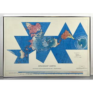
Sold2023Richard Buckminster Fuller Dymaxion World Map Print, 1980 FullerRichard Buckminster Fuller Dymaxion World Map Print, 1980 Fuller Dimensions: H: 22.5 inches: W: 34.5 inches --- -- We offer curbside delivery to NYC, Manhattan, Close Brooklyn, Hoboken about a week afSee Sold Price
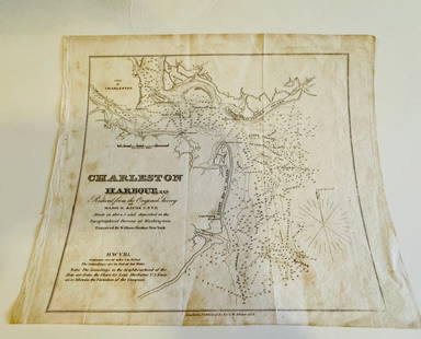
Sold2024Charleston Harbour map- Blunt 1833 mapCharleston Harbour map marked from New York published by E and G W. Blunt 1833. Engraved by William HookerSee Sold Price
Sold201717 travel maps/brochures/pamphlets17 travel maps/brochures/pamphlets including Germany; Rome to Florence by motor car; Italy; The Grunewald New Orleans; Modern control of plant diseases; New York streets-Manhattan, Bronx, Brooklyn, quSee Sold Price
Sold2017Bertoja/Galle: Antique Plan & View of Venice, 1831Map: Pianta della Regia Città di Venezia Cartographer: Bertoja / A. Lazzari / G. Gallo Place & Date: Venice / 1831 Size: 22 1/2" x 19 1/2" Condition: b&w. some wrinkling and and a few nicks in the edSee Sold Price
Sold2020Antique Wooden Manhattan Beach Art Picture!Antique unique hanging advertisement artwork by "Manhattan Beach Estates NY" made on a real wood plaque, with map and information on the neighborhood, measures approx 10.5"x 9" inches, one inch thick.See Sold Price
Sold2017Ortelius: Antique Map of the World, 1587Map: World Date Printed: 1587-1612 Cartographer: Abraham Ortelius Material/Medium: Paper Size: *** Approx 16" x 21" Original hand color. Copperplate engraved.One of the most famous and iconic world maSee Sold Price
Sold2017Levasseur: Antique Map of North America, 1840Title/Content of Map: 1840 Levasseur Map of North America - Amerique Septrentionale Date Printed: 1840 Paris Cartographer: V. Levasseur Size: 11 x 16.5 in. Condition: Excellent. Minor age toning; issuSee Sold Price
Sold2021Four Antique MapsFour antique maps. Including a very early hand made paper map of Florida and Virginia. Fragment of old newspaper on back dated 1630. Unframed, each approx H 21" W 24". All in excellent condition, minoSee Sold Price
Sold2023TWO ANTIQUE MAPS OF CHINA.Two antique maps of China, including Chinae by Abraham Ortelius, 1595, image 14.25” x 18.25”, with map of Eastern Asia, Le table de la region orientale, image 10” x 13.5”.See Sold Price
Sold2017Jaillot: Antique Map of North America, 1696Map: 1696 Jaillot Map of North America (California as an Island) -- Amerique Septentrionale Divisee en ses Principales Parties Date Printed: 1696 Amsterdam Cartographer: H. Jaillot Size: 19.3 x 23 in.See Sold Price
Sold2018Homann: Antique Map of New England, 1720The map names New England as "Almouchi Cosen" as well as Nova Anglia, while present-day New York State is named variously as New Jork, Nieuw Nederland and Novum Belgium (New York, New Netherlands andSee Sold Price
Sold2024Matthaus Merian 1627 Antique Map Engraving "Virginia" from Theodore de Bry's "Grand Voyages" #1Antique 1627 map of Virginia by Matthaus Merian after John Smith's 1612 map, from Theodore de Bry's "Grand Voyages". Please see "The Philidelphia Print Shop" sheet shown in final photo. Good conditionSee Sold Price
4 days LeftJasper52MEDITERRANEAN.Corsica Sardinia;Balearics Baleares;Valletta,Malta SDUK 1844 mapUS$100
4 days LeftJasper52MEDITERRANEAN.Corsica Sardinia;Balearics Baleares;Valletta,Malta.SDUK 1844 mapUS$100
4 days LeftJasper52MEDITERRANEAN.Corsica Sardinia;Balearics Baleares;Valletta,Malta.SDUK 1844 mapUS$100
7 days LeftTrillium Antique Prints & Rare BooksForbes - Red, Blue, and White Lotus, of HindostanUS$75
7 days LeftTrillium Antique Prints & Rare BooksForbes - Pair of Engravings of Fragrant Screw Pine (Pandanus odoratissimus) The Fruit of the KeuraUS$75
6 days LeftAlbion AuctionsCooke, George 1801 Antique Map. World Hemispheres by ArrowsmithUS$20(3 bids)
6 days LeftAlbion AuctionsGentleman's Magazine 1778 Canal Map. Belfast to Loughneagh Northern IrelandUS$5(1 bid)