Sold2017Framed Geographica Map Engraving (28E-EK)Framed Authentic Nova Totius Terrarum Orbis Geographica AC Hydrographica Tabula Map. Mixed Engraving printed in the late 1800's to early 1900's. All have the Mixed stamp from the Museum. These are theSee Sold Price
Sold2020(2 Pc) Framed Antique Celestial Map EngravingsDESCRIPTION: A lot of two antique celestial copperplate engravings from the series Harmonia Macrocosmica by Andreas Cellarius. The first "Sitvus Circvlis Cirvn Terra Coelestibvs Data" Engraved by JohaSee Sold Price
Sold2021FRAMED J.H. COLTON MAP OF NORTH AMERICA CA INSETFramed engraving on paper, Map of North America from the Latest Authorities, published by J.H. Colton (Joseph Hutchins Colton, 1800-1893), No. 86 Cedar St., New York, 1846, drawn and engraved by J.M.See Sold Price
Sold2021Framed Town of Greenburgh Map EngravingTown of Greenburgh Engraving, copyright to lower right corner reads ‘Julius Bien & Co. 1983’,’, verso reads ‘A.I. FRIEDMAN’, subject a map of part of the town of Greenburgh, shows various toSee Sold Price
Sold2023CIVITATES ORBIS TERRARUM ATLAS MAP OF VLISSINGENFramed hand-colored engraving on paper, map of the fortified town of Flissinga (Vlissingen), plate from "Civitates orbis terrarum," Georg Braun (German, 1541-1622) and Frans Hogenberg (Flemish, 1535-1See Sold Price
Sold20212) STIELER & MITCHELL MAPS EUROPE, TURKEY & GREECE(lot of 2) Framed maps, including: (1) engraving with hand coloring on paper, German map of Europe, Turkey, Greece, and the Ionian Islands, from "Stielers Schul-Atlas," published by Justus Perthes, GoSee Sold Price
Sold2022Sussex.- Jansson (Jan) Suthsexia vernacule Sussex,NO RESERVE Sussex.- Jansson (Jan) Suthsexia vernacule Sussex, map of the county, engraving with later hand-colouring, platemark 385 x 515 mm (15 1/8 x 20 1/4 in), good margins, German text verso, centSee Sold Price
Sold2019(2) HAND-COLORED GERMANIC MAPS, NUREMBERG(lot of 2) Framed hand-colored engravings on paper, maps of Central Europe, including: (1) "Tabula Geographica: Principatus Gotha, Coburg et Altenburg," Johann Baptist Homann (1663-1724), Nuremberg, sSee Sold Price
Sold20211796 MAP OF NORTH & SOUTH CAROLINA, DENISON, FRAMEJ. Denison (American, 18th century). "Map of North and South Carolina" -1796, from "Morse's Universal Geography", engraving. Framed. Provenance: From the Lifetime Collection of Billy S. Arant, Jr., ChSee Sold Price
Sold2023Jan Van Eycken 1800s Engraving A Bountiful Harvest Signed FramedJean Baptiste van Eycken (Belgian, 1809 – 1853). Abundance. Antique engraving on wove paper after the original by master engraver Thomas Vernon (British, 1825-1872). Signed in the plate. Year:See Sold Price
Sold2019Antique 1806 Robert de Vaugondy Map of FranceAntique 1806 Robert de Vaugondy Map of France. Antique early 19th century hand colored engraving. Framed and matted. Measures 14.5 x 17 inches.See Sold Price
Sold2018Indiana and Ohio Map EngravingProfessionally framed excellent condition 17" x 18.5" Provenance: The Larry & Julia Pollock collection of Shaker Hgts Ohio. Originally purchased from Through the Looking Glass in France .See Sold Price
Sold2020TEXAS MAP ENGRAVING PANHANDLE COUNTIES INSETFramed Texas map, hand-colored engraving on paper, a page from an atlas, plate 68, published by William Bradley, c.1880, an inset with Panhandle counties, within a geometric border, sight: approx 17.5See Sold Price
Sold20221833 map engraving of the Southern StatesTitle: 1833 map engraving of the Southern States Provenance/Additional Information: In an old painted black pine frame. Total framed size is approximately 6 1/2” x 8”. Condition: GC ShippiSee Sold Price
Sold2019Indiana and Ohio Map EngravingProfessionally framed excellent condition 17" x 18.5"See Sold Price
2019Indiana and Ohio Map EngravingProfessionally framed excellent condition 17" x 18.5"See Sold Price
Sold2021SIX ANTIQUE MAP ENGRAVINGSeach framed under glass each: 15 x 21 1/4 inches; 17 x 23 1/2 inches frameSee Sold Price
Sold201917th century Morden map engravingsTwo 17th century County map engravings by Robert Morden, Hampshire & Monmouth, 37 x 42 cm and 35 x 42 cm respectively, mounted, framed and glazedSee Sold Price
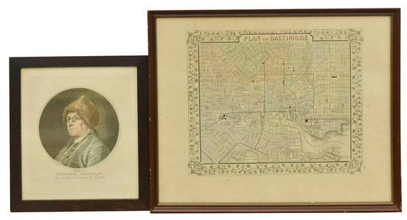
Sold2020(2) BEN FRANKLIN RUOTTE & BALTIMORE MAP ENGRAVINGS(lot of 2) Framed engravings on paper, including: (1) Benjamin Franklin (American, 1706-1790), after the original drawing by Charles Nicolas Cochin II (French, 1715-1790), engraved by C. Ruotte (LouisSee Sold Price
Sold2022Ortelius 16th Cent. ''Americae Siv Novi Orbis' MapAbraham Ortelius 16th Cent. ''Americae Siv Novi Orbis Nova Descriptio'' Map Engraving. Hand tinted Western Hemisphere map of America circa 1570-73, printed in Antwerp. Gallery framed with glass on botSee Sold Price
Sold2018London Farrington Ward Aquatint Map B. Cole EngravingCirca 1756 by B. Cole Copper Engraving. Framed. Sight: 15.25 in. H x 19.375 in. W, Frame: 22.25 in. H x 25.875 in. W x .75 in. D.See Sold Price
Sold2022[MAPS]. –– [ENGLAND]. A group of three 18th century maps of...[MAPS]. –– [ENGLAND]. A group of three 18th century maps of English towns and territories. Original map engravings depicting Bath, Suffolk, and the Remote British Isles. Framed and matted.See Sold Price
Sold2017A Framed Engraving with Hand Coloring of a WorldA Framed Engraving with Hand Coloring of a World Map, after Abraham Ortelius14-1/2 x 20-1/See Sold Price
Sold2021Jan Jansson Map of BritanniaJan Jansson Map of Britannia , "Britannis Prout Divisa fuit Temporibus Anglo-Saxonum, Praesertim Durante Illorum Heptarchia", Amsterdam, c. 1646, hand-colored engraving, Anglo-Saxon map, with vignetteSee Sold Price
2024Rapid Estate Liquidators and Auction GalleryFramed Collection Engravings & A Map From The Excursions In The County Of Sussex Published In 1822See Sold Price
Featured2 days LeftJasper52Saint Paul cures the lame man - Original antique engraving after G Freman, 17th century.US$80(1 bid)


![[MAPS]. –– [ENGLAND]. A group of three 18th century maps of...: [MAPS]. –– [ENGLAND]. A group of three 18th century maps of English towns and territories. Original map engravings depicting Bath, Suffolk, and the Remote British Isles. Framed and matted.](https://p1.liveauctioneers.com/928/252933/131521915_1_x.jpg?height=310&quality=70&version=1656110480)


