Sold2024Persia, Afghanistan and Baluchistan. South West Asia. RAND MCNALLY 1912 mapTITLE/CONTENT OF MAP: 'Persia, Afghanistan and Baluchistan' DATE PRINTED: 1912 IMAGE SIZE: Approx 26.5 x 34.0cm, 10.25 x 13.5 inches (Large) TYPE: Antique colour (color) atlas map CONDITION: Good; suiSee Sold Price
Sold2023MAP, Malta, TirionMalta. Isaac Tirion, Nieuwe Kaart van't Eiland Maltha met Gozo en Comino..., from Nieuwe en Beknopte Hand Atlas, 1761 (dated). Hand Color. Handsome, large map of the Maltese Islands with superb detailSee Sold Price
Sold2021Carte Particuliaire de la Coste D'or, 1750Carte Particuliaire de la Coste D'or, 1750A large color sea chart of the coast of Ghana, by Jacques-Nicolas Bellin as a part of his work on the large atlas, Hydrographie Francais23.5 x 17.75 inchesSee Sold Price
Sold20231885 Atlas MAPS George Crams Unrivaled World Cerography Cartography HUGE FOLIO1885 Atlas MAPS George Crams Unrivaled World Cerography Cartography HUGE FOLIO A scarce, 19th-century atlas that showcases the best of George F. Crams cerographic color maps of the world. George F. CrSee Sold Price
Sold2018Rand, McNally & Co.'S New Business Atlas Map of BostonTitle: Rand, McNally & Co.'S New Business Atlas Map of Boston Date: 1909 ca. Cartographer: RAND, MCNALLY & CO. Size: 26 X 19 Large full color city plan with two insets: Environs of Boston and BusinessSee Sold Price
Sold2019Rare 1st ed. 1847 ethno map of Europe/AsiaA large full color map of Europe and Asia showing the ethnographic distribution of people. Includes an accompanying chart. From the first comprehensive physical atlas of the world. This map comes fromSee Sold Price
Sold2024XL 1885 Robinsons Atlas Of NYC Illustr. BookAntique, Robinsons atlas of the city of New York, published by E.Robinson, New York, 1885. Complete with plate engravings in color, engraved by A.H. Mueller and printed by F.Bourquin and with 38 colorSee Sold Price
Sold2016Large geologic map of YellowstoneHeading: Author: U.S. Geological Survey Title: Yellowstone National Park and North Western Wyoming Place Published: Washington Publisher: Date Published: c.1885 Description:See Sold Price
Sold2018Hondius, Joducius and Mercator, Gerard. Cyprus Ins:from Atlas Sive Cosmographicae, 1619 or somewhat later, copperplate engraving with hand color showing a large map of Cyprus below which are inset maps of Lemnos, Chios, Lesbos, Euboea, Kythera, and RhSee Sold Price
Sold2018Hondius, Joducius and Mercator, Gerard. Cyprus Ins:from Atlas Sive Cosmographicae, 1619 or somewhat later, copperplate engraving with hand color showing a large map of Cyprus below which are inset maps of Lemnos, Chios, Lesbos, Euboea, Kythera, and RhSee Sold Price
Sold20191909 McNally State & Seneca Co. Ohio Survey/AtlasClean, solid atlas containing full-color maps of each state and maps of the world. Large 19 x 26 Railroad Map of Ohio detached but separate (very good cond.) Separate foldout map of the world is detacSee Sold Price
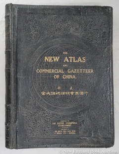
Sold2023Dingle, Edwin John51. Dingle, Edwin John. The New Atlas and Commercial Gazetteer of China. 28 color-printed maps and 18 color-printed statistical tables. Large folio, publisher's black cloth decorated in gilt and blindSee Sold Price
Sold20161885 Tunison's New Mexico MapTunison: ''Tunison's New Mexico''. 1885. Source: From Peerless Universal Atlas of the World. Information: 13 counties, published in Jacksonville, IL. Measures 12'' x 10'', fine color on verso ''TunisoSee Sold Price
Sold2019Large & Scarce Bus. Map of Texas, 1892Impressive and highly detailed full color lithographed map from what is considered the best large format American atlas of the latter nineteenth century. Rand McNally’s 1892 Indexed Atlas of the WorSee Sold Price
Sold2021(INDONESIA.) Dutch East Indies Topographic Department.(INDONESIA.) Dutch East Indies Topographic Department. Schetskaart van de Residentie Palembang. Massive color-lithographed topographical case map of southern Sumatra. 4 large panels, each 29x35 inchesSee Sold Price
Sold2022Large RR map of Florida from scarce 1898 Cram's AtlasDramatic and huge map of Florida naming and showing all rail lines in the state. Every rail line is named, numbered and color-coded by a legend on the map. From the very scarce Cram’s BankersâSee Sold Price
Sold2023RR map of New Mexico from scarce 1898 Cram’s Atlas.Large and dramatic double-page map of New Mexico naming and showing all rail lines in the state. Every railroad line is named, numbered, and color-coded by a legend on the map. From the very scarce CrSee Sold Price
Sold2023RR map of Arizona from scarce 1898 Cram’s Atlas.Large and dramatic double-page map of Arizona naming and showing all rail lines in the state. Every railroad line is named, numbered, and color-coded by a legend on the map. From the very scarce Cram�See Sold Price
Sold2024Siam and the Malay Archipelago. Indonesia Indochina Philippines. TIMES 1895 mapTITLE/CONTENT OF MAP: 'Siam and the Malay Archipelago' DATE PRINTED: 1895 IMAGE SIZE: Approx 38.5 x 25.5cm, 15.25 x 10 inches (Large) TYPE: Antique colour atlas map CONDITION: Good; suitable for framiSee Sold Price
Sold2023Lizars, Daniel 1831 LG Rare HC Map. East India Islands. Philippines Indonesia BorneoLarge Folio Copper Engraved Map Published 1831-2 by John Hamilton, Successor to Daniel Lizars, Edinburgh for "The Edinburgh Geographical and Historical Atlas..." First Edition by Daniel Lizars. Very fSee Sold Price
Sold2023Large Continental Atlas BookLarge Continental Atlas book by Milton Brown 1893. Hundreds of maps in color. Nice condition, some wear.See Sold Price
Sold2019Bartholomew, John 1922 Pair Large Maps of East Indies"Farther India" showing Siam, Indonesia, Singapore, Malaysia. Together with "Malay Archipelago" Large Lithograph Map Published 1922 by The Times, London for "The Times Survey Atlas of the World" MapsSee Sold Price
Sold2022MOSER LARGE DECORATIVE FOOTED 2-COLOR COMPOTE.C. 1885. This rare applied acorn and insect compote is enameled in a naturalistic Moser form. The colors are stunning and the top blends together where the tree trunk base meets. The compote is signedSee Sold Price
Sold20191776 map of France by Zatta w/huge marginsReserve Reduced! "Lovely and large double-page copperplate engraved map of France from the most comprehensive world atlas produced in Italy in the 18th century. Original hand-color in outline with lovSee Sold Price
Jun 13Swann Auction Galleries(COLORADO.) Louis Nell; and Chain, Hardy & Co. Nell's Topographical & Township Map of the State ofUS$600
4 hrs LeftJasper5214 kt. Yellow Gold - 14x15mm Large Golden South Sea Pearl - Necklace with pendant - 0.04 ctUS$170(1 bid)
4 hrs LeftJasper5213x14mm Large Golden South Sea Pearl - 14 kt. Yellow gold - Necklace with pendantUS$120
1 day LeftJasper52Western Africa by Edward Weller. Early British/French settlements 1860 old mapUS$40
1 day LeftJasper52Western Africa by Edward Weller. Early British/French settlements 1859 old mapUS$40
Featured1 day LeftJasper52Africa. Mauritius, Bourbon (Reunion) & Natal by Edward Weller 1860 old mapUS$55
6 days LeftBidhausMichael Kors HAMILTON LEGACY Belted Satchel Large MK Signature 30F1G9HS7B Women's PVC LeatherUS$5
1 day LeftJasper52L'Afrique Françoise ou du Senegal'. French West Africa. DE L’ISLE 1727 mapUS$100