Sold2022Lloyd's official map of the State of Tennessee, 1863LLOYD, James T. (19th Century). and Charles A. REEVES.Lloyd's official map of the State of Tennessee, 1863. Folding lithographed map with original stencilled color. New York: J.T. Lloyd, 1863. 32" x 4See Sold Price
Sold2022(KENTUCKY.) J.T. Lloyd. Lloyd's Official Map of the State of Kentucky.(KENTUCKY.) J.T. Lloyd. Lloyd's Official Map of the State of Kentucky. Compiled from Actual Surveys and Official Documents, Showing Every Rail Road & Rail Road Station with the Distances Between EachSee Sold Price
Sold2017Copy of Map of Virginia by Herman BoyeThe original dating to 1827 / 28 was engraved by H. S. Tanner and E. B. Dawson. Considered to be one of the first official state maps of Virginia. Multiple condition issues, including (but not limitedSee Sold Price
Sold2020Dated 1861 J.T. Lloyd Map of Virginia.Stated "only map to plan campaigns in Virginia by General McClellan" 1828 & 1859. Some tears w/ wear consistent w/ age of document. Sze: 48 1/2" x 31 1/2"See Sold Price
Sold2024Ruth Taylor - Map of West Virginia, United States1930's Vintage WEST VIRGINIA State Map. Ruth Taylor maps present an exciting entertaining view of the individual states at a time when things were a little more freestyle in the realm of political corSee Sold Price
Sold2019[Map, Large] Lloyd's Map of the Southern States 1862"Lloyd's Map of the Southern States Showing all the Railroads, their Stations & Distances… 1862." New York: J. T. Lloyd, [1862.] Colored by state. Large map, measured from neatlines 51.25" x 37". CoSee Sold Price
Sold2021Official Map of The United States Compiled from UnitedPublication Date: 1916 Title: Official Map of The United States Compiled from United Statesgovernment Surveys, Official State Surveys and Original Sources Cartographer: CROCKER, L.V. Publisher: THE NASee Sold Price
Sold2016Map of the States of Virginia, North Carolina...Jedidiah Morse (1761-1826), Engraved by Amos Doolittle. New Haven: Doolittle, 1788. Engraved Map. 13 1/2 x 15 1/4 inches paper size.See Sold Price
Sold20231862 Civil War, Coltons New Topographical Map of The States of Virginia, Maryland and DelawareHistoric Maps 1862 Civil War "Colton's New Topographical Map of The States of Virginia, Maryland and Delaware" Hardcover Folio 1862-Dated Civil War Period, Hand-colored 45.25" x 31.5" Folding Map titlSee Sold Price
Sold2022PURCELL, JOSEPH A Map of the States of Virginia North Carolina South Carolina and GeorgiaPURCELL, JOSEPH A Map of the States of Virginia North Carolina South Carolina and Georgia Comprehending the Spanish Provinces of East and West Florida... New Haven: Amos Doolittle, 1788. Engraved mapSee Sold Price
Sold2017A New Map of the States of Virginia North Carolina...and Georgia Comprehending the Spanish Provinces of East and West Florida Exhibiting the boundaries between the United States and Spanish Dominions as fixed by the Treaty of Peace in 1783 / CompiledSee Sold Price
Sold2023RARE BUCHOLTZ-LUDWIG ANTEBELLUM POCKET MAP OF VIRGINIARARE BUCHOLTZ-LUDWIG ANTEBELLUM POCKET MAP OF VIRGINIA, hand-colored lithograph, Map of the State of Virginia Containing the Counties, Principal Towns, Railroads, Rivers, Canals & All Other Internal ISee Sold Price
Sold201918th c. Purcell Map, "State of Franklin"Joseph Purcell: A MAP OF THE STATES OF VIRGINIA, NORTH CAROLINA, SOUTH CAROLINA, AND GEORGIA; Comprehending the SPANISH PROVINCES of EAST AND WEST FLORIDA. Scarce Edinburgh, Scotland imprint, circa 17See Sold Price
Sold2022[MAPS & ATLASES]. COLTON, J.H. (1800-1893). Colton's New Topographical Map of The States Of[MAPS & ATLASES]. COLTON, J.H. (1800-1893). Colton's New Topographical Map of The States Of Virginia, Maryland and Delaware, Showing Also Eastern Tennessee & Parts Of Other Adjoining States. New York:See Sold Price
Sold2017JOSEPH PURCELL (AMERICAN) MAP OF THE SOUTHEASTERNJOSEPH PURCELL (AMERICAN) MAP OF THE SOUTHEASTERN UNITED STATES, titled "A Map of the States of Virginia North Carolina South Carolina and Georgia, Comprehending the Spanish Provinces of East and WestSee Sold Price
Sold2023Postal Map VIRGINIA & WEST VA 1900 post routeHaake, A von; United States. Post Office Department.; Post Route Map of the States of Virginia and West Virginia : Showing Post Offices with the Intermediate Distances on Mail Routes in Operation on tSee Sold Price
Sold20211831 Hinton Map of Virginia, Maryland, Delaware andTitle: 1831 Hinton Map of Virginia, Maryland, Delaware and Washington DC -- Map of the States of Virginia, and Maryland Cartographer: J Hinton Year / Place: 1831, London Map Dimension (in.): 9.7 X 15.See Sold Price
Sold2022Official Virginia Cover State Seal, 1901Virginia State cover, Auditor of Public Accounts, Official; cancelled 1901. The cover contains "Circular prepared by the Auditor of Public Accounts for information of those who have been awarded pensiSee Sold Price
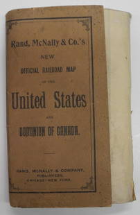
Sold2024Rand, McNally & Co.'S New Official Railroad Map of the United States And Dominion of CanadaTitle:Rand, McNally & Co.'S New Official Railroad Map of the United States And Dominion of Canada Publication Date: 1903 Cartographer:RAND, MCNALLY & CO. Publisher: RAND, MCNALLY & CO. Height: 30 WidtSee Sold Price
Sold2019Colton's Virginia Map [Southern States]Colton's Virginia Map; Delaware on the right, Maryland on the left. J. H. Colton Cartographer. Published by J. H. Colton, New York. Stamped 'Entered according to Act of Congress in the Year 1855 by J.See Sold Price
Sold2022Pre-Civil War school atlas map of East Coast states, 1849Very nice map of East Coast states showing Virginia fourteen years before West Virginia becomes a state. Nice example with full original hand coloring. No. 4 Virginia, North Carolina, South Carolina,See Sold Price
Sold2017J.T. Lloyd Wall Map of U.S. & Canada"Lloyds New Map of the United States, the Canadas and New Brunswick" dated 1863. 39" high, 57 1/2" wide. Toned throughout, scattered edge losses and small tears, tear with old tape repair upper left,See Sold Price
Sold2019ANTIQUE MAP OF VIRGINIA & SURROUND STATE PARCELSANTIQUE MAP OF VIRGINIA & SURROUND STATE PARCELS / UNFRAMEDSee Sold Price
Sold2022Official Map of Chicago Zoological Park - United States - The Brookfield Zoo Map After Its OpeningMap of the U.S. showing California with other states whittled down to their proper sizes. All loyal native sons vill vouch for the accuracy of this map.Petley Studius. No place publication, 1954. ColoSee Sold Price
4 days LeftBrunk AuctionsJohn Mitchell - A Map of the British and French Dominions in North America, 1755-1757US$24,000
Oct 05Mega International AuctionMEI LANFANG PEONY THREE OFFICIAL MAP VERTICAL AXIS FINE MOUNTEDUS$750
4 days LeftTrillium Antique Prints & Rare BooksCarey, pub. 1796 - 3 Maps of States in North AmericaUS$75(1 bid)
2 days LeftMynt Auctions11/13/1948 Houston Cougars vs North Texas State Official Football ProgramUS$10
Nov 03Modern JewelryNEW 14K YELLOW GOLD TEXAS STATE MAP PENDANT 14K YELLOW GOLD NEW TEXAS STATE MAP PENDANT WEIGHT: 2gUS$260
Nov 03Modern JewelryNEW 14K YELLOW GOLD FLORIDA STATE MAP PENDANT 14K YELLOW GOLD NEW FLORIDA STATE MAP PENDANT WEIGHT:US$280


![[Map, Large] Lloyd's Map of the Southern States 1862: "Lloyd's Map of the Southern States Showing all the Railroads, their Stations & Distances… 1862." New York: J. T. Lloyd, [1862.] Colored by state. Large map, measured from neatlines 51.25" x 37". Co](https://p1.liveauctioneers.com/3532/154050/77745068_1_x.jpg?height=310&quality=70&version=1572759985)


![[MAPS & ATLASES]. COLTON, J.H. (1800-1893). Colton's New Topographical Map of The States Of: [MAPS & ATLASES]. COLTON, J.H. (1800-1893). Colton's New Topographical Map of The States Of Virginia, Maryland and Delaware, Showing Also Eastern Tennessee & Parts Of Other Adjoining States. New York:](https://p1.liveauctioneers.com/197/265299/138516337_1_x.jpg?height=310&quality=70&version=1666051328)


![Colton's Virginia Map [Southern States]: Colton's Virginia Map; Delaware on the right, Maryland on the left. J. H. Colton Cartographer. Published by J. H. Colton, New York. Stamped 'Entered according to Act of Congress in the Year 1855 by J.](https://p1.liveauctioneers.com/5755/154409/77936948_1_x.jpg?height=310&quality=70&version=1573094011)


![[CIVIL WAR]. Group of Illustrated Histories and Atlases. 18... (1 of 10)](https://p1.liveauctioneers.com/928/342606/186002948_1_x.jpg?height=282&quality=70&version=1725643038)


![1891 Rand McNally Oregon [verso] Nevada -- Oregon [verso] Nevada (1 of 2)](https://p1.liveauctioneers.com/5584/343693/186665657_1_x.jpg?height=282&quality=70&version=1726603887)


