Sold2021Tallis, John (Pub) 1852 Map. BrazilSteel Engraved Map with Original Outline Hand Color Published 1852-56 by John Tallis, London for "The Universal Pronouncing Dictionary" by Thomas Wright. Drawn & Engraved by John Rapkin. Centre fold aSee Sold Price
Sold2021Findlay, Alex C1835 Antique Map. BrazilSteel Engraved Map Published C1835 by Thomas Kelly, London for "A New and Universal English Dictionary" by the Rev. James Barclay. Maps Drawn & Engraved by Alexander Findlay. Paper Size: 10.5 x 8 inchSee Sold Price
Sold2019Brazil. North oriented to the right. With cannibals.Reserve Reduced! Title/Content of Map: Brazil. North oriented to the right. With cannibals. Date: 1598/99. Cartographer: Ruscelli Size: 11x9” Provenance: Venice. Reserve: $300.00 Jasper52 negotiatesSee Sold Price
Sold2016John Cary: Brazil & Buenos Aires 1815Map: Brazil & Buenos Aires Publishing: John Cary Date: 1815 Size: 11 x 14 inches Original copper engraving John Cary (1754-1835) was an English cartographer who is known for his maps, globes, and hisSee Sold Price
Sold2019Brazil, Uruguay, Paraguay and Argentina.Title/Content of Map: Brazil, Uruguay, Paraguay and Argentina. Date 1863 Cartographer: By Johnson & Ward. From, Johnson’s New Illustrated Family Atlas Size: 18x14”. Provenance: New York. Not tearsSee Sold Price
Sold2017Blaeu Map of BrazilMaritima Brasiliae Universa. Joan Blaeu (1596-1673). Engraved map with original color in part. Amsterdam: Blaeu, 1647. 21 x 24 1/2 inches sheet, 32 1/2 x 36 inches framed. This separately issued and rSee Sold Price
Sold2018Hilde Weber for Osirarte Map of Brazil tableHilde Weber (1913-1994) for Osirarte Map of Brazil table Brazil, 1946 painted ceramic, cherry signed 'Osirarte Ex. Hilde' and 'Drusilla Aden S. Paolo 1946' 32 3/4"w x 21"d x 19"hSee Sold Price
Sold2020Petrus Bertius Map of Africa 1640Petrus Bertius (1565-1629), "Carte de L'Afrique," Paris, 1640. This highly detailed map of Africa features African animals, including lions and elephants, throughout the continent, and ships and sea mSee Sold Price
Sold20221719 de Fer Map of Brazil -- Le Bresil dont les Cotes sont Divisees en Capitaineries Dresse sur lesTitle: 1719 de Fer Map of Brazil -- Le Bresil dont les Cotes sont Divisees en Capitaineries Dresse sur les Dernieres Relations des Filibustiers et Fameux Voyageurs . . . Cartographer: N de Fer Year /See Sold Price
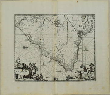
Sold20221650 Blaeu Map of Brazil -- BrasiliaTitle: 1650 Blaeu Map of Brazil -- Brasilia Cartographer: J Blaeu Year / Place: 1650, Amsterdam Map Dimension (in.): 15.2 X 19.5 in. This is a magnificent large map of most of Brazil, Guiana and UruguSee Sold Price
Sold2019Rare 1st issue of Hondius' Brazil map, 1629Heading: Author: Hondus, Jodocus Title: Novus Brasiliae Typus Place Published: Amsterdam Publisher:Jodocus Hondius excudit Date Published: 1629 Description: Copper-engravedSee Sold Price
Sold2017Blaeu: Antique Map of Brazil, 1634Map: Novus Brasiliae Typus Cartographer: Blaeu Place & Date: Amsterdam / 1634 (circa) Size: 19 1/2" x 15" Condition: b&w; cleaned; some minor spotting; centerfold reinforced Blaeu's superb, Hondius-deSee Sold Price
Sold20231671 Ogilby Map of Brazil -- BrasiliaTitle: 1671 Ogilby Map of Brazil -- Brasilia Cartographer: J Ogilby Year / Place: 1671, London Map Dimension (in.): 11.3 X 13.8 in. This is an excellent map of the eastern part of Brazil. There is anSee Sold Price
Sold2022Antique Framed Engraved Map of Brazil"Office of Pernambuco Northern Region" (caption translation). This engraving of a map of Brazil includes an inset image showing a sugar plantation and enslaved people engaged in various tasks. In theSee Sold Price
Sold2017Bertius, Map of SpitsbergDelineatio Spitsbergiae. Petrus Bertius (1565-1629). from Tabularum geographicarum contractarum libri septem. Miniature engraved map with original hand color. Amsterdam: Jodocus Hondius, 1618. 4 3/4 xSee Sold Price
Sold2016Map of Brazil by Pierre van der AaMap: Le Bresil, Serviant Les Nouvelles Observations De Messrs. De L'academie Royale Des Sciences, Etc. Augmenties De Nouveau Maker: Pierre van der Aa, A. Leide Size: Quarto - 9 inches high x 11.8 inchSee Sold Price
Sold2017Janssonius: Antique Map of Brazil, 1630Map: Accuratissima Brasiliae Tabula." European Depiction of Cannibalism in 1600'S Publication Date: 1630 ca. Authors: JOANNES JANSSONIUS, JANSSON, JANS Publisher: JOANNES JANSSONIUS Size: Folio – 14See Sold Price
Sold2021MAP, Itamaraca, Brazil, MontanusItamaraca, Brazil. Arnoldus Montanus, I. Tamaraca, from De Nieuwe en Onbekende Weereld, 1671 (circa). Black & White. This fine view shows the Dutch Fort Oranje on the island of Itamaraca, off the nortSee Sold Price
Sold20201850 Tallis Map of Brazil -- BrazilTitle/Content of Map: 1850 Tallis Map of Brazil -- Brazil Cartographer: J Tallis Year/Place: 1850, London Size: 13.6 X 9.6 in. This is rather attractive and decorative map of Brazil. It features fiveSee Sold Price
Sold2017d'Anville: Antique Map of Brazil, 1758Map: Suite Du Bresil Publication Date: 1758 Authors: DIDOT, ANVILLE, J. B. B. d' Publisher: DIDOT Size: Octavo – 9.25 H x 6.60 W Inches "depuis la Baye de Tous les Saints jusqu'a St. Paul pour serviSee Sold Price
Sold20201612 Bertius Map of Madagascar -- I.S. LauretijTitle/Content of Map: 1612 Bertius Map of Madagascar -- I.S. Lauretij Cartographer: P Bertius Year/Place: 1612, Amsterdam Size: 3.4 X 4.8 in. This is a very nice smaller map of Madagascar with north oSee Sold Price
Sold2018Bellin: Suite of 3 Antique Brazil Maps, 1756Title/Content of Map: Carte du Bresil Prem. Partie [and] Suite du Bresil Depuis la Baye de Tous les Saints jusqu'a St. Paul [and on the same sheet] Suite du Bresil Cartographer: Bellin Place & Date: PSee Sold Price
Sold2024Churchill & Nieuhof 1744 Folio Map. Brasilia BrazilFolio Copper Engraved Map Published 1704-47 [1744] London for "A Collection of Voyages and Travels..." By Awnsham & John Churchill. The work based mostly on the Voyages and Travels into Brasil and theSee Sold Price
Sold20241816 Map of Brazil From Mathew Carey AtlasShows the territory of Brazil from the mouth of the Amazon to the Rio de la PlataSee Sold Price
3 days LeftJasper52S AMERICA 'Brazil, Bolivia, Peru, & Ecuador' Bolivia w/ littoral.LOWRY 1862 mapUS$8
3 days LeftJasper52S AMERICA 'Brazil, Bolivia, Peru, & Ecuador' Bolivia w/ littoral.LOWRY 1863 mapUS$8
2 days LeftJasper521640 Gerritsz/De Laet Map of Brazil -- Provincia de Brasil cum Adiacentibus ProvinciisUS$320
2 days LeftJasper521822 MAP of BRAZIL GEOGRAPHICAL STATISTICAL HISTORICAL # 48 antique 17.5 x 21.5"US$75
3 days LeftJasper52AMAZONIA. Showing Indian tribes. Guyana Surinam Brazil. Recife. SDUK 1844 mapUS$10
3 days LeftJasper52SOUTH AMERICA NW. Colombia Venezuela Ecuador Peru Bolivia Brazil. Lima 1907 mapUS$8
3 days LeftJasper52NW SOUTH AMERICA. Colombia Venezuela Ecuador Peru Bolivia Brazil. Lima 1907 mapUS$10
3 days LeftJasper52AMAZONIA & ANDEAN STATES. Colombia includes Panama. Venezuela. LETTS 1884 mapUS$20
3 days LeftJasper52PERU, BOLIVIA & part of Brazil. Indian tribes. Bolivian Litoral. SDUK 1844 mapUS$10
3 days LeftJasper52BOLIVIA, PERU with part of Brazil. Indian tribes Bolivian Litoral SDUK 1844 mapUS$10
3 days LeftJasper52BOLIVIA & PERU with a part of Brazil. Bolivia Litoral / sea coast. SDUK 1857 mapUS$10
3 days LeftJasper52AMAZONIA. Showing Indian tribes. Guyana Surinam Brazil. Recife. SDUK 1844 mapUS$10
3 days LeftJasper52BOLIVIA & PERU with a part of Brazil. Bolivia Litoral / sea coast. SDUK 1851 mapUS$15
3 days LeftJasper52AMAZONIA. Showing Indian tribes. Guyana Surinam Brazil. Recife. SDUK 1851 mapUS$15
2 days LeftJasper521723 Dampier Map of Voyages to Brazil, Australia and Eat Indies -- Voyage du Cap. Dampier a la N.US$280
3 days LeftJasper52Amér Mér Colombie & Brésil 9 Peru Colombia Amazonas Brazil VANDERMAELEN 1827 mapUS$70
3 days LeftJasper52Carte du Paraguay et des Pays voisins'. Uruguay Brazil. BELLIN/SCHLEY 1772 mapUS$70
3 days LeftJasper52Amér Mér. Colombie #5 Eastern Colombia. NW Amazonas Brazil VANDERMAELEN 1827 mapUS$100
3 days LeftJasper52AMAZONIA.Showing "El Dorado?", missions & tribes. Brazil Ecuador.SDUK 1844 mapUS$130
Featured3 days LeftJasper52SOUTH AMERICA. Bolivia includes Acre, now in Brazil. JOHNSTON 1900 old mapUS$10


![Bellin: Suite of 3 Antique Brazil Maps, 1756: Title/Content of Map: Carte du Bresil Prem. Partie [and] Suite du Bresil Depuis la Baye de Tous les Saints jusqu'a St. Paul [and on the same sheet] Suite du Bresil Cartographer: Bellin Place & Date: P](https://p1.liveauctioneers.com/5584/114563/58815206_1_x.jpg?height=310&quality=70&version=1514941693)
![Churchill & Nieuhof 1744 Folio Map. Brasilia Brazil: Folio Copper Engraved Map Published 1704-47 [1744] London for "A Collection of Voyages and Travels..." By Awnsham & John Churchill. The work based mostly on the Voyages and Travels into Brasil and the](https://p1.liveauctioneers.com/3952/320085/171971821_1_x.jpg?height=310&quality=70&version=1708266709)


