Sold2018Mercator map of the North Pole 1619Heading: Author: Mercator, Gerard Title: Septentrionalium Terrarum descriptio Place Published: Amsterdam Publisher: Date Published: 1595-[1619] Description: Copper-engravedSee Sold Price
Sold2018Mercator: Antique Map of Crete, 1619Title/Content of Map: Candia cum Insulis aliquot circa Graeciam. Cartographer: Gerard Mercator Place & Date: Amsterdam / 1619 Size: 19" x 13 1/2" Condition: wash color; overall age toning A splSee Sold Price
2021Michael Mercator RARE Antique Map of the AmericasAntique map of "America and New India" (America Sive India Nova) produced by Michael Mercator (c. 1567-1600), Gerard Mercator’s grandson. Hand colored engraved map. Duisburg, 1595 (Amsterdam, 1See Sold Price
Sold2018Mercator/Hondius: Corsica and SardiniaMap: Corsica/Sardinia Cartographer: Gerard Mercator / Jodocus Hondius Place/Date: Amsterdam / 1606 Size: 18 1/8" x 13 3/8" Condition: full color; light overall age toning otherwise a beautifully preseSee Sold Price
Sold2022MAP: Gerard Mercator (1512-1594), "Asiae VI. Tab," hand-colored engraving of Ptolemaic map of theMAP: Gerard Mercator (1512-1594), "Asiae VI. Tab," hand-colored engraving of Ptolemaic map of the Middle East, from the 1595 edition of Mercator's Geographia, based upon the works of Claudius PtolemySee Sold Price
Sold2020Gerardus Mercator Map of Macedonia ca. 1595Gerardus Mercator (1512–1594), "Macedonia Epirus et Achaia," Amsterdam, ca. 1595. Hand colored map of Macedonia and the surrounding areas. This map features beautifully executed topographical dSee Sold Price
Sold2018Mercator/Hondius: Corsica and Sardinia, 1606Reserve Reduced! Map Title: Corsica/Sardinia Cartographer: Gerard Mercator / Jodocus Hondius Place/Date: Amsterdam / 1606 Size: 18 1/8" x 13 3/8" Condition: full color; light overall age toning otherwSee Sold Price
Sold201916th century Natolie Sive Asie Minor Mercator Map16th Century fine early map of Turkey in Asia, published in Amsterdam by Gerard Mercator. Strapwork cartouche at lower right. Two more cartouches, one shows scales, the other has a Latin inscription.See Sold Price
Sold20241630 Natolie Sive Asia Minor Mercator Mapearly map of Turkey in Asia, published in Amsterdam by Gerard MercatorSee Sold Price
Sold2023America - Mercator/Hondius Atlas Minor 1609Heading: (America) Author: Mercator, Gerard / Hondius, Jodocus Title: Americae Descrip. Place Published: Amsterdam Publisher: Date Published: 1609 Description: Copper-engraved map.See Sold Price
Sold2018Hondius, Joducius and Mercator, Gerard. Cyprus Ins:from Atlas Sive Cosmographicae, 1619 or somewhat later, copperplate engraving with hand color showing a large map of Cyprus below which are inset maps of Lemnos, Chios, Lesbos, Euboea, Kythera, and RhSee Sold Price
Sold2020Hondius Map of MoroccoHONDIUS, Jodocus (1563-1612) / MERCATOR, Gerard (1512-1594). [Morocco] Fessae et Marocchi Regna. Engraving with original hand color. Amsterdam, c. 1606 or later. 17 3/4" x 21" sheet. Comparable: Old WSee Sold Price
Sold2018Hondius, Joducius and Mercator, Gerard. Cyprus Ins:from Atlas Sive Cosmographicae, 1619 or somewhat later, copperplate engraving with hand color showing a large map of Cyprus below which are inset maps of Lemnos, Chios, Lesbos, Euboea, Kythera, and RhSee Sold Price
Sold2018After Michael Mercator(Dutch, late 16th/early 17th century) Map of the Americas, entitled: [America sive India Nova ad magnae Gerardi Mercatoris aui Uiniversalis imitationem in compendium redacta], 1595-1619, modern facsimSee Sold Price
Sold2016Mercator map of RussiaHeading: Author: Mercator, Gerard / Jodocus Hondius Title: Russia cum Confinijs Place Published: Amsterdam Publisher: Date Published: 1609-[1628-33] Description: Copper-engSee Sold Price
Sold202118th C Large Handcolored Mercator Map GermanyLarge beautifully handcolored map of Braunswyck and Meydburg after Gerard Mercator circa 1640, this being an 18th century restike.. Printed at Amsterdam. Measures 23 x 19". Fine, reinforced central veSee Sold Price
Sold2024Gerard Mercator (Belgian 1512 - 1594) and Rumold Mercator (Belgian 1545 - 1599)Gerard Mercator (Belgian 1512 - 1594) and Rumold Mercator (Belgian 1545 - 1599) "Orbis Terrae Compendiosa Descriptio", circa 1595 Engraved and hand colored map 14 1/2" x 19 3/4" Condition: aging, yellSee Sold Price
Sold2017Mercator: Map of Japan with Korea, 1630Title: Iaponia Map maker: Gerard Mercator & J.E. Cloppenburgh, Pieter Van Den Keere Place and Year: Amsterdam, 1630 Dimensions: 18.8 x 24.6 cm (7.4 x 9.7 in) Technique: Copperplate engraving Coloring:See Sold Price
Sold2020Bohemia. (Czech Rep) 1613- 1619. By Gerard MercatorTitle: Bohemia. (Czech Rep) 1613- 1619. By Gerard Mercator Date/Period: 1613- 1619 Materials: Copperplate engraved Size: 21x16 inches Description: Published in ‘Atlas Sive Cosmographia ‘, AmsterdaSee Sold Price
Sold2020Mercator & Hondius C1610 Map of Alsace, France (Fault)"Alsatia Inferior" Copper Engraved Map Published 1607-10, Amsterdam & Dordrecht for "Atlas Minor" by Jodocus Hondius & Gerard Mercator. Paper Size: 8.5 x 7 inch (22 x 18cm) Large chip at bottom, slighSee Sold Price
Sold202216th / 18th C. European Maps of New Spain (2)**Originally Listed At $300** Cartographer: Gerard Mercator. "Hispaniae Novae Nova Descriptio" Published by I.E. Cloppenburgh, Amsterdam, 1632. AND Stieler's "Mexico Und Centro-America …" Gotha, 182See Sold Price
Sold2015EUROPAE. [Ortelius, Ca. 1584-1612.] Map.[Ortelius, Abraham] EUROPAE. [C. 1584-1612.] Engraved map by Ortelius based on Jenkinson’s Russia map and Gastaldi’s maps of Africa and Asia, Gerard Mercator’s 1564 map of Britain, a map of ScanSee Sold Price
Sold2023Four Antique Maps, China & Asia, Gerard Mercator, Jacques BellinDescription: To include a 1628 map of China and Asia by from the Gerard Mercator Atlas Minor (framed), a 1748 copper engraved Jacques Bellin map of Cathay (Northern China & Southern Mongolia), a 1749See Sold Price
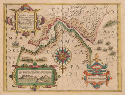
Sold2017Mercator: Strait of Magellan, Terra del Fuego, 1613Exquisita & magno aliquot mensium periculo Lustrata et iam retecta Freti Magellanici Facies . . . By: Gerard Mercator. Date: 1613 / Amsterdam. Dimensions: 14 x 18 inches (35.5 x 45.7 cm) This is an auSee Sold Price
Featured12 hrs LeftJasper521866 Johnson Map of Holland and Belgium - Johnson's Holland and BelgiumUS$40
11 hrs LeftJasper521772 GREEK BIBLE NEW TESTAMENT antique BIBLIA LATIN text MAP NOVUM TESTAMENTUMUS$360
4 days LeftTrillium Antique Prints & Rare BooksDe Jode, Rare, pub. 1593 - Electors of the Holy Roman Empire (Ordines Sacri Romani Imp: Ab OttoneUS$100(1 bid)
3 days LeftMarques Dos Santos, LdaF.DE WIT - 'Regni Poloniae et Ducatus Lithuaniae Voliniae, Podoliae...'€300
May 30NY Elizabeth D. BLONDEL GENEALOGIAE FRANCICAE VELLUM ANCIENT FOLIO MAPS 1654 HISTORY OF FRANCEUS$50


![Mercator map of the North Pole 1619: Heading: Author: Mercator, Gerard Title: Septentrionalium Terrarum descriptio Place Published: Amsterdam Publisher: Date Published: 1595-[1619] Description: Copper-engraved](https://p1.liveauctioneers.com/642/122092/62169135_1_x.jpg?height=310&quality=70&version=1526256630)


![Hondius Map of Morocco: HONDIUS, Jodocus (1563-1612) / MERCATOR, Gerard (1512-1594). [Morocco] Fessae et Marocchi Regna. Engraving with original hand color. Amsterdam, c. 1606 or later. 17 3/4" x 21" sheet. Comparable: Old W](https://p1.liveauctioneers.com/1968/169571/85465312_1_x.jpg?height=310&quality=70&version=1590242353)

![After Michael Mercator: (Dutch, late 16th/early 17th century) Map of the Americas, entitled: [America sive India Nova ad magnae Gerardi Mercatoris aui Uiniversalis imitationem in compendium redacta], 1595-1619, modern facsim](https://p1.liveauctioneers.com/33/131921/67027348_1_x.jpg?height=310&quality=70&version=1543252578)
![Mercator map of Russia: Heading: Author: Mercator, Gerard / Jodocus Hondius Title: Russia cum Confinijs Place Published: Amsterdam Publisher: Date Published: 1609-[1628-33] Description: Copper-eng](https://p1.liveauctioneers.com/642/93238/47584241_1_x.jpg?height=310&quality=70&version=1472923400)


![EUROPAE. [Ortelius, Ca. 1584-1612.] Map.: [Ortelius, Abraham] EUROPAE. [C. 1584-1612.] Engraved map by Ortelius based on Jenkinson’s Russia map and Gastaldi’s maps of Africa and Asia, Gerard Mercator’s 1564 map of Britain, a map of Scan](https://p1.liveauctioneers.com/179/82189/42599765_1_x.jpg?height=310&quality=70&version=1447864785)


![[MAP]. ORTELIUS, Abraham. Aevi Veteris, Typus Geographicus. 1601. (1 of 3)](https://p1.liveauctioneers.com/197/329395/177650532_1_x.jpg?height=282&quality=70&version=1715364962)


