Sold202218th & 19th C. MAPS OF ASIA (3 MAPS)Includes: 2 maps by John Tallis & Co. London / New York, ca. 1850, both matted and framed, including: (1) MAP OF ASIA. Hand colored engraved map. 5 hand colored vignettes. H. 10.25", W. 12.75"; (2) MASee Sold Price
Sold2022THREE HAND-COLORED MAPS OF ASIATHREE HAND-COLORED MAPS OF ASIA1) “Asia”, from a miniature Ortelius atlas, Brescia, after 1598. 3.75” x 5” sight. Framed 9” x 10.5”.2) “A New Map of Asia̶See Sold Price
Sold2022LARGE HAND-COLORED MAP OF ASIA 20” x 24” sight. Framed 29.5” x 33.5”.LARGE HAND-COLORED MAP OF ASIA“Asia, Concinnata Secundum Observationes Academia Regalis Scientiarum et nonnullas alias, et juxta annotations recentissimas per G. de L'Isle”, Tobias ConradSee Sold Price
Sold20211631 Latin Hand Colored Map of Asia1631 Latin Hand Colored Map of Asia framed Framed Measures 18 1/4 x 23 1/2See Sold Price
Sold2021Large hand colored map of Asia, 1875Large vintage map of Asia in the not-often seen hand-colored version. Most likely drawn by A. K. Johnston, and appearing the very scarce Jones and Hamilton Atlas of the World Illustrated, published 18See Sold Price
Sold2018EARLY HANDCOLORED MAP OF ASIA, FROM GROUP WE AREEARLY HANDCOLORED MAP OF ASIA, FROM GROUP WE ARE SELLING. CAN'T SEE A DATE, FRAMED AND MATTED. MEASURES 20" X 23". NICE CONDITION, LOOKS LIKE SMALL TEAR IN UPPER LEFT CORNER BY THE MATTING.See Sold Price
Sold2020(2) HANDCOLORED MAPS OF ASIABurma, Siam, French Indo-China and Straits Settlements and Physical Map of Asia . Dimensions: H 9.75" x W 12.75" Condition: Folding, toning and a tear to the middle of the Map of Asia.See Sold Price
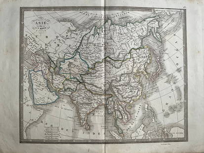
Sold2023"Africa" by John Luffman & "Asia" Antique Handcolored Maps"Africa" by John Luffman & "Asia" Antique Handcolored Maps.See Sold Price
Sold2020Gerardus Mercator Map of Asia 1613Gerardus Mercator (1512-1594), "Asia ex magna orbis terre descriptione Gerardi Mercatoris desumpta studio et industria G.M. Iunioris," Amsterdam, ca. 1613. Hand colored map of Asia. Dimensions: Sight;See Sold Price
Sold20231700s MAP of ASIA MINOR ARMENIA SYRIA SYCILY PERSIA antiqueMap of Asia Minor early 18th century hand colored Size 14 1/2 by 18 3/4" Very good condition Reserve: $160.00 Shipping: Domestic: Flat-rate of $25.00 to anywhere within the contiguous U.S. InternaSee Sold Price
Sold2023Map of Asia toward the end of the 18th century – PerthesFascinating hand-colored map depicts Asia at the end of the 18th century. The British had established themselves in India and the Chinese Empire was under Manchu control. Also depicts Southeast Asia iSee Sold Price
Sold2021LEVASSEUR: HAND-COLORED ENGRAVED MAP OF ASIAHand-Colored Engraved Map of Asia, Published in the 'Atlas Universel Illustre' in Paris in 1850 by Levasseur. Printed by Lemercier. The verso of the frame mounted with a certificate of authenticity. PSee Sold Price
20241839 Asia Map by MoninTitle: 1839 Asia Map by Monin Date/Period: 1839 Materials: Hand colored, engraved Size: 17 1/2 x 12 1/2" This map is an interesting depiction of Asia in 1839 when the continent was still largely unexpSee Sold Price
Sold2024Prichard & Walker 1844 Hand Colored Map. Ethnological Map of AsiaHand Colored Steel Engraved Map Published 1844, London for "Researches Into The Physical History Of Mankind" by James Cowles Prichard. Engraved by J & C Walker. Folds as issued. Paper Size: 16.5 x 14See Sold Price
Sold2015Tabula Indiae Orientalis byFrederick de Wit Amsterdam, 1662, de Wit's attractive hand-colored map of Southeast Asia, engraved by Joannas Lhulier, this map served as a prototype for Speed's map of the East Indies, cartouche withSee Sold Price
Sold2018Map of Asia by Seutter, 1740Title/Content of Map: Asia by Seutter Date Printed: c1740 Cartographer: Matthaus Seutter Material/Medium: Paper Size: 23" x 19" Provenance: New York Original hand colored copperplate engraved. PublishSee Sold Price
Sold20151764 JACQUES NICHOLAS BELLIN MAP ROYAUMES DE SIAMA 1764 engraved and hand-colored map depicting South Asia, titled, "Carte des Royaumes de Siam, de Tunquin, Pegu, Ava Aracan, &c.", published by Jacques Nicolas Bellin (1703-1772, France) on laid, watSee Sold Price
Sold2017Homann Heirs: Antique Map of Asia, 1746Map: Asia Date Printed: 1746 Cartographer: Homann Heirs Material/Medium: Paper Size: 23 3/4" x 21" Printed in Nuremberg. Hand colored copperplate engraved. Beautiful baroque style cartouche. Please noSee Sold Price
Sold2021H. Moll C. 1730 Map of AsiaDESCRIPTION: H. Moll c. 1720 Map of Asia. Dedicated to the Right Honorable William, Lord Cowper, Lord High Chancellor of Great Britain. Hand colored, completed in three parts. MEASUREMENTS: 40 " wideSee Sold Price
Sold2020Nicolas Sanson Map of AsiaNicolas Sanson (1600-1667) "L'Asie divisee en ses Principales Regions, et ou se peuvent voir l'estendue, Des Empires, Monarchies, Royaumes, et Estats," Paris: Jaillot, ca. 1719. Hand colored map of AsSee Sold Price
Sold2019Rare map of Asia 1717 by Feuille, AmsterdamRare map of Asia 1717 by Feuille, Amsterdam 7.6x10.6” Hand colored. Note* damage on Persia. Reserve: $80.00 Shipping: Domestic: Free shipping to anywhere within the contiguous U.S. International: FoSee Sold Price
Sold2021UNFRAMED ANTIQUE MAP OF ASIA MINOR , HOMANN HEIRS, 1743"Carte de L'Asie Minevre ou de la Natolie et du Pont Evxin Tiree des Voyages et des Observations de Anciens et Modernes,...Heretiers de Homann. Nuremb.". Hand colored copperplate engraving. Unframed,See Sold Price
Sold2015Pelton's 1852 Outline Map of AsiaHand colored lithograph, with both original ebonized wood hangers. Published by Sower & Barnes, Philadelphia, with insert map of Palestine. 79" x 67".See Sold Price
Sold2021J. Hinton 1762 An Improved Map of AsiaHand colored map on wove paper "An improved map of Asia : with all the discoveries that have been made to the present time" by John D. Hinton (d.1781) published by the Universal Magazine, J. Hinton, NSee Sold Price
Jun 08Connoisseur AuctionsEarly 1900's Railway Service Map, Illinois, Ohio, Indiana, Kentucky, TennesseeUS$20(1 bid)
Jun 08Leon GalleryAbraham Ortelius (1527 - 1598) - Indiae Orientalis (Philippines/China/ India/ Southeast Asia)₱200,000
Jun 08Early American History Auctions1836 Hand-Colored Map, Country Twenty Five Miles Round The City Of New-York Published by D.S. StoneUS$260
Jun 08Early American History Auctions1753 Map of the County of Lancaster Divided into its Hundreds, by Royal Mapmaker Emanuel BowenUS$280
Jun 09Worthington GalleriesFirst Edition Hand-colored Map THE NORTH RIDING OF YORKSHIRE by Robert MordenUS$50
Jun 08Early American History Auctions1776 Map, PARTIE ORIENTALE DU CANADA, AVEC LA NOUVELLE ANGLETERRE, L'ACADIE... by P. Santini, FramedUS$950