Sold20201633 Engraved Plan Siege of DunboyRare engraved plan from "Pacata Hibernia..", printed in 1633 showing the castle of Dunboy during the perioed of Tyrone's rebellion. Matted with image 11.75 x 15". Fine. Reserve: $100.00 Shipping: DomeSee Sold Price
Sold202417TH C. ANTIQUE MAP SIEGE OF LA ROCHELLE, FRANCE, FRAMED"Seige et Reddition de La Rochelle, Octobre 1628", handcolored engraving on wove paper, Claes Jansz. Visscher (II), (workshop of), Germany, 1627 - 1629. In gilt molded frame, matted under UV non-glareSee Sold Price
Sold2022Rare map Siege of Charleston in Amer. Rev. War, Marshall 1832Rare plan of the Revolutionary War Siege of Charleston in South Carolina. From John Marshall’s 1832 edition of the Life of Washington. Covers the area comprising Charleston Harbor and parts of the CSee Sold Price
Sold2022Rapkin, John 1858 Antique Map. Siege of Sebastopol, CrimeaSteel Engraved Map Published 1858 by the London Printing and Publishing Co., London for "The History Of The War With Russia: Giving Full Details Of The Operations Of The Allied Armies" by Henry TyrrelSee Sold Price
Sold20191633 Hondius Map od Bermuda -- Mappa AestivarumReserve Reduced! Title/Content of Map: 1633 Hondius Map od Bermuda -- Mappa Aestivarum Insularum, alias Barmudas dictarum… Date: 1633, Amsterdam Cartographer: H Hondius Size: 15.5 X 20.5 in. This isSee Sold Price
Sold20221720 Homann Map of Siege of Belgrade -- Neu-Geographisch Vorgestelltes Ungarisches Kriegs-TheatrumTitle: 1720 Homann Map of Siege of Belgrade -- Neu-Geographisch Vorgestelltes Ungarisches Kriegs-Theatrum in Servien und dem Bannat Temeswar ... 1716 und 1717 Cartographer: J Homann Year / Place: 1720See Sold Price
Sold2017Late 16th Century Maps, Incl. Siege of La Rochelle &Two maps on one sheet. Hand-colored map of Ghent (approx. 8.5 x 11 in.), tipped onto reverse side of page with map of the Siege of La Rochelle (approx. 8.25 x 11 in. plate size). Both maps printed witSee Sold Price
Sold20201633 Engraving Pacata Hibernia DunboyMatted engraving from the 1633 edition of "Pacata Hibernia", printed at London illustrating the area of the seige of Dunboy Castle. Fine, engraved area measures 11.5 x 15". Reserve: $150.00 Shipping:See Sold Price
Sold20231893 Civil War Map of Siege of Vicksburg and Vicksburg to Jackson, Miss. -- …Siege of Vicksburg …Title: 1893 Civil War Map of Siege of Vicksburg and Vicksburg to Jackson, Miss. -- …Siege of Vicksburg … [with] …Country Between Milliken's Bend, LA and Jackson, Miss… [Plate XXXVI] CartographSee Sold Price
Sold2021Rapkin, John 1857 HC Map of Siege of Sebastopol, CrimeaHand Colored Steel Engraved Map Published 1857, London for "England's Battles by Sea and Land..." by Lieut-Colonel Williams. Centre fold as issued. Drawn & Engraved by John Rapkin. Paper Size: 14 x 10See Sold Price
Sold2021Rapkin, John 1857 HC Map of Siege of Sebastopol, CrimeaHand Colored Steel Engraved Map Published 1857, London for "England's Battles by Sea and Land..." by Lieut-Colonel Williams. Centre fold as issued. Drawn & Engraved by John Rapkin. Paper Size: 14 x 10See Sold Price
Sold20241893 Civil War Maps of Vicksburg and Jackson Areas and Battles -- …Defenses of Vicksburg,Title: 1893 Civil War Maps of Vicksburg and Jackson Areas and Battles -- …Defenses of Vicksburg, Miss… [with] …Map of Siege of Jackson, Miss… [with] …vicksburg and ViciniSee Sold Price
Sold201818th C. Spanish Oil, Map of the Siege of BarcelonaContinental School, likely Spanish, late 18th century Overhead landscape painting depicting a stylized map view of Barcelona as seen in 1705, bearing inscription loosely translating to "The Viceroy VeSee Sold Price
Sold20221633 Hondius Map of Bermuda -- Mappa Aestivarum Insularum, alias Barmudas dictarum…Title: 1633 Hondius Map of Bermuda -- Mappa Aestivarum Insularum, alias Barmudas dictarum… Cartographer: H Hondius Year/Place: 1633, Amsterdam Dimensions: 15.5 X 20.5 in. Description: This is aSee Sold Price
Sold20181573 Map of the Siege of La Rochelle -- [Untitled]Title/Content of Map: 1573 Map of the Siege of La Rochelle -- [Untitled] Siege of La Rochelle Date Printed: 1573 c. Cartographer: Anonymous Size: 9 x 11.1 in. A very interesting map of the Siege of LaSee Sold Price
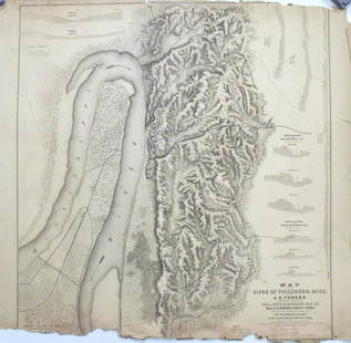
Sold2017Map of the Siege of Vicksburg, MississippiMap: Map of the Siege of Vicksburg, Mississippi Description: This large battle map identifies Union and Confederate entrenchments. It is very detailed, showing the roads, streets, houses, railroads, vSee Sold Price
Sold20211762 Map of the Siege of HavanaAuthor: Kitchin Title: 1762 Map of the Siege of Havana Materials: Ink on Paper Dimensions: 7"X4.5" Description: Map of the siege of Havana and the Moor Castle dated 1762. Engraved and published by ThoSee Sold Price
Sold2018German Historic War Maps, Towns, and Sieges17th and 18th Century German Cartography School, Various Maps showing Battles, Settlements, Wars at German, Swedish, and Dutch Cities, copperplate engravings, approximately 12 x 14.5 inches, approximaSee Sold Price
Sold2016Siege of Turin Map and EngravingEngraving on laid paper with watercolor. Later laid to paperboard. The battle and Siege of Turin in 1706 depicted by Johann August and Jeremias Wolff. Framed under glass not inspected out of the frameSee Sold Price
Sold2021Siege of Vicksburg Map (Civil War)Siege of VicksburgThe Siege of Vicksburg The siege of Vicksburg (May 18 – July 4, 1863) was the final major military action in the Vicksburg campaign of the American Civil War.See Sold Price
Sold2016Map of Bermuda, by Hondius 1633Map of Bermuda, by Hondius 1633. Original hand colored copper engraving. Showing the "tribes" that were granted by the gentleman onboard the shipwreck that force the European settlement of the island.See Sold Price
Sold2023Jefferys, Authentic Plan of the River St. Laurence - First StateJEFFERYS, Thomas (c. 1719 - 1771). An Authentic Plan of the River St. Laurence from Silleru to the Fall of Montmorenci with the operations of the Siege of Quebec... Engraved map with original hand colSee Sold Price
Sold2019Wilem J. Blaeu mapWilem J. Blaeu (Dutch 1571-1638)- Americae Nova Tabula- engraved map with hand-coloring, ca. 1633. 16 1/4 x 21 1/2''See Sold Price
Sold2019Blaeu map of North & South AmericaHeading: Author: Blaeu, Willem Title: Americae Nova Tabula Place Published: Amsterdam Publisher: Date Published: c.1633 Description: Copper-engraved map. 36x46.5 (14¼x18¼")See Sold Price
Jun 23Schilb Antiquarian Rare Books1977 JRR Tolkien 1st ed Silmarillion Lord of the Rings Middle Earth + MAPUS$155(7 bids)
3 days LeftDOYLE Auctioneers & AppraisersSet of Twelve Satirical Anthropomorphic Maps of EuropeUS$400(1 bid)
Jun 23Schilb Antiquarian Rare Books1848 Emory Military Reconnaissance 1ed California MAP Indians Texas New MexicoUS$4(4 bids)
Jun 23Schilb Antiquarian Rare Books1890 Livingstone 1ed In Darkest Africa Henry Stanley Emin Pasha Expedition MAPUS$145(8 bids)
1 day LeftDotDot Art Gallerychinese Ming Dynasty Xuande year embroidery map of ParadiseUS$3,000(1 bid)
3 hrs LeftCrescent City Auction GalleryPair of New Orleans Sanborn Fire Insurance Mock-Up Skeleton Maps of the French Quarter, 1910-1911,US$250
Jun 23Leonard Auction, a division of The Leonard CompanyEuropean and United States Map AssortmentUS$150
Jun 26University ArchivesSiege of Boston 1776 Receipt for Soldiers' Wages for Service in 1775 at the Start of the WarUS$200
Jun 25Freeman's | Hindman[Maps & Atlases] A New Map of North America, with the West India Islands...US$300
Jun 25Freeman's | Hindman[Maps & Atlases] Braun, Georg, and Frans Hogenberg: Londinum, Feracissimi Angliae...US$1,000
Jun 25Freeman's | Hindman[Philadelphia & Pennsylvania] Howell, Reading: A Map Of The State Of PennsylvaniaUS$3,500
Jun 23Schilb Antiquarian Rare Books1870 BEAUTIFUL Life of Jesus Christ Fleetwood Bible ART Miracles Jerusalem MapUS$92(5 bids)


![1893 Civil War Map of Siege of Vicksburg and Vicksburg to Jackson, Miss. -- …Siege of Vicksburg …: Title: 1893 Civil War Map of Siege of Vicksburg and Vicksburg to Jackson, Miss. -- …Siege of Vicksburg … [with] …Country Between Milliken's Bend, LA and Jackson, Miss… [Plate XXXVI] Cartograph](https://p1.liveauctioneers.com/5584/293457/155766038_1_x.jpg?height=310&quality=70&version=1687903812)


![1893 Civil War Maps of Vicksburg and Jackson Areas and Battles -- …Defenses of Vicksburg,: Title: 1893 Civil War Maps of Vicksburg and Jackson Areas and Battles -- …Defenses of Vicksburg, Miss… [with] …Map of Siege of Jackson, Miss… [with] …vicksburg and Vicini](https://p1.liveauctioneers.com/5584/325789/175390306_1_x.jpg?height=310&quality=70&version=1713301948)


![1573 Map of the Siege of La Rochelle -- [Untitled]: Title/Content of Map: 1573 Map of the Siege of La Rochelle -- [Untitled] Siege of La Rochelle Date Printed: 1573 c. Cartographer: Anonymous Size: 9 x 11.1 in. A very interesting map of the Siege of La](https://p1.liveauctioneers.com/5584/124870/63536014_1_x.jpg?height=310&quality=70&version=1531863645)


![[Quebec] - Jefferys, Thomas (1 of 1)](https://p1.liveauctioneers.com/94/330664/178342422_1_x.jpg?height=282&quality=70&version=1716466933)


![[Maps & Atlases] Speed, John: The Turkish Empire (1 of 2)](https://p1.liveauctioneers.com/65/332523/179335176_1_x.jpg?height=282&quality=70&version=1717709446)


![[Maps & Atlases] Speed, John: Spaine (1 of 2)](https://p1.liveauctioneers.com/65/332523/179335175_1_x.jpg?height=282&quality=70&version=1717709446)
![[Maps & Atlases] Seutter, Matth(ias).: Novus Orbis sive America... (1 of 2)](https://p1.liveauctioneers.com/65/332523/179335174_1_x.jpg?height=282&quality=70&version=1717709447)
![[Maps & Atlases] A New Map of North America, with the West India Islands... (1 of 2)](https://p1.liveauctioneers.com/65/332523/179335173_1_x.jpg?height=282&quality=70&version=1717709447)
![[Maps & Atlases] Braun, Georg, and Frans Hogenberg: Londinum, Feracissimi Angliae... (1 of 3)](https://p1.liveauctioneers.com/65/332523/179335170_1_x.jpg?height=282&quality=70&version=1717622830)
![[Philadelphia & Pennsylvania] Howell, Reading: A Map Of The State Of Pennsylvania (1 of 2)](https://p1.liveauctioneers.com/65/332523/179335196_1_x.jpg?height=282&quality=70&version=1717622830)

