Sold2023Sale & Psalmanazar C1750 Map. The Countries of Vindelicia, Rhaetia & NoricumCopper Engraved Map Published 1747-68, London for "An Universal history, from the earliest account of time..." by George Sale, George Psalmanazar et al. Paper Size: 12.5 x 8 inch (32 x 20cm) Good CondSee Sold Price
Sold2023Sale & Psalmanazar C1750 Map. Indelicia, Rhaetia & Noricum"The Countries of Vindelicia, Rhaetia & Noricum" Copper Plate Published 1747-68, London for "An Universal history, from the earliest account of time..." by George Sale, George Psalmanazar et al. PaperSee Sold Price
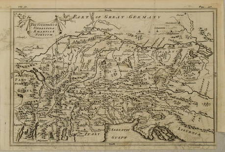
Sold20201750 c. Map of Eastern Alps Region in Ancient Times --Title: 1750 c. Map of Eastern Alps Region in Ancient Times -- The Countries of Vindelicia, Rhaethia & Noricum Cartographer: G Sale et al Year/Place: 1750 c., London Size: 7.8 X 11.8 in. Additional InfSee Sold Price
Sold2023Sale & Psalmanazar C1750 Map. Pannonia Moesia Davia and Illyricum Turkey GreeceCopper Plate Published 1747-68, London for "An Universal history, from the earliest account of time..." by George Sale, George Psalmanazar et al. Paper Size: 12.5 x 8 inch (32 x 20cm) Good ConditionSee Sold Price
Sold2022Cellarius & Patrick 1816 Map. Danube, Balkans"Pannonia Moesia, Illyricum & Thracia" Copper Engraved Map Published 1816, London for "Geographia Antiqua" by Samuel Patrick. Maps based on those by Andreas Cellarius. Folds as issued. Paper Size: 10See Sold Price
Sold2019Balkans.- Sanson (Nicolas) and Pierre Mariette.Balkans.- Sanson (Nicolas) and Pierre Mariette. Illyricum Orientis in quo Partes II Moesia et Thracia ..., historical map of the area west of the Black Sea, based on the cartography of Nicolas SansonSee Sold Price
Sold202117th c. Antique H/C Map of Ottoman / Turkish EmpireMap - Accuratissima et maxima totius Turcici Imperii tabula cum omnibus suis regionibus novissima delineatio | Title: Accuratissima et maxima totius Turcici Imperii tabula cum omnibus suis regionibusSee Sold Price
Sold2022NOVISSIMA ET ACCURATISSIMA TOTIUS AMERICAE FRAMED MAPNOVISSIMA ET ACCURATISSIMA TOTIUS AMERICAE FRAMED MAP Novissima et Accuratissima Totius Americae Descriptio map, circa 19th century, by Nicholas Visscher. Double-page map of North and South AmeriSee Sold Price
Sold2019Tabula Geographica Mexicae et Floridae, map of MexicoTabula Geographica Mexicae et Floridae, map of Mexico and Florida, hand colored copper engraving, "Carte du Mexique et de la Floride des Terres Angloises et des Isles Antilles", 1722 Jean Covens &See Sold Price
Sold2021Antique Framed Map. Virginia Marylandia et Carolina. JoAntique Framed Map. Virginia Marylandia et Carolina. Johannes Baptisa Homann-- Dimensions: Image Size: H: 21 inches: W: 24.5 inches -- FRAME SIZE: Frame Height 25 inches - Frame Width 28.5 inches ---See Sold Price
Sold2024VIRGINIA ET FLORIDA MAPG. Mercator/I. Hondius - 1857; normal wear; matted and framed; 15" x 20", G-G+See Sold Price
2017Homann: Antique Map of Malta & Valetta View, 1720Map: Insularum Maltae et Gozae Cartographer: J. B. Homann Place & Date: Nurnberg / 1720 Size: 20" x 18" Condition: old color on islands and inset plan, cartouche and inset view in b&w; light overall aSee Sold Price
Sold2020Grp: 7 Maps of Sicily and Sardinia ItalyGroup of seven maps of Sicily and Sardinia, Italy. Early 18th century Johann Homann (1664-1724) map "Regnorum Sicilia et Sardinia;" 18th century Homann Heirs map of Sicily "Regni & Insulae Siciliae TaSee Sold Price
Sold2018Homann: Maltese IslandsMap: Insularum Maltae et Gozae Cartographer: J. B. Homann Place/Date: Nurnberg / 1720 Size: 20" x 18" Condition: wash color; minor stains mostly in margins A beautifully colored and preserved exemplarSee Sold Price
Sold2017Sanson: Antique Map of the Ancient World, 1679Map: Orbis Vetus, et Orbis Veteris Utraque Continens, Terrarumque Tractus Arcticus et Antarctibus Cartographer: Nicholas Sanson Place & Date: Paris / 1679 Size: 21 1/4" x 15" Condition: outline color;See Sold Price
Sold2019Two Johann Baptist Homann (1661-1774) Maps, "VirginiaTwo Johann Baptist Homann (1661-1774) Maps, "Virginia Marylandia et Carolina in America Septatrionalis," c. 1720, hand colored, H.- 23 in., W.- 19 in. (2 Pcs.)See Sold Price
Sold20231720 Handcolored Homann Map TOTIUS AMERICAE SEPTENTRIONALIS ET MERIDIONALIS NOVISSIMA REPRAESENTATIOHistoric Maps Beautiful Hand-Colored Engraved Map by Johann Homann Titled: "TOTIUS AMERICAE SEPTENTRIONALIS ET MERIDIONALIS NOVISSIMA REPRAESENTATIO..." c. 1720 Hand-Colored Map titled, "TOTIUS AMERICSee Sold Price
Sold20241690 Danckerts Map of Africa -- Novissima et Perfectissima Africae DescriptioTitle: 1690 Danckerts Map of Africa -- Novissima et Perfectissima Africae Descriptio Cartographer: J Danckerts Year / Place: 1690 c., Amsterdam Map Dimension (in.): 19.2 X 22.7 in. This is an attractiSee Sold Price
Sold2023seutter Map, Novus Orbis sive AmericaSEUTTER, Georg Matthaus (1678-1757). Novus Orbis sive America Meridionalis et Septentrionalis... Engraved map with original hand color. Nuremberg, c. 1740. 19 5/8" x 22 3/4" sheet. This striking map oSee Sold Price
2019Carte de la Louisiane et pays voisins'. MississippiTITLE/CONTENT OF MAP: 'Carte de la Louisiane et Pays Voisins [Map of Louisiana and neighbouring country]' DATE PRINTED: 1757 IMAGE SIZE: Approx 23.0 x 31.5cm, 9 x 12.5 inches (Large); Please note thatSee Sold Price
Sold2023Carte de la Louisiane et pays voisins'. Mississippi basin. BELLIN 1757 mapCAPTION PRINTED BELOW PICTURE: Carte de la Louisiane et Pays Voisins [Map of Louisiana and neighbouring country] DATE PRINTED: 1757 IMAGE SIZE: Approx 23.0 x 31.5cm, 9 x 12.5 inches (Large); Please noSee Sold Price
Sold2024Framed Map AssortmentFramed Map Assortment (8) items with (3) maps by Willem Blaeu (Dutch, 1571-1638) including c.1660 'Tirolensis', 'Gastinois et Hurepois' and 'Hannoniae et Namurci', (2) maps by Robert de Vaugondy (FrenSee Sold Price
Sold202018th Century English School. "Sveciae, Norvegiae et18th Century English School. "Sveciae, Norvegiae et Daniae", a Map of Norway, Sweden and Denmark, 18.5" x 21.5".See Sold Price
1 day LeftJasper521770 French engraving map of Bonne,Rigobert Arabie. Mer Rouge et Golfe PersiqueUS$60
Featured2 days LeftJasper521775-1780 Virgin Islands, other Caribbean islands. By Bonne & Raynal.US$70
Jun 25Freeman's | Hindman[Maps & Atlases] Seutter, Matth(ias).: Novus Orbis sive America...US$300(1 bid)
5 days LeftTrillium Antique Prints & Rare BooksPrevost - Volume 16 with 31 Maps & Engravings (Including Map or Australia)US$210(2 bids)
2 days LeftJasper521758 MAP PARTIE DE LA MER GLACIALE contenants La Nouvelle Zemble RUSSIA antiqueUS$55


![Carte de la Louisiane et pays voisins'. Mississippi: TITLE/CONTENT OF MAP: 'Carte de la Louisiane et Pays Voisins [Map of Louisiana and neighbouring country]' DATE PRINTED: 1757 IMAGE SIZE: Approx 23.0 x 31.5cm, 9 x 12.5 inches (Large); Please note that](https://p1.liveauctioneers.com/5584/148431/74999206_1_x.jpg?height=310&quality=70&version=1566949447)
![Carte de la Louisiane et pays voisins'. Mississippi basin. BELLIN 1757 map: CAPTION PRINTED BELOW PICTURE: Carte de la Louisiane et Pays Voisins [Map of Louisiana and neighbouring country] DATE PRINTED: 1757 IMAGE SIZE: Approx 23.0 x 31.5cm, 9 x 12.5 inches (Large); Please no](https://p1.liveauctioneers.com/5584/309982/165835442_1_x.jpg?height=310&quality=70&version=1700599538)


![[Maps & Atlases] Seutter, Matth(ias).: Novus Orbis sive America... (1 of 2)](https://p1.liveauctioneers.com/65/332523/179335174_1_x.jpg?height=282&quality=70&version=1717709447)


