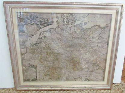
Sold2024L'Europa. Europe. DE ROSSI 1677 old antique vintage map plan chartTITLE/CONTENT OF MAP: L'Europa [Europe] DATE PRINTED: 1677 IMAGE SIZE: Approx 44.0 x 56.5cm, 17.25 x 22.25 inches (Large) TYPE: Antique 17th century folio atlas map CONDITION: Good; suitable for framiSee Sold Price
Sold2017Homann: Antique Map of SouthEast Europe, 1753Title/Content of Map: 1753 Homann Map os the Danube and SouthEast Europe -- Fluviorum in Europa principis Danubii cum adiacentibus Regnis nec non totius Graeciae et Archipelagi Novissima Tabula Date PSee Sold Price
Sold2018Blaeu Map of Europe -- Europa Recens DescriptaTitle/Content of Map: Blaeu Map of Europe -- Europa Recens Descripta Date: 1635, Amsterdam Cartographer: W Blaeau Size: 16.1 X 21.9 in. This is a grand, large, classic map of Europe, produced at the gSee Sold Price
Sold20231743 Homann Map of Europe -- Europa Secundum Legitimas Projectionis Stereographicae Regulas et JuxtaTitle: 1743 Homann Map of Europe -- Europa Secundum Legitimas Projectionis Stereographicae Regulas et Juxta Recentissimas Observationes Aeque ac Relationes… Cartographer: J. Homann Year / Place: 174See Sold Price
Sold20211598 Munster / Petri Map of Europe -- Europa das einTitle: 1598 Munster / Petri Map of Europe -- Europa das ein Drittheil der Erden nach gelegenheit unserer zeit beschrieben Cartographer: Munster / Petri Year/Place: 1598 c., Basel Map Dimensions (in.):See Sold Price
Sold2021Antique Framed Map of Europe, Europa Guilielmo BlaeuwAntique Color Map of Europe, Dutch Cartography. "Europa Recens Descripta" by Guilielmo Blaeuw, a cartographer for the Dutch East India Company. Lots of colorful detail of different nationalitiSee Sold Price
Sold2017Homann: Map of Europe, 1743Map: 1743 Homann Map of Europe -- Europa Secundum Legitimas Projectionis Stereographicae Regulas et Juxta Recentissimas Observationes Aeque ac Relationes… Cartographer: J. Homann Year / Place: 1743See Sold Price
Sold2021European School Chart / Map - Europa von 1918-1945European School Chart / Map - Europa von 1918-1945 - 55 in tall x 90 when openSee Sold Price
Sold20182 Maps: L’Italia + Italia Antiqua.[De Rossi/Sanson/Italy] 2 Maps. ++ Nicholas Sanson. Italia Antiqua cum Itineribus antiquis. Cum Insulis Sicilia Sardinia & Corsica. Rome: Jo. Jacob. De Rubeis. [C. 1690s.] At lower left: “Joannes L�See Sold Price
Sold2020[SEUTTER, M] 52 Maps of Europe sold togetherSEUTTER,M. 52 Maps of Europe sold together. ca. 1700. Includes. Europa ** Flandria ** Hanoniae ** Belgii **Luxemburg ** Dauphine Five Delpinatus ** Parmensis Et Placentinus ** Transylvaniae ** DucatusSee Sold Price
Sold2019Delamarche, Felix 1829 Lot of 3 Maps. Europe & Germany"L'Europe a l'Epoque du demembrement de l'Empire de Charlemagne" "L'Europe avan l'Invasion des Barbares" and "Germania Antiqua et regiones Danubium" Copper Engraved Maps Published 1829, Paris for "AtlSee Sold Price
Sold2023Eastern Europe sea chart Ports Lighthouses mail route Black Sea Baltic 1918 mapTITLE/CONTENT OF MAP: 'Eastern European Ports and Waterways' DATE PRINTED: 1918 IMAGE SIZE: Approx 49.0 x 34.0cm, 19.25 x 13.5 inches (Large) TYPE: Antique colour maritime map chart; Scale 1:20,000,00See Sold Price
Sold2020Philipp Cluver "Sicilia Antiqua" 1619Philipp Cluver (1580-1622), "Sicilia Antiqua; cum minoribus insulis, ei adjacentibus. Item, Sardinia et Corsica," 1619. A fine volume on historical Sicily with lovely maps. SKU: 02087See Sold Price
Sold2021Antique Map ETHNOGRAPHISCHE KARTE VON EUROPA, J. MeyerAntique Map ETHNOGRAPHISCHE KARTE VON EUROPA (German)(Translated: Ethnographic Map of Europe), Joseph Meyer (1796-1856) | Map shows the various races/peoples as they are spread throughout Europe. ThisSee Sold Price
Sold20231769 ANTIQUE MAP of EUROPE framed EUROPEAN POSTAL ROADS & STATIONS1769 ANTIQUE MAP: MAPPA GEOGRAPHICA EXHIBENS POSTAS omnes tam vehiculares quam verdarias Totius Germaniae cum earum accurata distantia Diligentissime propriis sumptibus excudit. Aug. Vindelicor. : TobSee Sold Price
Sold2017Map of Europe, 1879 by Justus Perthes, Gotha, GermanyEuropa In the scale of 1.15.000.000. Published. 1879. Gotha. Germany By A. Petermann. Justus Perthes, Adolf Stieler. Handatlas uber alle Theile der Erde und uber das Weltgebaude. Adolf Stieler, GothaSee Sold Price
Sold2018Menke: Antique Map of Europe at time of OdovacarsTitle/Content of Map: Europa Zur Zeit Odovacars (476-493.) Date Printed: 1874 Cartographer: MENKE, TH. Publisher: JUSTUS PERTHES 1874 GOTHA Size: Quarto – 12.80 H x 15.75 W Inches "Von Th. Menke..."See Sold Price
Sold2023Map of Europe 1619 – 1672 with towns and costumesDescription: Map of Europe 1619 – 1672 with towns and costumes / EUROPA RECENS DEFERIPTA.Measurement approximate:Material: PaperSee Sold Price
Sold2017De Wit Portolan Sea Chart of EuropeTotius Europae Victoria... Frederic De Wit (1630-1706). Engraved map with original hand color. Amsterdam, 1675. 20 x 35 1/2 inches sheet, 27 1/2 x 43 inches framed. “The most striking and decorativeSee Sold Price
Sold2023Early 19th century "Europe" by John Thomson 1817 old antique map plan chartTITLE/CONTENT OF MAP: 'Europe' DATE PRINTED: Published in 1817 IMAGE SIZE: Approx 49.0 x 56.5cm, 19.25 x 22.25 inches (Large); Please note that this is a folding map. TYPE: Antique early 19th centurySee Sold Price
Sold20231740 New Map or Chart Western Atlantic OceanFolding map being "A New Map or Chart of the Western or Atlantic Ocean with part of Europe Africa and America" Shewing the Course of the Galleons, Flota and C to the West Indies" piublished in 1740 anSee Sold Price
Sold20231740 New Map or Chart Western Atlantic OceanFolding map being "A New Map or Chart of the Western or Atlantic Ocean with part of Europe Africa and America" Shewing the Course of the Galleons, Flota and C to the West Indies" published in 1740 andSee Sold Price
Sold2023L'Europe. Europe. BONNE 1780 old antique vintage map plan chartTITLE/CONTENT OF MAP: 'L'Europe' A map of Europe DATE PRINTED: 1780 IMAGE SIZE: Approx 23.0 x 34.0cm, 9 x 13.5 inches (Large); Please note that this is a folding map. TYPE: Antique copperplate engraveSee Sold Price
Sold2023Martin, Benjamin 1772 Antique Map. Atlantic Ocean with Europe Africa America"A New Geographical Map or Chart of the Atlantic Ocean with the Continents of Europe, Africa & America &c on the East & West Side of it" Copper Engraved Map Published 1772, London for "The Young GentlSee Sold Price
May 16Potter & Potter AuctionsGEESINK, Joop (1913 – 1984). Europa. 1957. Netherlands: KLM...US$100
4 days LeftAdam's AuctioneersH.C CAREY AND I.LEA (publishers) A Complete Historical, Chronological and Geographical AMERICAN€1,500
May 21Hess Fine Auctions1885 A Popular History Of The United States JC Ridpath Gilt Green Leather Book IllustratedUS$10
May 12Schilb Antiquarian Rare Books1869 ATLAS 42 MAPS America Africa Australia GERMANY Switzerland Sydow RAREUS$130(3 bids)
May 09Hunt and Peck Estate Services, Inc.Abraham Ortelius Map Middle East "Turcici Imperii Descriptio"US$240(1 bid)
May 12Schilb Antiquarian Rare Books1881 Westchester County New York Yonkers Illustrated MAPS 2v SET Bolton HistoryUS$16(2 bids)
May 09Hunt and Peck Estate Services, Inc.Abraham Ortelius Map Middle East "Turcici Imperii Descriptio"US$140
May 09Hunt and Peck Estate Services, Inc.1776 William Burke 1st Ed 2 Volumes "An Account of the European Settlements in America"US$100


![L'Europa. Europe. DE ROSSI 1677 old antique vintage map plan chart: TITLE/CONTENT OF MAP: L'Europa [Europe] DATE PRINTED: 1677 IMAGE SIZE: Approx 44.0 x 56.5cm, 17.25 x 22.25 inches (Large) TYPE: Antique 17th century folio atlas map CONDITION: Good; suitable for frami](https://p1.liveauctioneers.com/5584/322790/173578184_1_x.jpg?height=310&quality=70&version=1710881198)


![2 Maps: L’Italia + Italia Antiqua.: [De Rossi/Sanson/Italy] 2 Maps. ++ Nicholas Sanson. Italia Antiqua cum Itineribus antiquis. Cum Insulis Sicilia Sardinia & Corsica. Rome: Jo. Jacob. De Rubeis. [C. 1690s.] At lower left: “Joannes L�](https://p1.liveauctioneers.com/179/117971/60557721_1_x.jpg?height=310&quality=70&version=1520636872)
![[SEUTTER, M] 52 Maps of Europe sold together: SEUTTER,M. 52 Maps of Europe sold together. ca. 1700. Includes. Europa ** Flandria ** Hanoniae ** Belgii **Luxemburg ** Dauphine Five Delpinatus ** Parmensis Et Placentinus ** Transylvaniae ** Ducatus](https://p1.liveauctioneers.com/1124/187577/94368891_1_x.jpg?height=310&quality=70&version=1607095126)