Sold2022MAPS IN BOOK, Atlases, CareyCarey's Famous 1814 General Atlas. Atlases. Mathew Carey, Carey's General Atlas, Improved and Enlarged: Being a Collection of Maps of the World and Quarters, Their Principal Empires, Kingdoms, &c., 18See Sold Price
Sold2024MAPS IN BOOKS, Atlases, Buy de MornasContains 135 Double-Page Maps in Contemporary Color. Atlases. Claude Buy de Mornas, [4 Volumes] Atlas Methodique et Elementaire de Geographie et d'Histoire, 1761-62 (published). Hand Color. A large anSee Sold Price
Sold2022Road Atlases, Maps, Books With Mineral AreasIncluded are maps and books of geology and mineral resources in North Carolina, AAA road maps of Colorado and Wyoming, two road atlases for Baltimore County and New Hampshire. Some areas are denoted aSee Sold Price
Sold20221833 Jos. Perkins A New General Atlas Map Book1833, written and engraved by Jos. Perkins, publisher - Anthony FinleySee Sold Price
Sold20181911 Philadelphia 24 34 44 Wards Atlas Map BookFirst few pages have wear, tear , and a couple are loose.See Sold Price
Sold2021Atq Map & Atlas Books, 1899 Spoffords & More - 1899Atq Map & Atlas Books, 1899 Spoffords & More - 1899 Maps Spofford's Cabinet Encyclopedia, 1906 Hammonds Pictorial Atlas of World w/ 1956 Hammond Double Day AtlasSee Sold Price
Sold20181928 Philadelphia 26th 36th 48th Wards Atlas Map BookApprox. 22" x 18 1/2" and 1 1/4" thickSee Sold Price
Sold2022[CATALOGUES] A large group of early auction and dealer catalogues relating to rare books, maps &[CATALOGUES] A large group of early auction and dealer catalogues relating to rare books, maps & atlases, and related collections, 1950s-70s. A fine large collection of auction catalogues from Parke BSee Sold Price
Sold2018Pierre Tardieu Atlas, Twenty-Six Maps 1799-1800Pierre Tardieu Atlas with all maps dated 1799 or 1800. Contains twenty-six engraved maps on individual pages with blank backs. Sheet sizes are 10 13/16" x 16" (27.5cm x 41.5cm). Includes Egypt, FrenchSee Sold Price
Sold2017VARIOUS ATLAS AND MAP BOOKSVARIOUS ATLAS AND MAP BOOKS- RAND McNALLY FAMILY WORLD ATLAS- SIXTH PRINTING 1987- HARD COVER- THE MAP BOOK EDITED BY PETER BARBER- FIRST PUBLISHED IN THE U.S. IN 2005- HARD COVER- THE MAP CATALOG- 3RSee Sold Price
Sold2023Charlene Mathews (20 th / 21 st Century) CaliforniaATLAS OF BOOK MAPS, 2011, artist handmade book, with 6 illustrations of enlarged black & white photos backed with Irish Linen with mylar overlay sheets: includes Key to “The Killer Inside Me”See Sold Price
Sold202019th Century Colored Map of NH & VT19TH CENTURY ATLAS BOOK PLATE MAP OF NEW HAMPSHIRE AND VERMONT- JOHNSON'S NH AND VT BY JOHNSON AND WARD- 26 1/2" X 17 3/4"- TONING, FOXING, CREASES, SMALL LOSSES TO EDGES AND IMPERFECTIONSSee Sold Price
Sold20182 Boxes of Books on Maps & Atlases2 Boxes of Books on Maps & Atlases-- Dimensions: ---See Sold Price
Sold20211872 Morgan County, Illinois Atlas & History Book1872 Morgan County, Illinois Atlas & History Book. (1) Atlas Map of Morgan County Illinois, by Townships, 1872. Measures 17 3/4" x 14 3/4". (1) A History of Lawrence, Kansas: From the First SettlementSee Sold Price
Sold20211830 "A New Atlas World" Educational School Map Book1830 "A New Atlas World"Antique Educational School Maps. This is a wonderful antique atlas for early education, geography classes. It has a layout of the world and the breakdown of each continent. BecSee Sold Price
Sold2017Tardieu Map of Western AmericanCarte du Mexique ou de la Nouvelle Espagne. Ambroise Tardieu. From Robertson's Atlas. Engraved map with map with handcolor. Paris, 1821. 12 x 15 1/2 inches sheet. This very attractive French map of thSee Sold Price
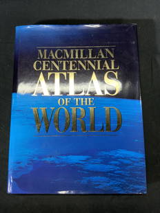
Sold2022Macmillan Centennial Atlas of the World BookMacmillan Centennial Atlas of the World. Published by Macmillan, 1997. Wear to cover and jacket consistent with exposure. Measures approx. 12 x 15.5 inches. Atlas, map, topography, photo book, referenSee Sold Price
Sold2022ANTIQUE WORLD MAPS AND AMERICAN HISTORY BOOKSA lot of eight antique and vintage historical books and maps. Arbuckles Illustrated Atlas of Fifty Principal Nations of the World, 1890. Lois Marie Hunter, The Shinnecock Indians, 1960. Replogle WorldSee Sold Price
Sold2023Book, Atlas of Tuscarawas County, Ohio, 1875"Combination Atlas Map of Tuscarawas County, Ohio" By L.H. Everts & Co. (Philadelphia: 1875), Folio, hardcover. Boards worm, separated, and and wear along some page edges, otherwise complete and in goSee Sold Price
Sold2023Book, "Atlas of Trumbull County, Ohio" 1874"Combination Atlas Map of Trumbull County, Ohio" By L.H. Everts (Chicago: 1874), Folio, hardcover. Spine loose and boards worn, otherwise contents complete and in good condition.See Sold Price
Sold20211844 Mitchell's Ancient Atlas Map Book,Hand ColoredAntique Geography Book, Mitchell's Ancient Atlas 1844. A school instructional book "Containing Maps Illustrating Geography of the Ancient World". Published in Philadelphia by E.H. Butter & Co. DimensSee Sold Price
Sold2017Lot of 3 Vintage Reference BooksThree vintage references books; Merriam-Webster Pocket Book collectors edition; Leather bound , Atlas of Ancient and Classical Geography including fold out maps, book is separated into two pieces; LeaSee Sold Price
Sold2023MAPS IN BOOK, France, Le RougeIncludes Plans of New Orleans and Quebec. France, Atlases. Le Rouge, Recueil des Fortifications Forts et Ports de Mer de France Lave au Pinceau, 1760 (circa). Black & White. This book contains 89 platSee Sold Price
Sold2023Korean Atlas Book or Ch'onha Chido.(KOREAN ATLAS.) Ch'onha Chido [Atlas of all under Heaven]. Includes (9) double page maps, and (2) double pages of inscriptions (possibly a key to the maps??). Front and back covers with inscriptions.See Sold Price
2 days LeftTrillium Antique Prints & Rare BooksBraun & Hogenberg, pub. 1575 - View of Ostia, ItalyUS$140(2 bids)
2 days LeftTrillium Antique Prints & Rare BooksBraun & Hogenberg, pub. 1575 - Views in the Middle East: Aden, Mombasa, Kilwa, & SofalaUS$100(1 bid)
2 days LeftTrillium Antique Prints & Rare BooksBraun & Hogenberg, pub. 1575 - View of Delft, NetherlandsUS$100
2 days LeftTrillium Antique Prints & Rare BooksBraun & Hogenberg, pub. 1575 - View of Alexandria, EgyptUS$100(1 bid)
2 days LeftTrillium Antique Prints & Rare BooksBraun & Hogenberg, pub. 1575 - View of Lyon, FranceUS$100
2 days LeftTrillium Antique Prints & Rare BooksBraun & Hogenberg, pub. 1575 - View of Chester, EnglandUS$100
2 days LeftTrillium Antique Prints & Rare BooksPrevost - Chart of the Islands of Java, Sumatra, Borneo, &c.US$50
2 days LeftTrillium Antique Prints & Rare BooksPrevost - Pair of Engravings of Santo Domingo or HispaniolaUS$50
2 days LeftTrillium Antique Prints & Rare BooksPrevost - 3 Natural History Engravings of Avocado, Passion Flower, Aloe, Flying Squirrel, & LizardUS$50
5 days LeftJasper52Maine... for the Maine State Year Book G.M. Donham, Publisher. Portland Maine.US$40
2 days LeftRapid Estate Liquidators and Auction Gallery1899 20 History Of The British Army Books & MapsUS$1,500


![MAPS IN BOOKS, Atlases, Buy de Mornas: Contains 135 Double-Page Maps in Contemporary Color. Atlases. Claude Buy de Mornas, [4 Volumes] Atlas Methodique et Elementaire de Geographie et d'Histoire, 1761-62 (published). Hand Color. A large an](https://p1.liveauctioneers.com/6576/320593/172252664_1_x.jpg?height=310&quality=70&version=1708729193)


![[CATALOGUES] A large group of early auction and dealer catalogues relating to rare books, maps &: [CATALOGUES] A large group of early auction and dealer catalogues relating to rare books, maps & atlases, and related collections, 1950s-70s. A fine large collection of auction catalogues from Parke B](https://p1.liveauctioneers.com/292/250642/130213445_1_x.jpg?height=310&quality=70&version=1654271664)


![Korean Atlas Book or Ch'onha Chido.: (KOREAN ATLAS.) Ch'onha Chido [Atlas of all under Heaven]. Includes (9) double page maps, and (2) double pages of inscriptions (possibly a key to the maps??). Front and back covers with inscriptions.](https://p1.liveauctioneers.com/483/307467/164324833_1_x.jpg?height=310&quality=70&version=1698431865)


