Sold2023Jodocus Hondius and Gerardus Mercator: India OrientalisJodocus Hondius and Gerardus Mercator: India Orientalis Engraved map with hand-coloring, c. 1606, with label from I.D.L. Antiques, Hong Kong. 13 3/4 x 18 3/4 in. (sight), 23 x 28 in. (frame). PropertySee Sold Price
Sold2024Matthaus Merian 1627 Antique Map Engraving "Virginia" from Theodore de Bry's "Grand Voyages" #1Antique 1627 map of Virginia by Matthaus Merian after John Smith's 1612 map, from Theodore de Bry's "Grand Voyages". Please see "The Philidelphia Print Shop" sheet shown in final photo. Good conditionSee Sold Price
Sold2016MAP MAKER MATTHAUS MERIAN"Tabula Russiae ex autographo, quod delineandum curavit Foedor filius Tzaris Boris . . . Map Maker: Matthaus Merian.", Frankfurt, 1640" Printed and hand colored on paper Dimensions: H12" x W 15" CondiSee Sold Price
Sold2024Matthaus Merian 1627 Antique Hand Colored Map "Virginia" from Theodore de Bry's "Grand Voyages" #2Antique 1627 hand-colored map of Virginia by Matthaus Merian after John Smith's 1612 map, from Theodore de Bry's "Grand Voyages". Good condition overall, with age-appropriate wear, repairs (see photosSee Sold Price
Sold2020Grp: Maps of AsiaGroup of maps of Asia. Includes Matthaus Merian (1593-1650), "Xuntien alias Quinzay," from the "Archontologia Cosmica," Frankfurt, ca. 1690. "Carte de la Baye de Chin-Chew ou Chang-Chew Avec les IslesSee Sold Price
Sold2016Seutter map of Southeast AsiaHeading: Author: Seutter, Matthew Title: India Orientalis cum Adjacentibus Insulis Nova Delineatione ob oculos posita Place Published: Augsburg Publisher: Date Published: [c.1745] DescSee Sold Price
Sold2019Seutter map of Southeast AsiaHeading: Author: Seutter, Matthew Title: India Orientalis cum Adjacentibus Insulis Nova Delineatione ob oculos posita Place Published: Augsburg Publisher: Date Published: [c.1745] DescSee Sold Price
Sold2022After Matthaus Merian German Castle Color EtchingItem/Description: Antique colored etching features a three-dimensional map view of "Maintz und Castel vor dem bombardement 1793" (Maintz and Castle before the 1793 bombing) by Matthaus Merian, The EldSee Sold Price
Sold2017Merian: Map of Denmark, Dania Regnum, 1638Title: Dania Regnum Map maker: Matthäus Merian, Neuwe Archontologica Cosmica Place and Year: Frankfurt, 1638 Dimensions: 35.5 x 28 cm (14 x 11 in) Technique: Copperplate engraving Coloring: UncoloredSee Sold Price
Sold20181664 Merian small map of Bohemia (Czech Republic)Title: Bohemia Map maker: Matthäus Merian, Theatrum Europaeum Place and Year: Frankfurt, 1664 Dimensions: 15 x 18 cm (5.9 x 7 in) Technique: Copperplate engraving Coloring: Uncolored Condition RatingSee Sold Price
Sold2024[Maps] Martin Zeiler, Itinerarium Italiae, 1640[Maps] Martin Zeiler, Itinerarium Italiae, 1640, Martini Zeilleri. Itinerarium Italiae Nov-Antiquae: oder, Raiss-Beschreibung durch Italien, Matthaus Merian, Frankfurt, 40 plates, most double-page, inSee Sold Price
Sold2024Abraham Ortelius Indiae Orientalis 1580 MapAbraham Ortelius (Belgian, 1527-1598). Indiae Orientalis, Insularumque Adiacientium Typus, circa 1580. Hand colored engraved map of India, China, southeast Asia. Text page, India, in Latin on verso. 1See Sold Price
Sold2017Hondius Map of IndiaIndia quae Orientalis dicitur et Insulae Adiacentes. Henricus Hondius (1597-1651). Copperplate engraving. Amsterdam, c. 1636. 17 x 21 3/4 inches sheet. An important Dutch map of South East Asia, notewSee Sold Price
Sold201617th century map of Russia by MerianHeading: Author: Merian, Matthaus, the elder Title: Tabula Russiae... alias dicta Moscovia Place Published: Frankfurt Publisher: Date Published: [c.1645] Description: Copper-engSee Sold Price
Sold2019Two Maps by Willem Janszoon Blaeu (1571-1638),Two Maps by Willem Janszoon Blaeu (1571-1638), "Virginiae partis australis et Florida partis orientalis," 1640, hand colored, H. - 15 in., W. - 20 in.; together with India Quae Orientalis Diktur et InSee Sold Price
Sold2018South East Asia.- Ortelius (Abraham) Indiae OrientalisSouth East Asia.- Ortelius (Abraham) Indiae Orientalis Insularumque Adiacientium Typus, map of southern Asia from India across to Java and New Guinea, and including China and Japan to the north, withSee Sold Price
Sold2019FOUR VIEWS OF STETTIN AND POMERANIA German, Dutch i.a.,FOUR VIEWS OF STETTIN AND POMERANIA German, Dutch i.a., i.a. Matthäus Merian, Johannes Janssonius, Matthäus Seutter, 17th/18th century and later Engraving, partly coloured, on different papeSee Sold Price
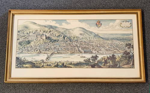
Sold20201620 Hand-colored Copperplate Engraved Haidelberga MapHeidelberg-Panorama von Matthaeus Merian 1620 - Description''': historic views of Heidelberg, Germany Birds Eye View Heidelberg 1620 Rare Copperplate Engraving by Matthäus Merian MAP - MatthäusSee Sold Price
Sold2023Mercator, America Sive India Nova Map, 17th century"America Sive India Nova..." hand colored. Dimensions:Sight is 15" x 18 1/2", the frame 21" x 24 1/2". Provenance:From a Philadelphia Collection.See Sold Price
Sold2017Antique Map of India into Southeast Asia, 1541Map: India into Southeast Asia Date Printed: 1541 Cartographer: Waldseemuller & Friers Material/Medium: Paper Size: 21" X 14 1/4" Condition: Excellent Second oldest Map of India into Malay peninsula.See Sold Price
Sold2019Willem Janszoon Blaeu (1571-1638), "Virginiae partisWillem Janszoon Blaeu (1571-1638), "Virginiae partis australis et Florida partis orientalis," 1640, hand colored, H. - 15 in., W. - 20 in.India Quae Orientalis Diktur et Insulae, 1640, H. - 22 in., W.See Sold Price
Sold2018India.- Joseph (Charles) Map of the Grand Trunk RoadIndia.- Joseph (Charles) Map of the Grand Trunk Road from the Karamnassa to the Sutledge, Part Second, from Agra to Ferozepoor, large folding road map of one of the oldest and longest trade routes linSee Sold Price
Sold2017Dutch East India Co.: Antique Map of the World, 1670Map: Mappe-Monde pour connoitre les progres & les conquestes les plus Remarquables des Provinces-Unies, Ainsy que celles des Compagnies d'Orient et d'Occident Cartographer: Dutch East India Company PlSee Sold Price
Sold2018Ortelius Antique Map: Indiae Orientalis Insularum QueTitle/Content of Map: Indiae Orientalis Insularum Que Adiacientium Typus Date Printed: 1588 Cartographer: Abraham Ortelius Material/Medium: No color, strong impression. Spanish text on verso. From theSee Sold Price
Jun 08Leon GalleryJodocus Hondius 1606 (Jodocus Hondius and Cornelis Claesz) - India Orientalis₱40,000
Jun 08Leon GalleryAbraham Ortelius (1527 - 1598) - Indiae Orientalis (Philippines/China/ India/ Southeast Asia)₱200,000
214 Lots AwayHermann Historica GmbH"The Drudenhaus" (jail for witches) of Bamberg", copperplate, 1627See Sold Price
Jun 12Dan Morphy AuctionsPLATE CXIII. MAP OF INDIAN TERRITORY SHOWING DISTRIBUTION OF WOODLAND” FROM THE TWENTY-FIRSTUS$100
Featured1 day LeftJasper52c1720 World showing Dutch East India Co possessions. CA as a island. By J.MalherbeUS$600
Jun 08Simpson Galleries, LLC.MATTHAUS SEUTTER (1678-1757) A MAP OF THE HOLY LAND AND TWELVE TRIBES, "Terra Sancta Vocatta QueUS$150
Jun 07Freeman's | HindmanBELLIN, Jacques-Nicolas. Carte Reduite de L'Ocean Oriental ou Mer Des Indies. Paris, 1757. SecondUS$150


![Seutter map of Southeast Asia: Heading: Author: Seutter, Matthew Title: India Orientalis cum Adjacentibus Insulis Nova Delineatione ob oculos posita Place Published: Augsburg Publisher: Date Published: [c.1745] Desc](https://p1.liveauctioneers.com/642/86438/44449722_1_x.jpg?height=310&quality=70&version=1458591928)
![Seutter map of Southeast Asia: Heading: Author: Seutter, Matthew Title: India Orientalis cum Adjacentibus Insulis Nova Delineatione ob oculos posita Place Published: Augsburg Publisher: Date Published: [c.1745] Desc](https://p1.liveauctioneers.com/642/151690/76551287_1_x.jpg?height=310&quality=70&version=1570486555)


![[Maps] Martin Zeiler, Itinerarium Italiae, 1640: [Maps] Martin Zeiler, Itinerarium Italiae, 1640, Martini Zeilleri. Itinerarium Italiae Nov-Antiquae: oder, Raiss-Beschreibung durch Italien, Matthaus Merian, Frankfurt, 40 plates, most double-page, in](https://p1.liveauctioneers.com/188/326797/176317459_1_x.jpg?height=310&quality=70&version=1713847031)


![17th century map of Russia by Merian: Heading: Author: Merian, Matthaus, the elder Title: Tabula Russiae... alias dicta Moscovia Place Published: Frankfurt Publisher: Date Published: [c.1645] Description: Copper-eng](https://p1.liveauctioneers.com/642/86438/44449706_1_x.jpg?height=310&quality=70&version=1458591928)