Sold20201684 Pas kaart Van de Caribes Tusschen I. Barbados en IThis is an authentic antique map of the Lesser Antilles by Johannes Van Keulen. The map was published in Amsterdam in the year 1684. This is an impressive hand colored example of Van Keulen’s nSee Sold Price
Sold20211613 America sive India Nova ad magnae GerardiBy: Michael MercatorDate: 1613 / DuisbergDimensions: 16 x 19.5 inches (40.7 x 49.5 cm)This is an authentic antique map of the Western Hemisphere by Michael Mercator. The map is based on Rumold MercatoSee Sold Price
Sold20211627 Carte de l'Amerique Corrigee, et Augmentee, dessusBy: Bertius/TavernierDate: 1627 (circa)Dimensions: 20 x 15.25 inches (50.75 x 38.5 cm)According to Burden, "This rare map is one of a set of the four known continents that Melchior Tavernier had engraSee Sold Price
Sold2020The Western Coast of Louisiana... Coast of New LeonA first state example of the earliest map to focus on the coast of Texas, recognized as the New Kingdom of Leon” This landmark map of the Texas coast presents the area as the Kingdom of Leon,” andSee Sold Price
Sold20211794 A New and General Map of the Middle DominionsBy: Lewis Evans published by Laurie & Whittle Date: 1794 (Published) London Dimensions: 18.75 x 25.6 inches (47.6 x 65.02 cm) This is a fine old color example of the Laurie & Whittle edition of LewisSee Sold Price
Sold20211661/1707 Corporum Coelestium MagnitudinesBy: Andreas Cellarius - pub. by Valk & SchenkDate: 1661 / 1708 (published) AmsterdamDimensions: 16 x 19.5 inches (40.5 x 45.5 cm)Beautiful celestial map by the famous cosmographer Andreas Cellarius, sSee Sold Price
Sold20211658 Nova et Accurata Iaponiae, Terrae Esonis, acBy: Johannes JanssonDate: 1658 (published) AmsterdamDimensions: 18 x 22 inches (45.7 x 55.9 cm)This is an authentic antique map of Japan and Korea, showing portions of China, Landt van Eso and CompagnSee Sold Price
Sold2020Asia IV Tab.This is an early and scarce map of present day Saudi Arabia, Qatar, United Arab Emirates, Yemen, and Oman. Only the first (1578) and second (1584) editions of the atlas were published during Gerard MeSee Sold Price
Sold20211584 Asia VI Tab.By: Mercator / PtolemyDate: 1584 (circa) Amsterdam.Dimensions: 19 x 13 inches (48.25 x 33 cm)This is an early and scarce map of present day Saudi Arabia, Qatar, United Arab Emirates, Yemen, and Oman.See Sold Price
Sold20211588 Africae Tabula NovaBy: Abraham OrteliusDate: 1588 (published) AntwerpDimensions: 14.5 x 18 inches (36.83 x 45.72 cm)This is an authentic antique map of Africa was published by Abraham Ortellius in 1588. It was taken froSee Sold Price
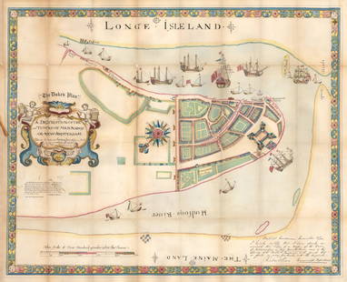
Sold20211664 / 1859 "The Duke's Plan" A Description ofBy: original cartographer unknown / Reissue by: David Thomas Valentine / Engraved by: George HaywardDate: original manuscript 1664 / Reissue 1859 (Published) New YorkDimensions: 21.75 x 27.25 inches (See Sold Price
Sold2020Kaarte van de Golf van Mexico en het Zuyd-America waarBy: Daniel de la FeuilleDate: 1747 (Published) AmsterdamDimensions: 19.5 x 22.5 inches (50 cm x 57 cm)This is an extremely rare and highly unusual map by the cartographer Daniel de la Feuille, and engSee Sold Price
Sold20211654 Mappa Aestivarum Insularum, alias BarmudasBy: Jan JanssonDate: 1654 (published) AmsterdamDimensions: 15.5 x 20.5 inches (39.4 x 52 cm)This is an authentic antique map of Bermuda by Jan Jansson. The map was published out of Amsterdam circa 165See Sold Price
Sold20191849 India Shewing The Post Roads And Dawk StationsThis remarkably detailed large format map of India and parts of bordering countries highlights the means of transportation in mid-19th century India of both people and goods in the vast region depicteSee Sold Price
Sold2021Insulae Americanae in Oceano Septentrionali cum TerrisInsulae Americanae in Oceano Septentrionali cum Terris adiacentubisA 1671 black and white Ogilby edition of the original drawn by Gerritsz 40 years earlier. Depicts the southeastern corner of North AmSee Sold Price
Sold20211716 Nova Anglia Septentrionali Americae implanataBy: Johann Baptiste HomannDate: 1719 (published) AmsterdamDimensions: 19 x 22.5 inches (48 x 57 cm)An intriguing map of the northeastern portion of the United States at a time when several European naSee Sold Price
Sold20211843 Geological Map of the Middle and Western StatesBy: James HallDate: 1843 (published)Dimensions: 23 x 32 inches (58.5 x 81 cm)This is a beautifully colored geological lithograph map by the iconic American geologist James Hall. The map covers most orSee Sold Price
Sold2020Lot of 6 Maps of Africa 1618-1813Guinea (under heading: Descriptio Gvineæ.) By Petrus Kerius Pieter van der Keere For atlas of Petrus Bertius (Pieter de Bert), Amsterdam, 1618 , page 652. 9 cm x 13 cm Watermarked paper. Small faSee Sold Price
Sold20201574 Bruxella.The earliest obtainable map of Brussels, Belgium. The plan shows an idealized almost circular view of the city with city walls nearly entirely ringed by a moat on one side and the River Senne on the oSee Sold Price
Sold20211825 Estats-Unis D'AmeriqueBy: Jean Alexandre BuchonDate: 1825 (published) ParisDimensions: 16.75 x 21 inches (42.5 x 53.5 cm)This is an authentic antique map of the United States with portions of Mexico and Canada, by Jean AleSee Sold Price
Sold20201666 Pas-Caart van Guinea en de Custen daer aen gelegenThis is an authentic antique map of the western coast of Africa. The map was published by Pieter Goos in his atlas De Zee-Atlas, Ofte Water-Weereld… out of Amsterdam. With an easterly orientatioSee Sold Price
Sold20201873 Geological Map of the United States Compiled byThis colorful map of the United States was compiled by Professors C.H. Hitchcock and W.P. Blake and is one of the most important early geological maps of the United States, one which would be copied bSee Sold Price
Sold20201574 Vienna & BudaPublished 1574, Cologne. By Braun & Hogenberg. Latin text on reverse. From atlas “ Civitates Orbis Terrarum”See Sold Price
Sold20201826 Map of the United States Drawn from the Most1826, New York. Published by Solomon SchoyerSee Sold Price
5 days LeftRich Penn AuctionsWorld's Fair Souvenir Glasses, 1964-1965 New York World's Fair set of 8 in orig box, each shows anUS$60(2 bids)
1 day LeftJasper52New York World's Fair - Noted Artist Leslie Ragan (1939) 27.5x39.5 US Travel PosterUS$700
11 hrs LeftRapid Estate Liquidators and Auction Gallery1964 New York Worlds Fair Mobil Host PackUS$45
3 days LeftPotter & Potter AuctionsPEAK, Bob. New York World’s Fair / 1964-1965. Offset lithog...US$200
3 days LeftPotter & Potter Auctions[NEW YORK CITY – PICTORIAL MAPS]. Group of 3 pictorial maps...US$200(1 bid)
2 days LeftRapid Estate Liquidators and Auction GalleryThe World Of Tomorrow 1939 Worlds Fair HardcoverUS$30
2024Rapid Estate Liquidators and Auction GalleryWorlds Fair Morris Gest's Little Miracle Town BookletSee Sold Price
Jun 07Freeman's | HindmanAn archive of ephemeral materials from the World Science Fiction Convention. Roughly 1939-1991.US$350
May 25Caff's Collectibles2023 Topps World Baseball Classic New Sealed Unopened Box 1 Autograph or RelicUS$75
May 26Caff's Collectibles2023 Topps World Baseball Classic New Sealed Unopened Box 1 Autograph or RelicUS$75
3 days LeftPotter & Potter AuctionsEKMAN, Stanley (1913 – 1998). Go by all Means / World’s Fai...US$80(1 bid)
2 days LeftRapid Estate Liquidators and Auction GalleryLot of 8 National Geographic Magazines From the 60s and 70sUS$25
Jun 08Potter & Potter AuctionsCLARK, Hyla M. The World’s Greatest Magic. New York: Tree C...US$100


![[NEW YORK CITY – PICTORIAL MAPS]. Group of 3 pictorial maps... (1 of 3)](https://p1.liveauctioneers.com/928/325952/175495562_1_x.jpg?height=282&quality=70&version=1712935174)


