Sold2017Cary: Map of the United States, 1811An original 1811 framed hand colored engraved map titled "A New Map of the United States of America from the Latest Authorities" created by John Cary for the 2nd edition of his New Universal Atlas oriSee Sold Price
Sold2023Framed Engraved Map of Eastern US by E. Jones 1805Featured in this lot is this original 1805 E. Jones engraved map showing the United States from Maine to Georgia (Florida is cut off) and west to the Mississippi. The map was engraved by E. Jones, andSee Sold Price
Sold201718thc Map: United States of America, Wilkes, 1797Framed antique map, United States of America, Published London 1797 by J. Wilkes. Engraved by Neele, 352 Strand, London. Hand colored, the map shows the United States in the Decade after the AmericanSee Sold Price
Sold2022Map of United States, JH Colton, ca 1849A framed map of the United States, Map of the United States of America, The British Provinces, Mexico, the West Indies and Central America with part of New Granada and Venezuela by JH Colton, ca 1849,See Sold Price
Sold2017UNITED STATES 1860 MAP, J.W. LOWRY, TERRITORIESFramed map of "The United States of North America (General Map)", c. 1860, "drawn and engraved by" J.W. Lowry (Joseph Wilson Lowry, British, 1803-1879), published by Blackie & Son, Glasgow, EdinburghSee Sold Price
Sold2017MAP OF THE UNITED STATES, C. 1861Framed map of the United States, 1861, showing 32 named states with western areas mostly in irregular shapes, penciled date of 1861, sight: 3.5/8"h, 5.75"w, overall: 10"h, 12'w, 1.5lbs Start Price: $8See Sold Price
Sold2021North AmericaTitle: North America Artist: SDUK Medium: Engraving Dimensions: 14 1/8 x 12 1/2 Description: 1834 map of the United States by the Society for the Diffusion of Useful Knowledge Reserve: $50.00 ShippingSee Sold Price
Sold2018Small Robert Morden antique hand coloured map ofSmall Robert Morden antique hand coloured map of Middlesex, together with a set of six framed maps of the United StatesSee Sold Price
Sold2022Set of Framed 19th C. Relief Maps (3)Printed in Chicago, 1893, set includes a framed relief map of the United States, a relief map of Europe, and a relief map of the world, 27" x 37 1/2" sight, 34" x 47 1/2" framed.See Sold Price
Sold20221910 United States MapOriginal 1910 map of The United States, hand-colored, multi-fold map from The Encyclopedia Britannica. Mounted on form board with vintage mat board. 13" X 17 1/2".See Sold Price
Sold20241825 Framed United States MapApprx 23 1/2" x 27 1/2". If shipping is needed, get a quote thru UPS Store 5528 before bidding.See Sold Price
Sold20232 Framed Maps of Canada & U.S.Group of two framed maps depicting Canada and the United States. One map depicting the East Coast of the United States as well as southeastern Canada. One map depicting Lake Superior and south-centralSee Sold Price
Sold2023Rare 19thc Census Map, U.S. Agricultural ProductionExtremely rare, original 1876 atlas map of the United States Agriculture Production - five agricultural maps (in inset form) of the production of wheat, hay, corn, cotton and tobacco. Each map distingSee Sold Price
Sold2018MAPS: (2) U.S. Regional 1846 Meyer's AtlasMAPS: (2) U.S. Regional 1846 Meyer's Atlas, Pair of United States regional maps. Framed, sizes given are area inside mat followed by overall framed size. Both from Meyer's Universal Atlas and marked SSee Sold Price
Sold2018Framed Antique U.S. MapsFramed Antique Maps of U.S. and Eastern United States. To 23" x 18".See Sold Price
Sold2021INDIAN TRIBES MAPS & INDIAN PORTRAIT ARTINDIAN TRIBES MAPS & INDIAN PORTRAIT ARTVintage framed paper map of Indian Tribes in the United States, printed by Dollar-wise Springprint Springfield, Ohio. Print of Native American mSee Sold Price
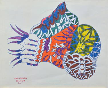
Sold2017Jimi Hendrix Original Framed Abstract PaintingAn original abstract painting by Jimi Hendrix. Measures approximately 6 3/4 x 7 3/4'', good condition. According to Hendrix's United States publicity agents, Jimi often carried notepads and art boardsSee Sold Price
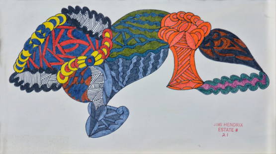
Sold2017Jimi Hendrix Original Framed Abstract PaintingAn abstract watercolor painting by Jimi Hendrix. Measures approximately 5 x 9 1/4'', good condition. According to Hendrix's United States publicity agents, Jimi often carried notepads and art boards wSee Sold Price
Sold2018PRES. THEODORE and EDITH ROOSEVELT - Original FramedBE073 - CUSTOM FRAMED: Amazing piece of US Political History. Rare signature clippings of our 26th President of the United States, Theodore Roosevelt (added, "Nov 20th 1903") and the 1st Lady Edith RoSee Sold Price
Sold2020Framed map of the state of New Jersey compiled from theFramed map of the state of New Jersey compiled from the most authentic information, compiled by Samuel Lewis. From Carey's General Atlas, 1814. The first atlas made in the United States to employ stanSee Sold Price
Sold20231819 LIZARS MAP UNITED STATES.W & D Lizars Edinburgh map of the United Sates of America 1819, image 15” x 17,5” framed under glass overall 23” x 25”See Sold Price
Sold2021CIVIL WAR-ERA JOHNSON'S MILITARY MAP UNITED STATESFramed engraving with color on paper, "Johnson's New Military Map of the United States, Showing the Forts, Military Posts & c., with Enlarged Plans of Southern Harbors from Authentic Data Obtained atSee Sold Price
Sold2021(3) MAPS: UNITED STATES, MARTHA'S VINEYARD, EUROPE(lot of 3) Framed maps, including: (1) Martha's Vineyard, U.S. Geological Survey, sight: 10.25"h, 14.25"w, overall: 12"h, 16"w, (1) Hungarian map of Europe, sight: 8.25"h, 10"w, overall: 13.25"h, 15"wSee Sold Price
3 days LeftEarly American History Auctions1800 Published, Lansdowne Portrait of George Washington Engraved by James Heath After Gilbert StuartUS$1,000
2 days LeftMynt AuctionsFrida Kahlo Self-Portrait on Borderline between Mexico & USA Custom Framed PrintUS$10