Sold2022Panoramic Map of Jerusalem Book - 1845Panoramic Map of Jerusalem and the Adjacent Towns and Villages, from a drawing by the Librarian of the Armenian Convent. Drawn from the original and engraved by Nathaniel Whittock. Bound in a book thaSee Sold Price
Sold2016Panoramic Map of Jerusalem - Leipzig, 1852Das Biblische Jerusalem aus der vogelschau, Adolf Eltzner. Published by J.J. Weber, Leipzig, 1852. Engraved panoramic map of Jerusalem, Folded. 41.5X58 cm. Good condition. Stains. Bound in hard cover.See Sold Price
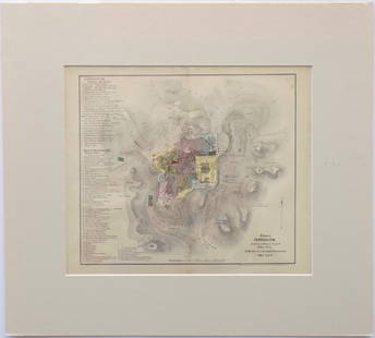
Sold2017Ierusalem - Panoramic Map View of Jerusalem, ProbablyIerusalem - Panoramic Map View of Jerusalem, Probably 18th Century. Following the map of Jacques Chereau (1688-1776) from the 18th century. Copperplate. Colored. 21x34cm.See Sold Price
Sold2021Panoramic Map of the Holy LandMap of Eretz Israel, its cities and its holy sites including Jerusalem, Hebron, Jaffa, Tiberias and Safed. Originally made by Rabbi Chaim Solomon Pinie from Safed, and first printed in the 19th centurSee Sold Price
Sold2022Halma Franciscus (Dutch, 1653-1722) - Jerusalem Panorama, Etching, 1717.Halma Franciscus Francois (Dutch, 1653-1722) - Jerusalem Panorama, Etching, 1717. Panoramic bird's-eye view of Jerusalem seen from the East. The map has two keys, one on the left (with leSee Sold Price
2017Merian: Antique Panoramic View of Jerusalem, 1640sMap: Ierusalem Cartographer: Merian Place & Date: Frankfurt / 1640s Size: 13 1/8" x 8" Condition: b&w; overall age toning and some staining; centerfold reinforced and tear in lower margin restored MerSee Sold Price
Sold2018"View of the University of Virginia" Panoramic MapVIEW OF THE UNIVERSITY OF VIRGINIA, CHARLOTTESVILLE AND MONTICELLO, TAKEN FROM LEWIS MOUNTAIN, drawn and lithographed by Edward Sachse (Maryland/Germany, 1804-1873) and Company and the Sun Iron BuildiSee Sold Price
Sold2019MAP - Jerusalem, Holy Land. DanckertsJerusalem, Holy Land. Cornelius Danckerts, De Stadt Ierusalem, 1718 (published). Hand Color. Great bird's-eye plan of the ancient holy city flanked by engravings of religious icons. At the bottom areSee Sold Price
Sold2021Early Panoramic Map of Turin and GenoaEarly panoramic map of Turin and Genoa, framed 22" H x 47" W. Provenance: Palm Beach, Florida estate.See Sold Price
Sold2021Wright, Paul 1782 Holy Land Map. Jerusalem"A Correct Plan of the Antient City of Jerusalem" by Thomas Conder. Folio Copper Plate Published 1782, London for "The Complete British Family Bible…" by Paul Wright. Paper Size: 14.5 x 9.5 inch (37See Sold Price
Sold2016Panoramic Map, Thaddeus Mortimer Fowler, MonogahelaThaddeus Mortimer Fowler (American, 1842-1922), "Monogahela City, Pennsylvania," 1902, panoramic lithographic map, published by T. M. Fowler & James B. Moyer, plate signed lower center and titled, oveSee Sold Price
Sold2023Wright, Paul 1782 Folio Holy Land Map. Jerusalem City"A Correct Map of the Antient City of Jersusalem and Parts Adjacent" Folio Copper Engraved Map Published 1782, London for "The Complete British Family Bible…" by Paul Wright. Drawn and Engraved by TSee Sold Price
Sold202219th c Hudson River panoramic map with poem on back, in treen barrel form, intact, has to be removed19th c Hudson River panoramic map with poem on back, in treen barrel form, intact, has to be removed and put back carefully, from local Hudson Valley estate. Small tears on map, overall for age & howSee Sold Price
Sold20221850 Survey of Holy Land MAPS Jerusalem Bethlehem Canaan Bible Nativity Israel1850 Survey of Holy Land MAPS Jerusalem Bethlehem Canaan Bible Nativity Israel J.T. Bannisters “Survey of the Holy Land” is a rare, mid-19th-century history of Israel and Palestine. In thiSee Sold Price
Sold2023Antique 19th C. Map of East Los Angeles CountyAntique 19th Century panoramic map of East Los Angeles County, California, depicting a bird's-eye view from Los Angeles River looking towards the Sierra Madre Mountains. Printed by H.S. Crocker & Co.,See Sold Price
Sold2022London and River Thames.- Harris (John) The East PartNO RESERVE London and River Thames.- Harris (John) The East Part of the River Thames, The West Part of the River Thames, panoramic map showing the course of the River Thames, from its spring in GlouceSee Sold Price
Sold2017Map of Jerusalem and Its Ruins, 1872Map: Jerusalem and Its Ruins Maker: Redding & Co Date: 1872 Size: Folio, 15.3 inches high x 19.75 inches wide Detailed plan of ancient biblical sites in the Holy City. Fine, Large Plan of Jerusalem PlSee Sold Price
Sold2016Modern Jerusalem, 1858Map: Jerusalem before the Roman Destruction Publishing: Sarony & Major, 1858 Medium: Hand colored lithograph Size: 13.5 x 15 inches Napoleon Sarony (1821-1896) was an American lithographer and a highlSee Sold Price
Sold2017I.H. Coccejo / Weigel: Map of Jerusalem, 1720Map: Jerusalem, "Ierusalem aus den Schrifften Iosephi" Cartographer: I.H. Coccejo. / Weigel Place & Date: Nuremberg / 1720 Size: 16 5/8" x 13" Condition: original color; overall age toning and minor sSee Sold Price
Sold2020Batavia (Jakarta) in IndonesiaTitle: Batavia (Jakarta) in Indonesia Date/Period: 1744-1748 Materials: Copperplate engraved Dimensions: 16 x 9 3/4”. Panoramic map of Batavia. (Jakarta) & citadel. Upper view is of the city and lSee Sold Price
Sold2021Jerusalem & Palestine 1889Title/Content of Map: Jerusalem & Palestine 1889 Date Printed: 1889 Material/Medium: Paper Size: approx 11x14 inches Mast, Crowell & Kirkpatrick, Peerless Atlas of the World Reserve: $30.00 Shipping:See Sold Price
Sold2020Jerusalem - BirdTitle/ Content of Map:Jerusalem - Bird's Eye View Date Printed: 1983 Cartographer: Aharon Bier Material/Medium: paper Dimensions: Approx. 16x20, olded size approx. 4"x10". Additional Information: ApprSee Sold Price
Sold20211758 History of Saladin Egypt Sultan Crusades MAPS1758 History of Saladin Egypt Sultan Crusades MAPS Jerusalem Ptolemais Israel Saladin was a 12th-century sultan, known for being the first sultan of Egypt and Syria. His reign was highlighted by his mSee Sold Price
Sold2017Florimi Map of Jerusalem and Christ Crucifiction, 1595Map: 1595 Florimi Map of Jerusalem and Christ Crucifiction -- L'Antichissima citta di Gierusalemme come era nel tempo di N. S. Gisu Christo con le sur cechiaratione Cartographer: M. Florimi Year / PlaSee Sold Price
5 days LeftBucklinKoudelka, Josef; The Wall [SIGNED - 2013 1ST EDITION & 1ST PRINTING - FINE COPY]US$150
5 days LeftTrillium Antique Prints & Rare BooksBraun & Hogenberg, pub. 1575 - View of Jerusalem, IsraelUS$100(1 bid)
1 day LeftJasper521876 Bachelder View of Pickett's Charge at Gettysburg -- Battle of Gettysburg (Repulse ofUS$550
May 14Fleischer's Auctions1755 Map Partie de l'Amerique Septentrionale, qui comprend Le Cours de L'Ohio...US$200(3 bids)
6 days LeftTremont AuctionsJohn Speed and Francis Lamb "Map of New England and New York", ca. 1676. Hand colored engraved mapUS$900(3 bids)
6 days LeftTremont Auctions17th century original map 1676 "Virginia and Maryland" by John Speed. 2 sided framing. Overall:US$325(2 bids)
23 hrs LeftFreeman's | HindmanAmerican School 19th century, A School Girl Map of FloridaUS$250(1 bid)
6 days LeftCurated Gallery AuctionsJohn Brandon Smith (1848-1884) Antique English Panoramic Mountain Waterfall Landscape Oil PaintingUS$200(3 bids)
6 days LeftTremont Auctions18th century map of New Jersey. "A New and Accurate Map of New Jersey". W. Long, London. Map size 13US$100
May 11Crescent City Auction GalleryWilliam H. Williams (1817-1886), New Orleans "Map of the Sixth District and Carrollton," 1871, H.-US$650
May 12Schilb Antiquarian Rare Books1977 JRR Tolkien 1st ed 1st Printing Silmarillion Lord of the Rings + MAP + DJUS$200(5 bids)
3 days LeftDixon's Crumpton AuctionPre-Central Park Map of New York City, David H. Burr / Simeon DeWitt 1829US$125(3 bids)


![Koudelka, Josef; The Wall [SIGNED - 2013 1ST EDITION & 1ST PRINTING - FINE COPY] (1 of 5)](https://p1.liveauctioneers.com/8658/325945/175541154_1_x.jpg?height=282&quality=70&version=1712964944)


