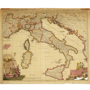
Sold2022Nicolas Sansom, map of Italy, 1701Nicolas Sansom, map of Italy, 1701, "L'Italie Divisee Suivant l'Estendue de Toutes ses Sourverainetes…", Pieter Schenk, Amsterdam, 1701, hand-colored copper plate engraving on laid paper, 20.25"See Sold Price
Sold2021Nicolas Sansom, map of Italy, 1701Nicolas Sansom, map of Italy, 1701, "L'Italie Divisee Suivant l'Estendue de Toutes ses Sourverainetes…", Pieter Schenk, Amsterdam, 1701, hand-colored copper plate engraving on laid paper, 20.25"See Sold Price
Sold2020Antique Maps by Augustus Mitchell (8)Various maps, including North America, South America, Europe, Italy, Spain, Greece, Brazil. Hand-colored engravings. S. Augustus Mitchell, Philadelphia, c. 1850. 17 1/2" x 14 1/4".See Sold Price
Sold2020Jan Jansson Hand Colored Old Map of South AmericaJan Jansson (Johannes Janssonius; Dutch, 1588-1664). Framed antique etching print of South America. Titled AMERICAE PARS MERIDIONALIS. Hand colored. Unknown printing date in two sheets joined in the mSee Sold Price
Sold2024Antique Hand-colored Harbour Plan - Map Milazzo - Sicily, Italy, MediterraneanOriginal hand-colored copper engraving print originates from "Recueil des Principaux Plans des Ports et Rades de la Mer Méditerranée …", translated from French as "CollectionSee Sold Price
Sold2022(AMERICAS.) Sebastian Münster. Die Neuwen Inseln. So Hinder Hispanien Gegeu Orient Bey Dem Land(AMERICAS.) Sebastian Münster. Die Neuwen Inseln. So Hinder Hispanien Gegeu Orient Bey Dem Land India Ligen. Hand-colored double-page woodcut map of North and South America. 12x15 inches sheet siSee Sold Price
Sold2021Early Hand-Colored Map of VeniceItaly, ca. 16th-17th century. Fine hand-colored engraved map of "Venetia" with boats in harbor and compass rose. Handsomely framed. MEASUREMENTS Sight wide: 5 7/8 / 15 cm. Sight height: 4 1/2 / 11.5 cSee Sold Price
Sold2021Early Hand-colored Maps17th- 19th c hand-colored maps ( pcs), including Ortelius "Transsylvaniae", Pieter van der Keere "Lancastria", Rapkin "Egypt and Arabia Petraea" Grassl "Californien, Texas", Rapkin "China & Burma", ovSee Sold Price
Sold2022(MEXICO.) Henry Schenk Tanner. A Map of the United States of Mexico,(MEXICO.) Henry Schenk Tanner. A Map of the United States of Mexico, As Organized and Defined by the Several Acts of Congress of that Republic. Large hand-colored lithographed map of southwestern NortSee Sold Price
Sold2022Pair hand-colored antique maps, 17th c.Pair hand-colored antique maps, 17th c., Philipp Cluver (German, 1580-1622), "Viro Antiqua domo Generoso ac Nobili: Omni Virtute pollenti...", engraving of Ancient Italy on laid paper, as two sheets jSee Sold Price
Sold2017America, Rare Early Map of the Americas"America", Rare Early Map of the Americas by Jodocus Hondius (Flemish/Dutch, 1563-1612) for a French edition of Mercator's Atlas, North and South America, hand-colored copper engraved map, published ASee Sold Price
Sold2020Jan Jansson Colored Map of Central & South AmericaJan Jansson (Johannes Janssonius; Dutch, 1588-1664). Framed antique etching print of South and Central America. Titled TERRA FIRMA ET NOVUM REGNUM GRANATENSE ET POPAYAN. Hand colored. Unknown printingSee Sold Price
Sold2016ANTIQUE NEW-FRANCE HAND COLORED MAPANTIQUE NEW-FRANCE HAND COLORED MAP, H 27 1/2" IMAGE, W 20 1/2":Framed, measures H.30" x 23" overall.See Sold Price
Sold2024Thomson's 1817 Hand Colored Map Comparative Heights of the World's Great MountainsAntique hand-colored Thomson's 1817 Map of the Comparative Heights of the World's Great Mountains framed. Good sight condition, apparent repair upper middle right. Framed, matted, and sealed under pleSee Sold Price
Sold2024Johann Homann Hand-Colored Map Engraving, c. 1730Johann Baptist Homann (German, 1664-1724), Generalis Totius Imperii Russorum, Hand-Colored Engraving, printed circa 1730, painted red frame. Image: 20" H x 23" W; frame: 27" H x 33" W. Provenance: ProSee Sold Price
Sold2024Gerard Mercator (Belgian 1512 - 1594) and Rumold Mercator (Belgian 1545 - 1599)Gerard Mercator (Belgian 1512 - 1594) and Rumold Mercator (Belgian 1545 - 1599) "Orbis Terrae Compendiosa Descriptio", circa 1595 Engraved and hand colored map 14 1/2" x 19 3/4" Condition: aging, yellSee Sold Price
Sold2024Abraham Ortelius (Belgian 1527 - 1598)Abraham Ortelius (Belgian 1527 - 1598) "Maris Pacifici", circa 1603 Hand Colored map engraving of the Pacific Ocean 14" x 20" Condition: aging, yellowing to paper, undulation, center folds, some fadinSee Sold Price
Sold2022Brassier A Survey of Lake ChamplainWilliam Brassier "A Survey of Lake Champlain", Sayer and Bennett, London, 1776 hand-colored map, plate size 26 1/2" x 19 1/4"See Sold Price
Sold2022(WEST--TEXAS.) [George F. Folsom.] Mexico in 1842 . . . to which is Added, an Account of Texas and(WEST--TEXAS.) [George F. Folsom.] Mexico in 1842 . . . to which is Added, an Account of Texas and Yucatan. Folding hand-colored map. 256 pages. 12mo, publisher's cloth, minor wear; minor foxing; earlSee Sold Price
Sold2024Abraham Ortelius (Belgian 1527 - 1598)Abraham Ortelius (Belgian 1527 - 1598) "Americae Sive Novi Orbis, Nova Descriptio", circa 1602 Copper engraved hand colored map of the Western Hemisphere 15" x 20" Condition: aging, yellowing to paperSee Sold Price
Sold20241777 Revolutionary War Map America Septentrionalis1777 hand-colored map published by Homann Heirs, Nuremberg, showing the British colonies in North American, published in the midst of the American Revolution, entitled "America Septentrionalis a DominSee Sold Price
Sold2015Cary's New Universal Atlas,Containing Distinct Maps of All the Principal States and Kingdoms, etc., London: Printed for J. Cary, Engraver, 1811, with 56 double-page engraved hand-colored maps on 60 numbered sheets (complete), rSee Sold Price
Sold2024John Speed and Francis Lamb "Map of New England and New York", ca. 1676. Hand colored engraved mapJohn Speed and Francis Lamb "Map of New England and New York", ca. 1676. Hand colored engraved map with depictions of animals such as beavers, elk, bears, foxes, and more. Vivid colors. Slight tear upSee Sold Price
Sold2017Hand-Colored Lithograph Map of the Gulf of MexicoImpressive Hand-Colored Lithograph Map of the Gulf of Mexico, titled "U.S. Coast Survey, A.D. Bache Superintendent, Sketch H, Showing the Progress of the Survey in Section No. 8, 1846-1854", the map iSee Sold Price
Jun 07Freeman's | Hindman[MAP]. TODESCHI, Pietro. [Nova et Acurata Totius Americae Tabula auct. G.I. Blaeu] America quartaUS$5,000
5 days LeftCottone AuctionsBowles and Carver, "A South-West View of the City of New York in North America" and "A South-EastUS$150
4 days LeftPandora AuctionsAntique Hand Carved Alabaster Sculpture /w Heavy Green Marble StandUS$1,500
5 days LeftFreeman's | Hindman[CIVIL WAR]. Archive of items related to Elisha Hunt RHODES (1842-1917), 2nd Rhode Island VolunteerUS$750


![(WEST--TEXAS.) [George F. Folsom.] Mexico in 1842 . . . to which is Added, an Account of Texas and: (WEST--TEXAS.) [George F. Folsom.] Mexico in 1842 . . . to which is Added, an Account of Texas and Yucatan. Folding hand-colored map. 256 pages. 12mo, publisher's cloth, minor wear; minor foxing; earl](https://p1.liveauctioneers.com/199/242021/125450317_1_x.jpg?height=310&quality=70&version=1648143591)


![[MAP]. TODESCHI, Pietro. [Nova et Acurata Totius Americae Tabula auct. G.I. Blaeu] America quarta (1 of 1)](https://p1.liveauctioneers.com/197/329395/177650542_1_x.jpg?height=282&quality=70&version=1715364962)


![[CIVIL WAR]. Archive of items related to Elisha Hunt RHODES (1842-1917), 2nd Rhode Island Volunteer (1 of 6)](https://p1.liveauctioneers.com/197/329785/177758366_1_x.jpg?height=282&quality=70&version=1715625218)

