Sold2017Map of Quebec, Rand, McNally & Co. 1898Map: Quebec Rand, McNally & Co. 1898 New Standard Atlas of the World 28 x 21.5 inches Please note that this lot has a confidential reserve. When you leave a bid in advance of the auction, submit yourSee Sold Price
Sold2023Map of Manitoba.Publication Date: 1884 Title: Map of Manitoba. Cartographer: RAND, MCNALLY & CO. Publisher: H.H. HARDESTY & CO. Height: 13.75 Width: 19.5 Double-page grid map from a scarce Hardesty atlas. Quite detaiSee Sold Price
Sold2021Manitoba 1898Title/Content of Map: Manitoba 1898 Date Printed: 1898 Material/Medium: Paper Size: approx 11x14 inches Additional Info: Rand McNally & Co. Reserve: $30.00 Shipping: Domestic: Flat-rate of $15.00 to aSee Sold Price
Sold2021Manitoba 1896Title/Content of Map: Manitoba 1896 Date Printed: 1896 Material/Medium: Paper Size: approx. 13.5x 20.5 inches Additional Info: Rand McNally Universal Atlas of the World Reserve: $30.00 Shipping: DomesSee Sold Price
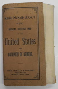
Sold2024Rand, McNally & Co.'S New Official Railroad Map of the United States And Dominion of CanadaTitle:Rand, McNally & Co.'S New Official Railroad Map of the United States And Dominion of Canada Publication Date: 1903 Cartographer:RAND, MCNALLY & CO. Publisher: RAND, MCNALLY & CO. Height: 30 WidtSee Sold Price
Sold2020Bartholomew, John 1922 Lot of 8 Maps of CanadaIncl Political, British Columbia, Alberta/Saskatchewan, Manitoba/North West Ontario, Ontario/Quebec, Maritime Provinces/Newfoundland, Western Canada, and North Eastern Canada. Large Lithograph Maps PuSee Sold Price
Sold2023Untitled. [Quebec]Publication Date: 1890 Title: Untitled. [Quebec] Cartographer: RAND, MCNALLY & CO. Publisher: JOHN B. ALDEN Height: 13 Width: 19.5 60, 61. On obverse part of Canada, on reverse, part of Ontario. FromSee Sold Price
Sold2024[CANADA, ETC.] LOT OF 35 PIECES SOLD TOGETHERCANADA, etc. A lot of approximately 35 pieces sold together. Late 19th to mid 20th century, dates vary. Condition and sizes vary. Including: maps (Quebec, 1966 TTC, Regina, Manitoba, larger map of YukSee Sold Price
Sold2016VINTAGE RAND McNALLY MAP DISPLAY w/ MAPSVery early Rand McNally display Comes full of vintage maps. 19"x7" Very GoodSee Sold Price
Sold2021Rand McNally maps rack w/ nine paper mapsEsso & Standard oil Maps from different countries in different languages, 14" tall X 19" wideSee Sold Price
Sold20211897 Rand McNally Map of Pacific Northwest -- MapTitle: 1897 Rand McNally Map of Pacific Northwest -- Map Showing Routes of the Pacific Coast Steamship Company Cartographer: Rand McNally Year / Place: 1897, Chicago Map Dimension (in.): 27 X 12.6 in.See Sold Price
Sold2024Framed Space Age Rand McNally Map of Planets Poster, 1958Framed Rand McNally Map of Outer Space Astronomy Poster, 1958. This large print of the planets and stars, with astronomical science and math facts, may have been used in a classroom school setting forSee Sold Price
Sold2017Rand McNally: Map of Texas from Jones & Hamilton AtlasEarly Rand McNally vertical format Texas map from scarce 1876 Jones & Hamilton atlas. Large and uncommon McNally vertical format map of Texas from the scarce 1876 Jones & Hamilton Historical Atlas ofSee Sold Price
Sold20181895 Rand McNally Map of Texas and Indian TerritoryTitle/Content of Map: 1895 Rand McNally Map of Texas and Indian Territory/Oklahoma -- Texas; Oklahoma and Indian Territory Date Printed: 1895 Chicago Cartographer: Rand McNally Size: 9.2 x 12.5 in. ThSee Sold Price
Sold20201898 Rand McNally Map of Texas and IndianTitle/Content of Map: 1898 Rand McNally Map of Texas and Indian Territory/Oklahoma -- Texas; Oklahoma and Indian Territory Date: 1898, Chicago Cartographer: Rand McNally Size: 9.2 x 12.5 in. This mapSee Sold Price
Sold20201892 Rand McNally Map of Chicago -- Railway TerminalTitle/Content of Map: 1892 Rand McNally Map of Chicago -- Railway Terminal Map of Chicago Cartographer: Rand McNally Year/Place: 1892, Chicago Size: 26 x 18.9 in. This is a quite large and detailed maSee Sold Price
Sold20241898 Rand McNally Map of Texas [verso] Indian Territory and Oklahoma -- Texas [verso] Oklahoma andTitle: 1898 Rand McNally Map of Texas [verso] Indian Territory and Oklahoma -- Texas [verso] Oklahoma and Indian Territory Cartographer: Rand McNally Year / Place: 1898, Chicago Map Dimension (in.): 9See Sold Price
Sold20201895 Rand McNally Map of Texas and IndianTitle: 1895 Rand McNally Map of Texas and Indian Territory/Oklahoma -- Texas; Oklahoma and Indian Territory Cartographer: Rand McNally Year/Place: 1895, Chicago Size: 9.2 x 12.5 in. Description: ThisSee Sold Price
Sold20231895 Rand McNally Map of New Orleans [verso] Louisiana -- Louisiana [verso] New OrleansTitle: 1895 Rand McNally Map of New Orleans [verso] Louisiana -- Louisiana [verso] New Orleans Cartographer: Rand McNally Year / Place: 1895, Chicago Map Dimension (in.): 12.4 X 9.4 in. This is a highSee Sold Price
Sold2017Rand McNally: Map of Indian Territory, 1882Indian Territory, Rand McNally, 1882. 13 x 19.25 inches. Signature map of Indian Territory from the exceedingly hard to find 1882 version of McNally’s Indexed Atlas of the World. Highly detailed witSee Sold Price
Sold20171911 Rand McNally Map of Brooklyn (Buffalo verso)Item: 1911 Rand McNally Map of Brooklyn (Buffalo verso) Description: A map of Brooklyn with Buffalo on verso. Highly detailed as to street names, key buildings (e.g.: Brooklyn Intitute of Arts and SciSee Sold Price
Sold2016Rand McNally: Map of Northern California, 1882Map: Northern California Maker: Rand McNally Date: 1882 Origin: Chicago Size: 19.8 x 12.8 inches Very nice map of Northern California, San Jose and north. Great deal of detail as to towns, railroads,See Sold Price
Sold20181896 Rand McNally Map of Texas and Indian TerritoryTitle/Content of Map: 1896 Rand McNally Map of Texas and Indian Territory/Oklahoma -- Texas [verso] Oklahoma and Indian Territory Date Printed: 1896 Chicago Cartographer: Rand McNally Size: 9.2 x 12.5See Sold Price
Sold2017Rand McNally Map of Italy, 18981898 Rand McNally Map of Italy. 1898, Chicago. 26 X 19 in. A nice, highly detailed map of Italy. Shown are topographical details, political divisions, settlements, transportation routes - railroads, eSee Sold Price
2 days LeftJasper52PUERTO RICO. Inset Port San Juan. RAND MCNALLY 1912 old antique map plan chartUS$15
Jul 13Cain Modern AuctionsDouble Sided U.S. Map by Rand McNally, Illustrated & Equal Area ProjectionUS$70
13 hrs LeftJasper52How The Animals Came To The Circus Elizabeth Gale 1917 RandMcNally Good Cond.US$60
Jul 28Global Auctions CompanyMarie Christine Sadler Mamma's Angel Child in Toyland Rand McNally 1915 1st EdUS$160
Jul 28Global Auctions CompanyWilliam Lightfoot Visscher, A Thrilling and truthful History of The Pony ExpressUS$60
Jul 07Worthington GalleriesTHIS IS MY COUNTRY By Felix Jones, Rare Vintage WWII Era Leather BookUS$10
Jul 25Rapid Estate Liquidators and Auction GalleryMaster And Dummies Guide To Photography Books BUS$1
Jul 25Rapid Estate Liquidators and Auction GallerySquadron Of Death & I Am Still Alive! Dick Grace BooksUS$1
5 days LeftMynt Auctions1936 Germany LZ 129 Hindenburg Zeppelin Cover Berlin to Montreal Quebec CanadaUS$100


![Untitled. [Quebec]: Publication Date: 1890 Title: Untitled. [Quebec] Cartographer: RAND, MCNALLY & CO. Publisher: JOHN B. ALDEN Height: 13 Width: 19.5 60, 61. On obverse part of Canada, on reverse, part of Ontario. From](https://p1.liveauctioneers.com/5584/283091/149355530_1_x.jpg?height=310&quality=70&version=1680038985)
![[CANADA, ETC.] LOT OF 35 PIECES SOLD TOGETHER: CANADA, etc. A lot of approximately 35 pieces sold together. Late 19th to mid 20th century, dates vary. Condition and sizes vary. Including: maps (Quebec, 1966 TTC, Regina, Manitoba, larger map of Yuk](https://p1.liveauctioneers.com/8124/322212/173234988_1_x.jpg?height=310&quality=70&version=1709937662)


![1898 Rand McNally Map of Texas [verso] Indian Territory and Oklahoma -- Texas [verso] Oklahoma and: Title: 1898 Rand McNally Map of Texas [verso] Indian Territory and Oklahoma -- Texas [verso] Oklahoma and Indian Territory Cartographer: Rand McNally Year / Place: 1898, Chicago Map Dimension (in.): 9](https://p1.liveauctioneers.com/5584/329422/177662173_1_x.jpg?height=310&quality=70&version=1715717898)

![1895 Rand McNally Map of New Orleans [verso] Louisiana -- Louisiana [verso] New Orleans: Title: 1895 Rand McNally Map of New Orleans [verso] Louisiana -- Louisiana [verso] New Orleans Cartographer: Rand McNally Year / Place: 1895, Chicago Map Dimension (in.): 12.4 X 9.4 in. This is a high](https://p1.liveauctioneers.com/5584/283091/149355547_1_x.jpg?height=310&quality=70&version=1680038985)


![1896 Rand McNally Map of Texas and Indian Territory: Title/Content of Map: 1896 Rand McNally Map of Texas and Indian Territory/Oklahoma -- Texas [verso] Oklahoma and Indian Territory Date Printed: 1896 Chicago Cartographer: Rand McNally Size: 9.2 x 12.5](https://p1.liveauctioneers.com/5584/120548/61369196_1_x.jpg?height=310&quality=70&version=1524013707)


