Sold2024American Engraved Powder Horn, N. Carolina, 1814Inscribed "D: St.: JOHN" (identified with David St. John, 1790-1873, of Norwalk, Ct.) further labeled "1813, 1814," "FORT HAMPTON," (a small battery on the Outer Banks of North Carolina) and "SLOOP INSee Sold Price
Sold2023Powder Horn with a very detailed map engraved of Northern Illinois and Eastern Iowa. Also hasPowder Horn with a very detailed map engraved of Northern Illinois and Eastern Iowa. Also has Harold Smith engraved in it.See Sold Price
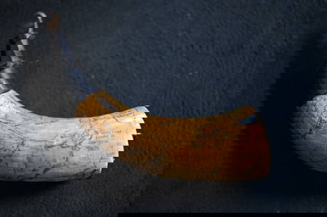
Sold2021North Carolina Powder Hornca. 1820 North Carolina powder horn with bands. 3 band design, decorated 10.5" total lengthSee Sold Price
Sold2022Very rare "hot air balloon" engraved powder horn.Very rare "hot air balloon" engraved powder horn. Belonged to John Howard and believed to be from Brookfield, Maine. This is possibly the only powder horn to depict a image of a hot air balloon. ExactSee Sold Price
Sold2021Early American Powder Horngreat patina. Early powder horn possibly North Carolina. Length 9"See Sold Price
Sold20181855 Colton Map of North Carolina -- Colton's NorthTitle/Content of Map: 1855 Colton Map of North Carolina -- Colton's North Carolina Date: 1855 New York Cartographer: J Colton Size: 12.9 X 16.4 in. An excellent and somewhat rare map of North CarolinaSee Sold Price
Sold2024American Engraved Powder Horn, Pennsylvania MapLate 18th century; engraved with with a schematic map of Pennsylvania, labeling some major towns and forts (possibly executed in the 19th century, but most likely after the Federal period); cow horn wSee Sold Price
Sold2024American Engraved Powder Horn, Philadelphia, 1775Inscribed "JOHANN / REGS ESQR. / II PA Rgt. / 1775" (identified with John Rex, 1741-1802, resident of Germantown) further engraved with a view of Philadelphia as seen from the river, with a ship and wSee Sold Price
Sold2022ANTIQUE POWDER HORNS, LOT OF FOUR,including two with flat wooden cap, one carved with "LHB", and one with square wooden cap. Together with a horn tapered drinking cup. Five pieces total. Possibly North Carolina and/or Virginia. Mid 19See Sold Price
Sold2021Bowles View of Philadelphia, Heap and ScullRare 1778 Engraved map of Colonial Philadelphia after George Heap (1714-1752) and Nicholas Scull (1687-1761), published by Carington Bowles, London, 1778: AN EAST PERSPECTIVE VIEW OF THE CITY OF PHILASee Sold Price
Sold2022American Powder HornF. McGraw, 1867 engraved with map of New York including Albany and Hudson River, 9" longSee Sold Price
Sold2017Rare 1967 Mouzon Map of North & South Carolinavery limited production by Louis and Clark Explorer Maps LLC in Kitty Hawk, and Charlotte, North Carolina. reproduction gives excellent detail and very well resembles the original map. marked "L&C" atSee Sold Price
Sold2022(AMERICAN SOUTHEAST.) Herman Moll. Carolina.(AMERICAN SOUTHEAST.) Herman Moll. Carolina. Engraved map of colonial North America from St. Augustine to the Chesapeake Bay. 8½x12 inches sheet size, ample margins; minor closure at upper edge,See Sold Price
Sold2018Colton: Antique Map of North Carolina, 1859Title/Content of Map: North Carolina Date Printed: 1859 Cartographer: H.J. Colton Material/Medium: Paper Size: 17 1/2" x 15" Hand colored,engraved. Published in New York in 'Colton's General Atlas.' PSee Sold Price
Sold2017Tanner: Antique Map of North Carolina, 1843Title/Content of Map: North Carolina by Tanner Date Printed: 1843 Cartographer: based on the work of H.C. Tanner Material/Medium: Paper Size: 17" x 14" Hand colored engraved Map. From the first editioSee Sold Price
Sold2017Colton: Antique Map of North Carolina, 1861Title/Content of Map: Colton's North Carolina Date Printed: 1861 Cartographer: J.H. Colton Material/Medium: Paper Size: 14" x 17" Hand colored, steel engraved. From 'Colton's General Atlas. PublishedSee Sold Price
Sold2024Unusual 1860 map of Virginia and N. Carolina during the Civil WarA very detailed view of the states as they existed when the country was engaged in the Civil War. An unusual map because North Carolina is rarely seen in conjunction with Virginia in American atlas maSee Sold Price
Sold2023Maps of North/South Carolina, Charleston HarborMap of North and South Carolina engraved and printed by Ferrier Sears & Co., published by J.T. Hinton, Simpkin & Marshall, 1832..Charleston Harbor Map, engraved for The American Coast Pilot, 14th editSee Sold Price
Sold2021Russell, William 1778 Rare Map. North Part of PeruCopper Engraved Map Published 1778, London for "The History of America, From Its Discovery by Columbus to the Conclusion of the Late War" by William Russell. Engraved by John Lodge. Rare. Paper Size:See Sold Price
Sold2021RARE BELLE EPOQUE TOURIST'S POCKET MAP OF PARISRare and highly collectible color-engraved pocket map of Paris's environs from a partial birds-eye view, with travel routes and vignettes depicting popular monuments and attractions. On the reverse, aSee Sold Price
Sold20231832 HINTON SIMPKIN & MARSHALL N&S CAROLINA MAP1832 HINTON SIMPKIN & MARSHALL N&S CAROLINA MAP Map of North and South Carolina engraved and printed by Ferrier Sears & Co., published by J.T. Hinton, Simpkin & Marshall in London, dated 1832.See Sold Price
Sold2023Map of the Atlantic Coast Southern StatesMap of the Atlantic Coast of the Southern States North Carolina South Carolina Constructed and Engraved to Illustrate the War with the South Print Type: EngravingSee Sold Price
Sold2024Carey, pub. 1796 - Map of the Tennassee State formerly part of North Carolina (Tennessee)This fine map engraving is from one of the ealiest American atlases published in the states: Mathew Carey's General Atlas. The work was published in Philadelphia by Carey in 1796. It was an importantSee Sold Price
Sold2022Vintage Engraved Native American Powder HornVintage Engraved Native American Powder Horn. Hand engraved/scrimshawed image of a native american. This piece does have a little bit of mouse chewing along a couple edges as shown in photos. Very nicSee Sold Price
Jun 08Early American History Auctionsc 1761, City of Boston Drawn on the Spot by his Excellency, Governor Pownal., Engraved by P.C. CanotUS$8,000
Jun 07Freeman's | HindmanMURCHISON, Roderick Impey, Sir. The Silurian System. 1839. COMPLETE WITH VERY RARE HAND-COLOREDUS$1,500
2 days LeftForum AuctionsSt. Helena.- Beatson (Maj.-Gen. Alexander) Tracts Relative to the Island of St. Helena, 1816£400
2 days LeftNY Elizabeth 1709 SEPTUAGINT GREEK BIBLE ILLUSTRATED WITH MAPS, VINTAGE VELLUM BOUND VERSIONUS$50(1 bid)
2 days LeftNY Elizabeth ANTIQUE MAP-ILLUSTRATED FLORAL ILLUSTRATION 1761 NEW DICTIONARY OF TRADE AND COMMERCE R. ROTHUS$50
4 days LeftTrillium Antique Prints & Rare BooksKohler & Weigel - Map of the World with North and South Pole viewsUS$75(1 bid)
5 days LeftSchilb Antiquarian Rare Books1832 Thomas Jefferson 1st ed Rayner Letters Correspondence Monticello PortraitUS$155(7 bids)
2 days LeftLeland LittleRare Ty Cobb (Red Portrait) 1909-1911 T206 (Old Mill Back), Tobacco CardUS$1,400(11 bids)