Sold2023Rare 19thc Census Map, U.S. Agricultural ProductionExtremely rare, original 1876 atlas map of the United States Agriculture Production - five agricultural maps (in inset form) of the production of wheat, hay, corn, cotton and tobacco. Each map distingSee Sold Price
Sold20191848 US Survey Map of Florida -- A Plat Exhibiting theTitle/Content of Map: 1848 US Survey Map of Florida -- A Plat Exhibiting the State of the Surveys in the State of Florida Date: 1848, Washington Cartographer: US State Surveys Size: 22 x 24.8 in. ThisSee Sold Price
Sold20211819 RARE Jedidiah Morse MAPS American Geography US1819 RARE Jedidiah Morse MAPS American Geography US Constitution Indians Europe Jedidiah Morse was an important and prominent geographer known for his American textbooks, books that earned him the namSee Sold Price
Sold20211805 RARE MAPS Jedidiah Morse American Geography US1805 RARE MAPS Jedidiah Morse American Geography US Constitution Indians Europe Jedidiah Morse was an important and prominent geographer known for his American textbooks, books that earned him the namSee Sold Price
Sold2018RARE 1852 CASE TIFFANY & CO. MAP OF U.S.Dated 1851 to portrait of Washington, capital added 1852. Hand-colored engraving of folding map, West in territories. Dimensions: (Frame) H 27.25" x W 29.25", (Sight) H 22.75" x W 25" Condition: ColorSee Sold Price
Sold2019Rare 1st ed./1st state decorative map, 1848From the first comprehensive physical atlas of the world. This map comes from the rare first edition/first state of “Physikalischer Atlas oder Sammlung von Karten” by Heinrich Berghaus. Full titleSee Sold Price
Sold20201947 Movie Star Hollywood/Beverly Hills MapThis rare map was a souvenir for those of us that came to Hollywood on vacation and wanted to see how our movie stars lived. Can you imagine today, having this kind of access to your favorite star? EaSee Sold Price
Sold2016Rare, 1890s Map of MaineRare map of Maine, “Freeport Sheet†by the US Geological survey from 1890. Shows islands and necks within Casco Bay as well as Freeport, Cumberland, Brunswick and surrounding towns. Matted aSee Sold Price
Sold20162 Texas Maps inc. Greenleaf, Tallis1st item: Jeremiah Greenleaf, "Texas Compiled from the Latest and Best Authorities," from a rare 1848 reissue of Greenleaf’s 1842 Universal Atlas. Greenleaf's 1842 map of Texas was based upon Burr��See Sold Price
Sold20211848 US INDIAN OMAHA EXPO 1898 $1 COIN, UNITED STATES1848 US INDIAN OMAHA EXPO 1898 $1 COIN, UNITED STATES EXPOSITION, RARE COINSee Sold Price
Sold2017Mitchell: Rare Antique Map of Asia, 1848Scarce 1848 Mitchell map of Asia. Vivid original hand coloring. Inset of Australia. Shows the entire breadth of Asia. Mitchell maps of the mid-to-late 1840s were some of the better maps produced in AmSee Sold Price
Sold2018U.S Coast Survey 1857 Map. New Orleans, Louisiana"Sketch II Showing The Progress of the Survey in Section No. VIII" A Rare Map centred on New Orleans and Lake Pontchartrain. Also showing Bon Secours Bay (Alabama) Isle au Breton Sound and Vermilion BSee Sold Price
Sold2018U.S Coast Survey 1856 Map. New Orleans, Louisiana"Sketch II Showing The Progress of the Survey in Section No. VIII" A Rare Map centred on New Orleans and Lake Pontchartrain. Also showing Bon Secours Bay (Alabama) Isle au Breton Sound and Vermilion BSee Sold Price
Sold20241848 HUGE MAP Illustrated Guide for Travelers AMERICA Cities Travel Guide RARE1848 HUGE MAP Illustrated Guide for Travelers AMERICA Cities Travel Guide RARE J Calvin Smiths “New Guide for Travelers” is a rare 19th-century travel guide with descriptions of numerous AmeriSee Sold Price
Sold20211864 American History INDIANS Mexico TEXAS Revolution1864 American History INDIANS Mexico TEXAS Revolutionary War US Map Willson Marcus Willson’s “American History” is a mid-19th-century compendium of the history of the United States from its earlSee Sold Price
Sold20191850 US History & Topography Illustrated Maps Canals US1850 US History & Topography Illustrated Maps Canals US Sea-Ports Botany John Hinton John Howard Hinton was an English author. Among his many other works, he published “The History and Topography ofSee Sold Price
Sold20181846 US History & Topography Illustrated Maps Canals US1846 US History & Topography Illustrated Maps Canals US Sea-Ports Botany John Hinton John Howard Hinton was an English author. Among his many other works, he published “The history and Topography ofSee Sold Price
Sold20181877 NEW YORK History Illustrated MAPS Steamboats US1877 NEW YORK History Illustrated MAPS Steamboats US Bridges 2v Martha Lamb “…three thousand miles from civilization, becomes within three centuries the seat of the arrogant metropolis of the WestSee Sold Price
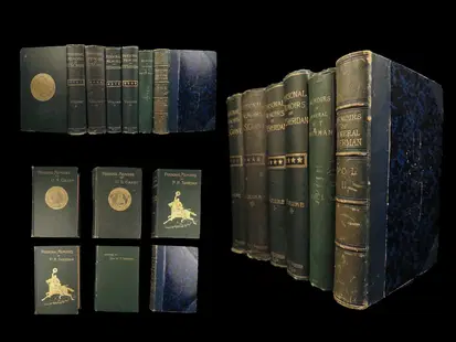
Sold20241885 CIVIL WAR 1ed Famous Memoirs US Grant Sheridan Sherman 6v RARE LOT Maps1885 CIVIL WAR 1ed Famous Memoirs US Grant Sheridan Sherman 6v RARE LOT Maps An impressive collection of the three most iconic memoirs of Union officers of American Civil War – Ulysses S Grant, PhilSee Sold Price
Sold20221848 Outstanding Mexican-American War Period MapPrints 1848 Hand-Colored U.S. & Mexico Broadside & Map titled: ORNAMENTAL MAP of the UNITED STATES & MEXICO 1848-Dated, Hand-colored Lithograph Broadside with Map titled, "ORNAMENTAL MAP OF THE UNITEDSee Sold Price
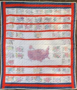
Sold2022Hand Embroidered Quilt of USA States w/ State Flower and State BirdExtremely rare hand-embroidered quilt of USA states including each state flower and state birds and each state induction date into the U.S. Map Completed 87"x84".See Sold Price
Sold2017Phelps: Antique Pre-Civil War Map of United States 1848Patriotic Antique Pre-Civil War US Map; "Phelps's National Map of the United States, A Travellers Guide. Embracing the principal Rail Roads, Canals, Steam Boat & Stage Routes, Throughout the Union.".See Sold Price
Sold20201887 Jules Verne Famous Travels & Travelers Voyage1887 Jules Verne Famous Travels & Travelers Voyage Exploration Illustrated MAPS “Reality provides us with facts so romantic that imagination itself could add nothing to them.” ― Jules VerneSee Sold Price
Sold20241869 American Emigrants Immigration Illustrated US State MAPS Railroad Alaska1869 American Emigrants Immigration Illustrated US State MAPS Railroad Alaska Frederick Goddards “Where to Emigrate and Why” is a rare, 19th-century informational treatise designed to give hinSee Sold Price
Jun 23Schilb Antiquarian Rare Books1848 Emory Military Reconnaissance 1ed California MAP Indians Texas New MexicoUS$4(4 bids)
Jun 23Schilb Antiquarian Rare Books1877 Geology Geography Surveys 1ed Nevada Wyoming Utah George Wheeler US West 2vUS$1(1 bid)
Jun 23Schilb Antiquarian Rare BooksUS War w/ SPAIN 1898 1ed Puerto Rico CUBA Philippines MAPS Russell IllustratedUS$185(4 bids)
7 hrs LeftTrillium Antique Prints & Rare BooksKarl Bodmer - Pachtuwa-Chta, An Arrikkara Warrior. 27US$300
7 hrs LeftTrillium Antique Prints & Rare BooksKarl Bodmer - Pehriska-Ruhpa, A Minaterre or Big-bellied Indian. 17US$300
7 hrs LeftTrillium Antique Prints & Rare BooksKollner, Rare - President's House, Washington, DCUS$200(1 bid)
7 hrs LeftTrillium Antique Prints & Rare BooksKarl Bodmer - Washinga Sahba's Grave on Blackbird's Hills. 12US$300
Jun 27NY Elizabeth FIRST US EDITION OF 1869 MALAY ARCHIPELAGO BY A.WALLACE, ANTIQUE ILLUSTRATED WITH MAPSUS$100
3 days LeftJasper52Production Lines are Battle Lines - Art by Chester Cobb (1942) 24x35.5 Rare US WWII Poster LBUS$1,000