Sold2015Rare Book, "Gibbsons Fall of the Roman Empire"Gibbson, Edward, "Gibbsons Fall of the Roman Empire". Elbemarle St: London, 1854. all eight volumes are in good condition and all maps are present and have good color. Main Line Philadelphia Private CSee Sold Price
Sold2023Fleetwood, Rev. John 1854 Map of Jerusalem, Holy LandSteel Engraved Map Published 1854, London for "The Life of Our Blessed Lord and Saviour Jesus Christ" by the Rev. John Fleetwood. Paper Size: 10.5 x 8 inch (27 x 21cm) Very minor margin toning. Good CSee Sold Price
Sold2017Wikes: Antique Map of Canada, 1797Title/Content of Map: 1797 Canada Date Printed: 1797 Cartographer: J. Wikes Material/Medium: Paper Size: 7 1/2" x 9 1/2" Rare Map. Published in London. Hand colored copperplate engraved. Map shows BriSee Sold Price
Sold2022Tallis, John (Pub) 1854 Map. New South Wales, AustraliaSteel Engraved Map Published 1854-55 by John Tallis, London for "The British Colonies; Their History, Extent, Condition and Resources" by Robert Montgomery Martin. Drawn & Engraved by John Rapkin. CenSee Sold Price
Sold2022Tallis, John (Pub) 1854 Map. Part of South AustraliaSteel Engraved Map Published 1854-55 by John Tallis, London for "The British Colonies; Their History, Extent, Condition and Resources" by Robert Montgomery Martin. Drawn & Engraved by John Rapkin. CenSee Sold Price
Sold2020Virginia & Maryland. I land rare map of the ChesapeakeTitle: Virginia & Maryland. I land rare map of the Chesapeake bay. Date/Period: 1732/1736 Materials: Copper plate engraved Dimensions: 13 1/2 x 9” By. H. MOLL. From atlas minor. Published. LondonSee Sold Price
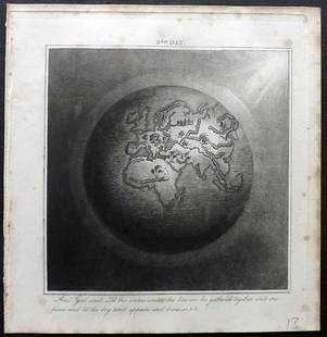
Sold2019Rhind, William 1844 Rare Map of the Old World. EarthAquatint Map Published 1844, London "The Creation: Illustrated By Six Engravings On Steel" by William Graeme Rhind. Rare. Paper Size: 6.5 x 6 inch (16.5 x 16cm) Very minor margin toning, slightly affeSee Sold Price
Sold2022Extremely rare map of Denmark by John Cooke, 1802Desirable and very rare miniature map of Denmark in a circular format, which is extremely unusual. From an 1802 edition of The Universal Atlas, published by John Cooke and J. Harris in London. Dated JSee Sold Price
Sold2023Very rare map of Norway and Sweden, John Cooke, 1802Extremely rare miniature map in an unusual circular format. From an 1802 edition of The Universal Atlas, published by John Cooke and J. Harris in London. Dated Jan. 1, 1802. Full original hand color.See Sold Price
Sold2023Extremely rare map of Germany by John Cooke, 1800Desirable and rare miniature map in a circular format. From an 1802 edition of The Universal Atlas, published by John Cooke and J. Harris in London. Full original hand color. Tiny water stain at top pSee Sold Price
Sold2021Russell, William 1778 Rare Map of The West Indies"The West Indies and Gulf of Mexico" Copper Engraved Map Published 1778, London for "The History of America, From Its Discovery by Columbus to the Conclusion of the Late War" by William Russell. EngraSee Sold Price
Sold2021Russell, William 1778 Rare Map of Mexico by Cary"A Map of the Province of Mexico in New Spain" Copper Engraved Map Published 1778, London for "The History of America, From Its Discovery by Columbus to the Conclusion of the Late War" by William RussSee Sold Price
Sold2021Russell, William 1778 Rare Map Tierra Fierma, Americas"An Exact Map of the Provinces of Tierra Fierma, Darien, C" Copper Engraved Map Published 1778, London for "The History of America, From Its Discovery by Columbus to the Conclusion of the Late War" bySee Sold Price
Sold2021Russell, William 1778 Rare Map of Mexico & Guatimala"A Map of a part of Mexico comprehending the district of or Audience of Guatimala" Copper Engraved Map Published 1778, London for "The History of America, From Its Discovery by Columbus to the ConclusSee Sold Price
Sold2021Russell, William 1778 Rare Map of Brazil by John Cary"A Map of Brasil..." Copper Engraved Map Published 1778, London for "The History of America, From Its Discovery by Columbus to the Conclusion of the Late War" by William Russell. Engraved by John CarySee Sold Price
Sold2021Russell, William 1778 Rare Map of South America"A New Map of South America" Copper Engraved Map Published 1778, London for "The History of America, From Its Discovery by Columbus to the Conclusion of the Late War" by William Russell. Engraved by JSee Sold Price
Sold2021Russell, William 1778 Rare Map Tierra Fierma, Americas"An Exact Map of the Provinces of Tierra Fierma, Darien, C" Copper Engraved Map Published 1778, London for "The History of America, From Its Discovery by Columbus to the Conclusion of the Late War" bySee Sold Price
Sold2021Russell, William 1778 Rare Map. South Part of PeruCopper Engraved Map Published 1778, London for "The History of America, From Its Discovery by Columbus to the Conclusion of the Late War" by William Russell. Engraved by John Lodge. Rare. Paper Size:See Sold Price
Sold2021Russell, William 1778 Rare Map. North Part of PeruCopper Engraved Map Published 1778, London for "The History of America, From Its Discovery by Columbus to the Conclusion of the Late War" by William Russell. Engraved by John Lodge. Rare. Paper Size:See Sold Price
Sold2015Kingdom of IrelandJohn Speed (1552-1629). Engraved map. London: 1610 (1676). 17 1/4 x 22 inches. A rare, early printing of John Speed’s renowned map of Ireland. The map is decorated with a panel of costume figures deSee Sold Price
Sold2024Map of Americas circa 1588Rare map of the Americas from the atelier of Sebastian Munster, wood block print modeled after a similar map by Ortelius. Basel, Switzerland, ca. 1588. Purchased through Sothebys, London, 2000.OverallSee Sold Price
Sold20181900 HUGE Folding Color Street Map of London 70001900 HUGE Folding Color Street Map of London 7000 Streets Visitors Travel Guide A large, color indicator map of London from the early 20th-century. This map is bound in a hardcover binding and pairedSee Sold Price
Sold20231854 MAPS Atlas 1ed World in Middle Ages CRUSADES Rome Ottoman Medieval Koeppen1854 MAPS Atlas 1ed World in Middle Ages CRUSADES Rome Ottoman Medieval Koeppen Adolph Ludwig Koeppens “World in the Middle Ages” is a rare, 19th-century perspective on the state of the woSee Sold Price
Sold2017H. Moll: Rare Antique Map of Carolina, 1746Title/Content of Map: Carolina's Rare & important Map Date Printed: 1746 Cartographer: Thomas Salmon & Herman Moll Material/Medium: Paper Size: 14 1/2" x 8 1/2" Copperplate engraved. Published in LondSee Sold Price


![[Mitchell, J. Leslie] Lewis Grassic Gibbon (1 of 1)](https://p1.liveauctioneers.com/94/330664/178342390_1_x.jpg?height=282&quality=70&version=1716466933)


![[India] Rennell, James, Major (1 of 2)](https://p1.liveauctioneers.com/94/330664/178342480_1_x.jpg?height=282&quality=70&version=1716466933)


![[The Thames] Tombleson (1 of 1)](https://p1.liveauctioneers.com/94/330664/178342457_1_x.jpg?height=282&quality=70&version=1716466933)


![[Paris] - Stanford, Edward (1 of 1)](https://p1.liveauctioneers.com/94/330664/178342455_1_x.jpg?height=282&quality=70&version=1716466933)


