Sold2021Antique New York State Map 1903 Color Roll Up RR Map1903 Scarborough's New Railroad, Post Office, Township and County Map of New York. Color map, compiled from the latest government and state surveys and original sources of the era. Insets: Map of NewSee Sold Price
Sold2023`1903 Scarborough Railroad Map of New York1903 "Scarborough's New Railroad Map of the State of New York, printed by the National Publishing Company Boston, Mass. in overall good condition 41.5" x 52See Sold Price
Sold2019Early Roll-Up New York MapEarly roll-up New York map, "SCARBOROUGH'S / NEW / RAILROAD, POST OFFICE, TOWNSHIP / AND COUNTY MAP OF / NEW YORK". Imperfections. 48" x 41"See Sold Price
Sold2023Scarborough's New York Railroad Post Office Map1903 Map is approx 44 1/2" x 49 1/2". NO SHIPPING !See Sold Price
Sold2016scarborough's map of new york 19031903 Scarborough's new railroad, post office, township and county map of New York with distances between stations. Tears; stained; needs repair. 49 1/2 inches wide x 40 inches high.See Sold Price
Sold20231902 National Publishing Company Wall Map1902 roll down wall map printed by the National Publishing Company New Railroad, Post office, Township, and County Map of New York which measures approximately 48" by 41". Condition - fine.See Sold Price
Sold2024Central Railroad of New Jersey Map of Sandy Hook Route-ca. 1903This is a Central Railroad of New Jersey Map of the Sandy Hook Route, which connected the railroad by boat to Asbury Park and the North Jersey resort communities. Excellent condition, with a fine routSee Sold Price
Sold20171875 Railroad Map Of New York1875 Railroad map of New York. Revised map of the railroads of State of N.Y.. Prepared under the direction of S.H. Sweet & D.M. Greene 1875. Hand colored. Folds as issued. 28 1/2" x 34 3/4".See Sold Price
Sold20181858 SMITH-DISTURNELL'S NEW TOWNSHIP MAP OF NYStrong color lightly aged toned paper. Showing canals and railroads. Lithograph on paper. Dimensions: H 19.5" x W 25" Condition: A few minor tears at folds.See Sold Price
Sold2022Extremely Scarce NY and Erie Railroad map, c1850Extremely scarce railroad map of the New York and Erie Railroad. The New York and Erie Railroad was chartered in 1832 on April 24 for the purpose of connecting the Hudson River at Piermont, north of NSee Sold Price
Sold2021ca. 1929 RAILROAD UNITED STATES MAP SHOWING NEW YORKVintage Railroad Map, "MAP of THE UNITED STATES SHOWING NEW YORK CENTRAL LINES". Map by Rand McNally and Co. Includes printed information on the reverse. Tiny text along bottom partly reads; "NY 4-29"See Sold Price
Sold20201940 NY CENTRAL RAILROAD CO. WAR BONDIncluding New York Central Railroad map. Bond dated 1940, 100 shares. Dimensions: H 21" x W 17" Condition: Showing normal signs of age.See Sold Price
Sold2024(45)1930s-50s Road Maps, Railroad,More - 1944 New York Central & Long Island Railroad Time Tables,(45)1930s-50s Road Maps, Railroad,More - 1944 New York Central & Long Island Railroad Time Tables, Maps - NY, Ohio, Kentucky, Tennessee, Indiana, Kansas, New Jersey + MoreSee Sold Price
Sold2022Colton’s NY, NJ, Penn. & Delaware 1860s school atlas mapUnusually sound and clean J. H. Colton school atlas map of New York, New Jersey, Pennsylvania and Delaware from an 1864 edition of J. H. Colton’s School Atlas. Shows railroads, rivers, battlefieSee Sold Price
Sold2018[Railroads, NY & PA] 19th c. ProspectusProspectus for the Tioga Railroad from New York to Pennsylvania. March 16, 1832. 4to, 2 pp., containing a map and details regarding the proposed construction of the railroad (particularly the need forSee Sold Price
Sold2021Carl Rose Greenwich Village Street Map, Landmark'sOriginal Carl Rose signed Illustration Pen & ink street map of Greenwich Village NY with Landmarks Carl Rose (1903 - 1971) was an American cartoonist whose work appeared in The New Yorker, Popular SciSee Sold Price
Sold2018New York Central & Hudson River Railroad. 1903.Reserve Reduced! Item: New York Central & Hudson River Railroad. 1903. Date: 1903 Cartographer: MATTHEWS-NORTHRUP Publisher: NYC&HR R.R. Size (inches): 20.5X35.75 Large map with routes shown in colorsSee Sold Price
Sold2021A Tiffany Studios bronze and Favrile glass candlestickLate 1902/early 1903; New York, NY Signed: Tiffany Studios / New York / [T.G.D.Co. monogram] / B 26522 The gold iridescent Favrile glass capital with trailing lily pad motif raised on a patinated brSee Sold Price
Sold2023Mauser Mfg. Co Sterling Silver Center BowlFine American Sterling Silver Center Bowl, Mauser Mfg. Co., New York, NY, 1887-1903, lobed form with everted reticulated serpentine rim applied with wreath of roses, interior retains traces of gilt waSee Sold Price
Sold2021Attributed to Keith Haring (Baby) Ink on NY Map 1988ATTRIBUTED TO KEITH HARING 21 1/2" x 26" Ink on New York Map (1988)See Sold Price
Sold2023Antique Framed Wayfarer's Map of New York 1939Antique Framed Wayfarer's Map of New York 1939. Framed. Signed by Charles D. Graves, possibly the map maker. Copyrighted 1939, Herbert C. Wyman, Pleasantville, NY. Wayfarer's Maps.See Sold Price
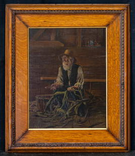
Sold2020Thomas Waterman Wood (1823 - 1903) NY Artist OilThomas Waterman Wood (1823 - 1903) Thomas Waterman Wood was active/lived in New York, Kentucky. Thomas Wood is known for genre, portrait, and figure painting, etching. Medium: Oil on board Size: 13 1/See Sold Price
Sold20151867 Map of California and NevadaLeander Ransom & Amos Doolittle: A New Map of the States of California and Nevada, Exhibiting the Rivers, Lakes, Bays and Islands, with the principal Towns, Roads, Railroads and Transit Routes to theSee Sold Price
Sold2020Des Barres Map of NY Harbor*** START PRICE IS THE RESERVE *** [America] DES BARRES, Joseph Frederick Wallet (1729-1824). A Chart of New York Harbour with the Soundings Views of Land Marks and Nautical directions for the Use ofSee Sold Price
Jun 29JM Hobby Supply and Railroad Artifact AuctionsNew York Central RR Tall Copper and Brass Fire ExtinguisherUS$50(1 bid)
Jun 29JM Hobby Supply and Railroad Artifact AuctionsFour Mixed Railroad Shovels/Picks/Pitchforks-NYC/DH/DLW//BRPUS$10


![[Railroads, NY & PA] 19th c. Prospectus: Prospectus for the Tioga Railroad from New York to Pennsylvania. March 16, 1832. 4to, 2 pp., containing a map and details regarding the proposed construction of the railroad (particularly the need for](https://p1.liveauctioneers.com/3532/125343/63770800_1_x.jpg?height=310&quality=70&version=1532476745)


![A Tiffany Studios bronze and Favrile glass candlestick: Late 1902/early 1903; New York, NY Signed: Tiffany Studios / New York / [T.G.D.Co. monogram] / B 26522 The gold iridescent Favrile glass capital with trailing lily pad motif raised on a patinated br](https://p1.liveauctioneers.com/255/217961/111820907_1_x.jpg?height=310&quality=70&version=1631299268)


![Des Barres Map of NY Harbor: *** START PRICE IS THE RESERVE *** [America] DES BARRES, Joseph Frederick Wallet (1729-1824). A Chart of New York Harbour with the Soundings Views of Land Marks and Nautical directions for the Use of](https://p1.liveauctioneers.com/1968/163248/82424572_1_x.jpg?height=310&quality=70&version=1583340284)


