Sold2017Scarce Map of Texas, New Mexico and ArizonaItem: Scarce Map of Texas, New Mexico and Arizona Description: Scarce Map of Texas, New Mexico and Arizona from Wallings's 1868 State Atlas of Ohio Dimensions: 14.25 x 26.25 Please note that this lotSee Sold Price
Sold2023RR map of New Mexico from scarce 1898 Cram’s Atlas.Large and dramatic double-page map of New Mexico naming and showing all rail lines in the state. Every railroad line is named, numbered, and color-coded by a legend on the map. From the very scarce CrSee Sold Price
Sold2022Scarce Johnson map of the Great Western states, 1864Antique map of California, Nevada, Utah, Colorado, New Mexico, and Arizona. Published during a great time of expansion and change in the U.S. West, as well as during the Civil War. Here Utah displaysSee Sold Price
Sold2023Scarce Johnson map of the Great Western states, 1864Authentic vintage map of California, Utah, Nevada, Colorado, New Mexico, and Arizona. Created during a great time of expansion and change in the western United States while the Civil War was still ragSee Sold Price
Sold2022Scarce Hardesty map of Southwest US, 1875Great map of the West, noting copper, silver and gold regions throughout southern Arizona and New Mexico. “Map of Colorado, Utah, New Mexico and Arizona,” by J. David Williams. Published 1875 by HSee Sold Price
Sold2023Dripps' Map of the Five Cities New York, Brooklyn, Long Island City 19th Century folding pocket mapA rare and scarce folding pocket map showing a "MAP OF THE CITIES OF NEW YORK, BROOKLYN, LONGISLAND CITY, JERSEY CITY & HOBOKEN" published by "M. DRIPPS, 103 FULTON ST. N. Y." with a catalogue of M. DSee Sold Price
Sold2017Jones & Hamilton Antique Map of New Mexico, 1876From the scarce 1876 Jones & Hamilton Historical Atlas of the World Illustrated comes an early color map of New Mexico, possibly by Keith Johnston. Very detailed in both topographical features and infSee Sold Price
2022Scarce 1833 Finley map of Mexico – fine exampleExtremely scarce map of Mexico depicting Texas territory just three years before it gained its independence. Shows major portion of western America still belonging to Mexico, including New Albion andSee Sold Price
Sold2023Scarce 1833 Finley map of Mexico – fine exampleExtremely scarce map of Mexico depicting Texas territory just three years before it gained its independence. Shows major portion of western America still belonging to Mexico, including New Albion andSee Sold Price
Sold2017Colton’s Territories of New Mexico & UtahColton’s Territories of New Mexico and Utah (8th state) Copyright 1855 but pub. C1859-60. Scarce issue of Colton's great map of the American Southwest featuring the provisional territory of Colona,See Sold Price
Sold2016A Map of the United States & MexicoHenry Tanner (1786-1858). New York: Tanner, 1850. Hand-colored Pocket Map. 23 x 29 inches visible, 38 x 39 1/2 inches framed.See Sold Price
Sold2023Long Vest Chimayo Weaving from Ortega'sLabeled "Ortega's" from Chimayo New Mexico. A long vest or sleeveless coat made from a Chimayo wool weaving. It has 4 woven leather buttons and pockets at the hip. Marked size large. Overall length 46See Sold Price
Sold2023Scarce pocket map of Western States, 1855Important and beautiful pocket map in completely sound condition after numerous conservation repairs using the kozo method that will last hundreds of years. Presents very well. Decorative and intricatSee Sold Price
Sold2020Scarce pocket map of Missouri, 1855Title: Scarce pocket map of Missouri, 1855 Description: Beautiful and scarce pocket map of Missouri, published 1855 by J. H. Colton. Hand-colored by county. Toning where glued into pocket. Three tinySee Sold Price
Sold2023Underground Water Map New Mexico Carlsbad SheetPublication Date: 1899 Title: Underground Water Map New Mexico Carlsbad Sheet Cartographer: GARDNER, FRANK D./JOHN STEWART Publisher: U.S. DEPT. AGRICULTURE Height: 21 Width: 15.75 Area geologic map.See Sold Price
Sold2019Harrison Begay (AZ,NM,1914-2012) gouache paintingARTIST: Harrison (Haskay Yahne Yah) Begay (Arizona, New Mexico, 1914 - 2012) NAME: Girl with Lamb MEDIUM: gouache on paper CONDITION: Excellent. Framed under glass. SIGHT SIZE: 12 x 9 inches / 30 x 23See Sold Price
Sold2018Colton's MaineTitle: Colton's Maine Publication Date: 1872 Cartographer: COLTON, G.W. & C.B. Publisher: G.W. & C.B. COLTON & CO. Size: 14X11 Scarce Pocket Map of Maine. Map detailing counties, many towns, townshipsSee Sold Price
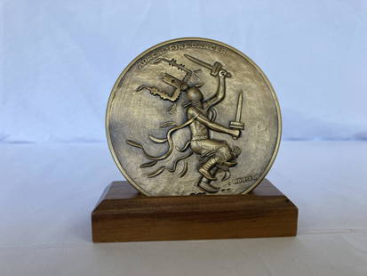
Sold2023ALLAN CAPRON HOUSER Bronze Metal Sculpture APACHE FIRE DANCER Medallic Art LIMITED EDITIONARTIST: Allan Capron Haozous Houser (Chiricahua Apache, Fort Sill, Oklahoma, Santa Fe, New Mexico, 1914-1994) TITLE: Apache Fire Dancer, Apache Buffalo Hunt MEDIUM: Bronze Medal Sculpture OVERALL SIZESee Sold Price
Sold2017Colton: Antique Map of New Mexico & Utah, 1859Title/Content of Map: New Mexico & Utah with today's Arizona & Nevada Date Printed: 1859 Cartographer: H. J. Colton Material/Medium: Paper Size: 17 1/2" x 15" Hand colored engraved. Published in New YSee Sold Price
Sold2023ALLAN CAPRON HOUSER Bronze Metal Sculpture APACHE FIRE DANCER Medallic Art LIMITED EDITIONARTIST: Allan Capron Haozous Houser (Chiricahua Apache, Fort Sill, Oklahoma, Santa Fe, New Mexico, 1914-1994) TITLE: Apache Fire Dancer, Apache Buffalo Hunt SIZE: Medallion circumference, 3" MEDIUM: BSee Sold Price
Sold2022New Mexico & Indian Terratory 1889Title/Content of Map: New Mexico & Indian Terratory 1889 Date Printed: 1889 Material/Medium: paper Size: approx 10.5"x13.50" Additional Info: Mast, Crowell & Kirkpatrick Reserve: $35.00 Shipping: DomeSee Sold Price
Sold2020New Mexico, Indian Terratory 1889Title/Content of Map: New Mexico, Indian Terratory 1889 Date Printed: 1889 Material/Medium: paper Size: approx 13.5x11 inches Additional Info: The Peerless Atlas. Published by Mast, Crowell & KirkpatrSee Sold Price
Sold2020New Mexico 1896Title/Content of Map: New Mexico 1896 Date Printed: 1896 Material/Medium: paper Size: approx. 10.5x 13.5 inches Additional Info: Rand McNally & Co. Universal Atlas of the World Reserve: $25.00 ShippinSee Sold Price
Sold20161881 Rand, McNally and Co. New Mexico Map1881 Rand, McNally and Co. (Atlas Maps): ''New Mexico'' Map c. 1881, measures 19'' x 13'', color coded land tenureSee Sold Price
Jun 11Jasper521887 Mitchell Map of New Mexico and Arizona -- County and Township Map of Arizona and New MexicoUS$80
3 days LeftHolabird Western Americana CollectionsPyramid Lake Print Pair & 1885 NM & UT Territory Map [179398]US$150
Jun 23Schilb Antiquarian Rare Books1848 Emory Military Reconnaissance 1ed California MAP Indians Texas New MexicoUS$3(3 bids)
4 days LeftSimpson Galleries, LLC.JULIUS BIEN (1826-1909) AN AMERICAN CIVIL WAR RECONNAISSANCE MAP, "Map of Texas and Part of NewUS$100
Jun 13Swann Auction Galleries(NEW YORK -- ADIRONDACK MOUNTAINS.) Seneca Ray Stoddard. Map of the Adirondack Wilderness.US$375
4 days LeftTrillium Antique Prints & Rare BooksKohler & Weigel - Map of Louisiana Territory or Eastern United States (extends from New Mexico toUS$120(4 bids)
Jun 13Swann Auction Galleries(NEW YORK CITY.) G.W. Colton; and J.M. Atwood. Map of the Country Thirty Three Miles Around the CityUS$600
Jun 13Swann Auction Galleries(UNITED STATES.) John M. Atwood. Phelps's National Map of the United States, A Travellers Guide.US$450


![Pocket Map of Richland Co., OH c1910 [180795] (1 of 3)](https://p1.liveauctioneers.com/2699/331495/178785767_1_x.jpg?height=282&quality=70&version=1717094933)

![1885 Cram Map of New Mexico [verso] Arizona -- New Mexico [verso] Arizona (1 of 2)](https://p1.liveauctioneers.com/5584/331526/178834526_1_x.jpg?height=282&quality=70&version=1717530687)

![Pyramid Lake Print Pair & 1885 NM & UT Territory Map [179398] (1 of 2)](https://p1.liveauctioneers.com/2699/331495/178785761_1_x.jpg?height=282&quality=70&version=1717094933)


![Arizona & New Mexico RY Co pass, 1914 [182668] (1 of 2)](https://p1.liveauctioneers.com/2699/331495/178785822_1_x.jpg?height=282&quality=70&version=1717094933)
![Arizona/New Mexico Map, 1883 [181626] (1 of 2)](https://p1.liveauctioneers.com/2699/331495/178785769_1_x.jpg?height=282&quality=70&version=1717355373)


![Wah To Yah & The Taos Trail [181869] (1 of 5)](https://p1.liveauctioneers.com/2699/331494/178785312_1_x.jpg?height=282&quality=70&version=1717094654)
