Sold2022(NEW YORK CITY -- FRESH WATER SUPPLY.) James C. Spencer, et al. Report to the Aqueduct Commissioners(NEW YORK CITY -- FRESH WATER SUPPLY.) James C. Spencer, et al. Report to the Aqueduct Commissioners of New York City. Profusion of maps, tables, photographs, and schematic plans (many folding, severaSee Sold Price
2017The Great Salt Lake (Mormon) CityDescription: The Great Salt Lake (Mormon) City. Town plan & environs maps. WELLER, 1863 Dimensions: Approx 44.5 x 31.5cm, 17.5 x 12.25 inches Please note that this lot has a confidential reserve. WhenSee Sold Price
Sold2022PAIR OF WILLIAM STARLING BURGESS SHIP PLANS Early 20th Century 22.5" x 35.5" and 17.75" x 42.5"PAIR OF WILLIAM STARLING BURGESS SHIP PLANSEarly 20th CenturyHull and deck plans for a cruising sloop.22.5" x 35.5" and 17.75" x 42.5" sight. Framed 30" x 43.5" and 25.5&See Sold Price
Sold2024William Shatner Enterprise Ships schematic signedA lrge Enterprise ships schematic poster 24x36 signed by Shatner adding Capt Kirk with our COA from our exclusive signing and Beckett Witnessed stickerSee Sold Price
Sold2018ANTIQUE MODEL CLIPPER SHIPMarked with plaque on model base: Builder H. L. Wheeler 1920. With signed letter from builder stating ship plans were adapted from original design of Donald McKay's clipper ship "Sovereign of the OceaSee Sold Price
Sold2018Plan De Plusieurs Batimens der MerPlan De Plusieurs Batimens de Mer, Avec Leurs Proportions Par Henri Sbonki de Passebon. To include a cover sheet, introduction sheet, and 17 loose colored etchings of ship plans. In a hardcover portfoSee Sold Price
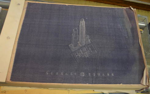
2019I.M. Pei Original Architectural Drawings US BANKSchematics and plans for The US Bank Tower, Library Square, Los Angeles, CA. 1986. In excess of 500 pages, with three addendums. All binded, in good condition. On heavy 15 1/4" x 30" paper.See Sold Price
Sold2020Prag.Plan des Environs de Prague et des Camps des deux Armées. Kupferstichplan bei Le Rouge, Paris 1742. 48,5 x 56 cm. Mit herald. Titelkart. unt. li. u. Legende 1-31 ob. li. - Vereinz. stockfl., FalzSee Sold Price
Sold2022London.- Walker (J. & C.) A Plan of London and itsLondon.- Walker (J. & C.) A Plan of London and its Environs, decorative plan centered on Blackfriar's Bridge after Creighton, from Lewis's Topographical Dictionary, engraving with hand-colouring, sheeSee Sold Price
Sold2022(NEW ORLEANS.) Benjamin Moore Norman. Norman's Plan of New Orleans & Environs.(NEW ORLEANS.) Benjamin Moore Norman. Norman's Plan of New Orleans & Environs. Finely detailed hand-colored engraved pocket map of New Orleans with an 86-point keyed reference panel. 17¾x24½See Sold Price
Sold2018Nouveau Plan De ParisTitle: Nouveau Plan De Paris Publication Date: 1872 Cartographer: LOGEROT, AUGUSTE Publisher: AUG. LOGEROT Size: 29.25x42.5 divise en 20 arrondissements. Wall Size Plan of Paris and Environs. Large diSee Sold Price
Sold20241777 map of Philadelphia "A Plan of the City and Environs of Philadelphia, Engraved and Published by1777 map of Philadelphia "A Plan of the City and Environs of Philadelphia, Engraved and Published by Matthew Albert Lotter 1777". Signed in pencil "Scull and Heap" SCULL, Nicholas; and George HEAP. ExSee Sold Price
Sold2022(QUEBEC.) William Faden. Plan of the City and Environs of Quebec with Its Siege and Blockade by the(QUEBEC.) William Faden. Plan of the City and Environs of Quebec with Its Siege and Blockade by the Americans. Large engraved plan of American positions during their failed raid on the British stronghSee Sold Price
Sold2024Goerck's 1785 working survey of the Common Lands that became Fifth Avenue[MAP-NEW YORK] [GOERCK, CASIMIR, attributed to]. A manuscript survey of the Manhattan Common Lands, dated 1785. A manuscript survey plan in ink on joined sheets, with irregular edges but the image subSee Sold Price
Sold2021France.- Paris.- Collection of 20 plans of Paris andNO RESERVE France.- Paris.- Collection of 20 plans of Paris and its environs, including a large panorama 'Paris 1867' by The London Illustrated News, and plans by Calignam, Edward Stanford, and othersSee Sold Price
Sold2021◎§ ERTÉ (ROMAN DE TIRTOFF) (1892-1990)Costume Design Pencil and gouache on paper, 34 by 22 cm., signed. Provenance: Important private collection, Europe. Note: This item ships from Monaco. Please plan accordingly for any additional fees.See Sold Price
Sold2017Fine example of Lotter's edition of Scull & Heap'sPlan of the City and Environs of Philadelphia... Nicholas Scull & George Heap. Hand-colored engraving. Augsburg: Matthew Albert Lotter, 1777. 24 x 18 1/2 inches visible, 32 x 26 1/2 inches framed. FinSee Sold Price
Sold2018Civil War plan of London as fortified by Parliament inTITLE/CONTENT OF MAP: 'A plan of the city and environs of London as fortified by order of Parliament in the years 1642 & 1643' Date: 1776 IMAGE SIZE: Approx 21.5 x 33.5cm, 8.5 x 13.25 inches (Large) TSee Sold Price
Sold20201928 New York Map of Graphic Region Plan1928 New York Cartograph of Graphic Region Plan, New York and its Environs, committee member names also listed below 1928. Made by Williams and Heintz and Company, Washington DC. Depicting parts of thSee Sold Price
Sold20231808 Published, Illustration Plan and Sections of a Slave Ship by engraver William Kneass, Phila.Black History Illustration Plan and Sections of a Slave Ship as Published by J. P. Parke, Copper-Plate Engraved by Kneass, Philadelphia 1808 Published, Historic Illustration Plan and Sections of a SlaSee Sold Price
Sold2021Plan of Fort Niagara and its EnvironPlan of Fort Niagara and its Environ Print Type: Engraving Dimensions: 4 3/4 x 9" Condition Report: Considerable foxing Subject References: ASee Sold Price
Sold2022[MAP-CUBA] KITCHIN, THOMAS. Plan of the Havana and its Environs, with the several posts and attacks[MAP-CUBA] KITCHIN, THOMAS. Plan of the Havana and its Environs, with the several posts and attacks made by the British Forces; under the command of the Earl of Albemarle and Sr. Geo. Pocock, which waSee Sold Price
Sold2016SOLEIL ROYALE Model Ship FrenchReplica of ship built in 1669 fm plans by L. HUBAC Commanded by Thomas Heath. Measures 31 x 30 x 14See Sold Price
Sold2019Carte de Bombay et de ses environs'. Mumbai India ThaneTITLE/CONTENT OF MAP: 'Plan de Bombay et de ses environs tiré de Thornton Hyd. Ang [Map of Mumbai and its environs]' DATE PRINTED: 1751 IMAGE SIZE: Approx 20.5 x 27.5cm, 8 x 10.75 inches (Medium); PlSee Sold Price
5 days LeftRail & Road AuctionsEleven United States Lines & American Merchant Lines Travel Guides, Brochures, Rates, Menus, andUS$30
May 18Blackstone Valley Auctions & Estates LLCRevolutionary Era War Map of the Attack on Ft. Moultrie.US$120(2 bids)
5 days LeftRail & Road AuctionsFive Nautical Publications and Blueprints - Nippon Kaiji Kyokai Japan, Society of Naval ArchitectsUS$10
5 days LeftHermann Historica GmbHA ship wall clock of the German navy, manufacturer Kieninger & Obergfell€1,700
6 days LeftBoston Harbor Auctions Ship Model Caroline, The Royal Yacht Of George II and George IIIUS$1,600(2 bids)
1 day LeftHudson Valley Auctioneers LLC Beacon NYArchitectural drawings, blue prints, The Buddhist Association of the United States, temple plansUS$20
1 day LeftHudson Valley Auctioneers LLC Beacon NYSail ship diorama, 4 masted sail ship with full sails, flying US flag, diorama is 21" by 35.5"US$120(6 bids)


![Goerck's 1785 working survey of the Common Lands that became Fifth Avenue: [MAP-NEW YORK] [GOERCK, CASIMIR, attributed to]. A manuscript survey of the Manhattan Common Lands, dated 1785. A manuscript survey plan in ink on joined sheets, with irregular edges but the image sub](https://p1.liveauctioneers.com/292/326828/175962863_1_x.jpg?height=310&quality=70&version=1713473479)


![[MAP-CUBA] KITCHIN, THOMAS. Plan of the Havana and its Environs, with the several posts and attacks: [MAP-CUBA] KITCHIN, THOMAS. Plan of the Havana and its Environs, with the several posts and attacks made by the British Forces; under the command of the Earl of Albemarle and Sr. Geo. Pocock, which wa](https://p1.liveauctioneers.com/292/250642/130213656_1_x.jpg?height=310&quality=70&version=1654271664)

![Carte de Bombay et de ses environs'. Mumbai India Thane: TITLE/CONTENT OF MAP: 'Plan de Bombay et de ses environs tiré de Thornton Hyd. Ang [Map of Mumbai and its environs]' DATE PRINTED: 1751 IMAGE SIZE: Approx 20.5 x 27.5cm, 8 x 10.75 inches (Medium); Pl](https://p1.liveauctioneers.com/5584/144578/73088416_1_x.jpg?height=310&quality=70&version=1561513819)


