Sold2023Rare 1721 John Senex "A New Map Of The World"DESCRIPTION: Rare antique engraved map by John Senex entitled "A New Map of the World" depicting California as an island and with parts of the world still unmapped. Further featuring hand coloring, foSee Sold Price
Sold2021Map of Turky, Arabia and Persia. Corrected from the[In A New general atlas : containing a geographical and historical account of all the empires, kingdoms and other dominions of the world, by John Senex][London, 1721]47 cm x 57 cm Watermarked paper. OSee Sold Price
Sold202218th C. John Senex Map of India and ChinaJohn Senex map, London, 1721, "A New Map of India & China", outlining the area, and including Japan, Malay Peninsula and Southeast Asia, unframed. [Sheet: 21 1/4" H x 25" W]. In distressed condition,See Sold Price
Sold2020John Senex Map of North and South America 1719-17John Senex (1678–1740), "A New Map of America from the Latest Observations," London, ca. 1719-1721. Hand colored copperplate engraved map of North and South America, from Senex's "New General ASee Sold Price
Sold20221721 Senex Map of British Caribbean Islands -- A New Map of the English Empire in the Ocean ofTitle: 1721 Senex Map of British Caribbean Islands -- A New Map of the English Empire in the Ocean of America or West Indies Cartographer: J Senex Year/Place: 1721, London Dimensions: 20.1 X 23.8 in.See Sold Price
Sold2018Senex: Antique Map Jamaica & British West Indies, 1721Title/Content of Map: A new map of the English Empire in the Ocean of America or West Indies Cartographer: J. Senex Place & Date: London / 1721 Size: 23 3/4" x 20" Condition: full wash color; repairedSee Sold Price
Sold2021Guthrie, William 1806 Map. World HemispheresCopper Engraved Map Published 1806, London for "A New Geographical, Historical and Commercial Grammar..." by William Guthrie. The maps are by John Senex, Thomas Kitchin and others. Folds as issued. PaSee Sold Price
Sold2021Guthrie, William 1798 Map. World HemispheresCopper Engraved Map Published 1798, London for "A New Geographical, Historical and Commercial Grammar..." by William Guthrie. The maps are by John Senex, Thomas Kitchin and others. Folds as issued. PaSee Sold Price
Sold2021Guthrie, William 1798 Map World of Mercators ProjectionCopper Engraved Map Published 1798, London for "A New Geographical, Historical and Commercial Grammar..." by William Guthrie. The maps are by John Senex, Thomas Kitchin and others. Folds as issued. PaSee Sold Price
Sold2024Two Maps of The Golden Islands and Ismuth of Darien by John Senex (London, 1721)Two Maps of The Golden Islands and Ismuth of Darien by John Senex (London, 1721) Two engraved maps by John Senex (British, 1678-1740 ), published in A New General Atlas, London, 1721. Including "A DraSee Sold Price
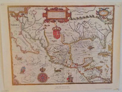
Sold2022John Senex Map of Louisiana & Mississippi River 1721John Senex (English, 1678-1740). "Map of Louisiana and the River Mississippi," from "A New General Atlas," London, 1721. Dedicated to William Law of Lanreston. This map is an EngliSee Sold Price
2022Blaeu, Johannes (Netherlands, 1596-1673) "The New World Map" Double Hemisphere World Map C. 1664Nova et Accuratissima Totius Terrarum Orbis Tabula Translated "The New World Map", Hand Colored w/ Elaborately Decorated Spandrels.   Sight View 16" x 21-1/2", Overall View 21" x 25-1/2"See Sold Price
Sold2022Herman Moll's New Map of the World - California as an Island!, Ca. 1725Herman Moll's New Map of the World - California as an Island!, Ca. 1725 1p, measuring 13.625" x 8.5", n.p., ca. 1725. A hand-colored map entitled "A New Map of the World according to the New ObservatiSee Sold Price
Sold20211721 Senex Map of Sicily and Malta -- A Map of theTitle: 1721 Senex Map of Sicily and Malta -- A Map of the Island and Kingdom of Sicily from the Latest Observations Cartographer: J Senex Year / Place: 1721, London Map Dimension (in.): 19 X 23 in. ThSee Sold Price
2017New Map of the World with Captain Cooks Tracks, 1794New Map of the World with Captain Cooks Tracks, Western & Northern Hemisphere. 40 x 30 in. dated May 11, 1794. Reproduction. Please note that this lot has a reserve. When you leave a bid in advance ofSee Sold Price
Sold20201721 Senex Map of the Atlantic Side of Panama -- ATitle/Content of Map: 1721 Senex Map of the Atlantic Side of Panama -- A Draft of the Golden & Adjacent Islands, with part of ye Isthmus of Darien as it was taken by Capt. Ieneser. Where ye Scots WestSee Sold Price
Sold20191782 New Map of the World Navigation Routes“A New Map of the World in Three Sections wherein the several tracks and discoveries of the British Navigators to the present time are distinctly and accurately laid down”, by J. Bayly, printed atSee Sold Price
Sold20181782 A New Map of the World1782 "A New Map of the World", double hemisphere map published by Harrison and Co., London, 1782. Folding map, measures 17 x 10". Fine, mild discoloration. Reserve: $80.00 Shipping: Domestic: Flat-ratSee Sold Price
Sold20191782 A New Map of the World1782 “A New Map of the World”, double hemisphere map published by Harrison and Co., London, 1782. Folding map, measures 17 x 10”. Fine, mild discoloration. Reserve: $80.00 Shipping: Domestic: FlSee Sold Price
Sold2019John Senex (1678-1740), "A New Map of the EnglishJohn Senex (1678-1740), "A New Map of the English Empire in the Ocean of America or West Indies, A New Map of the Island of Jamaica," c. 1798, hand colored, H.- 22 in., W.- 26 1/4 in.See Sold Price
Sold2019New World Map Jig-Saw PuzzleReserve Reduced! Title/Content of Map: New World Map Jig-Saw Puzzle Date: c1940 Material/Medium: H. M. Gousha Size: 26Height - 43Width Box title: New World Map Jig-Saw Puzzle / 8 colors / (size 43 in.See Sold Price
Sold2019John Senex (1678-1740), "A New Map of the Provinces ofJohn Senex (1678-1740), "A New Map of the Provinces of Hainault, Namur, and Cambray," 1710, hand colored, H.- 20 1/4 in., W.- 26 1/4 in.See Sold Price
Sold2017Gabriel Tatton: The New World Map, 1600The New World Map 1600” drawn by Gabriel Tatton - reproduction by American Heritage, the magazine of history. Measurement approximate: 24” x 18”. Condition: Very Good Please note that this lSee Sold Price
Sold2022Buffon & Tardieu 1853 Map. New World"Carte de Nouveau Continent" Steel Engraved Map with outline hand color Published 1853-55, Paris for "Oeuvres Completes de Buffon" by the Comte de Buffon. Engraved by Ambroise Tardieu. Paper Size: 10See Sold Price
May 14Akiba Galleries(2 Pc) Allain Manesson Mallet Description De L'Univers 2 Vol. German TranslationUS$200(1 bid)
2 days LeftJasper52New Map of That Portion of North America Exhibiting the United States and Territories...Mexico...US$360
May 16Potter & Potter Auctions[NEW YORK CITY – PICTORIAL MAPS]. Group of 3 pictorial maps...US$200(1 bid)
Featured2 days LeftJasper521719 Chatelain World Map -- Mappe-Monde pour Connoitre les Progres & les Conquestes les PlusUS$280
2 days LeftJasper52c1720 World showing Dutch East India Co possessions. CA as a island. By J.MalherbeUS$650
3 days LeftJasper52MELANESIA.New Caledonia.Ponérihouen-Bourail.WW2 ROYAL NAVY INTELLIGENCE MAP 1944US$10
3 days LeftJasper52MELANESIA. New Caledonia. Comboui-Noumea. WW2 ROYAL NAVY INTELLIGENCE MAP 1944US$10
May 16Potter & Potter AuctionsBOLLMANN, Hermann (1911 – 1971). Map of New York City. 1962.US$100
6 days LeftTrillium Antique Prints & Rare BooksCarey, pub. 1814 - Map of the East Indies with India, China, & New Holland (Australia)US$50(1 bid)
6 days LeftTrillium Antique Prints & Rare BooksCarey, pub. 1814 - Map of New South Wales, AustraliaUS$50
6 days LeftTrillium Antique Prints & Rare BooksMitchell's A New Universal Atlas.. - Volume with 73 MapsUS$1,000(1 bid)
Featured3 days LeftJasper52Bismarck Archipelago New Guinea New Britain 1943/4. Ports. World War 2 1961 mapUS$8
3 days LeftJasper52New Guinea-Solomon Islands 1942/3. Pacific Campaign. World War 2 1961 old mapUS$10
May 09Hunt and Peck Estate Services, Inc.Abraham Ortelius map of Bitiurigum from Theatrum Orbis TerrarumUS$50


![Map of Turky, Arabia and Persia. Corrected from the: [In A New general atlas : containing a geographical and historical account of all the empires, kingdoms and other dominions of the world, by John Senex][London, 1721]47 cm x 57 cm Watermarked paper. O](https://p1.liveauctioneers.com/6940/190006/95714289_1_x.jpg?height=310&quality=70&version=1609447005)
![18th C. John Senex Map of India and China: John Senex map, London, 1721, "A New Map of India & China", outlining the area, and including Japan, Malay Peninsula and Southeast Asia, unframed. [Sheet: 21 1/4" H x 25" W]. In distressed condition,](https://p1.liveauctioneers.com/1221/258471/135401029_1_x.jpg?height=310&quality=70&version=1661963765)


![[NEW YORK CITY – PICTORIAL MAPS]. Group of 3 pictorial maps... (1 of 3)](https://p1.liveauctioneers.com/928/325952/175495562_1_x.jpg?height=282&quality=70&version=1712935174)


![[WWI] P.T. Sherman's WWI Service Record & Books (1 of 8)](https://p1.liveauctioneers.com/7226/322253/173251586_1_x.jpg?height=282&quality=70&version=1710004847)