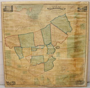
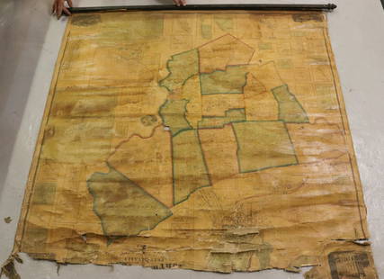
Sold2022MAP OF NORTHAMPTON COUNTY, PA 1860LINEN BACKED MAP MOUNTED ON BACKBOARD UNDER PLEXIGLASS (NO FRAMEWORK). SMITH,GALLUP & CO. PUBLISHERS, PHILADELPHIA, 1860. MEASURES 60" X 58". Terms & Conditions: Pick-up for this Auction will be WedneSee Sold Price
Sold2022MAP OF NORTHAMPTON COUNTY, PA 1860LINEN BACKED MAP. SMITH, GALLUP & CO. PUBLISHERS, PHILADELPHIA, 1860. MEASURES 56" X 57" Terms & Conditions: Pick-up for this Auction will be Wednesday August 3rd and Thursday August 4th from 9:00am tSee Sold Price
Sold20241920's World Map and Rural Life and Farm Stock Map of NY1920's World map with world leaders, rural life and farm stock journal map of New YorkSee Sold Price
Sold2017Breou's Farm Maps of Chester County, Pennsylvania, WHBreou's Farm Maps of Chester County, Pennsylvania, WH Kirk, Philadelphia, 1883, unbound at spine, edges good-very good, full, boards fair-good, but may not contain all platesSee Sold Price
Sold2017Breou's Farm Maps of Chester County, Pennsylvania, WHBreou's Farm Maps of Chester County, Pennsylvania, WH Kirk, Philadelphia, 1883, taped at spine, edges good-very good, full, boards fair-good, but may not contain all platesSee Sold Price
Sold2017Breou's Farm Maps of Chester County, Pennsylvania, WHBreou's Farm Maps of Chester County, Pennsylvania, WH Kirk, Philadelphia, 1883, intact spine, edges good-very good, full, boards fair-good, but may not contain all platesSee Sold Price
Sold2017Breou's Farm Maps of Chester County, Pennsylvania, WHBreou's Farm Maps of Chester County, Pennsylvania, WH Kirk, Philadelphia, 1883, unbound at spine, edges tattered, losses to boards, full, but may not contain all platesSee Sold Price
Sold2017150 plus loose plates from Breou's Farm Maps of Chester150 plus loose plates from Breou's Farm Maps of Chester County, Pennsylvania, WH Kirk, Philadelphia, 1883, with a bindingSee Sold Price
Sold2021EARLY BETHLEHEM AND NORTHAMPTON COUNTY BOOK LOTINCLUDING VARIOUS BOOKS ON THE LEHIGH VALLEY, BETHLEHEM, AND NORTHAMPTON COUNTY TERMS: THIS SALE WILL BE ONLINE ONLY. PICK-UP WILL BE ON-SITE AT 14 CHURCH ST. BETHLEHEM, PA 18018 - APPOINTMENTS WILL BSee Sold Price
Sold2022Pennsylvania Painted Blanket ChestA Pennsylvania paint decorated blanket chest, Northampton or Lehigh County, circa 1790-1810, the strap hinged rectangular top with applied molded edge enclosing a dovetail-constructed box with a leftSee Sold Price
Sold20214 Books on PennsylvaniaIncludes The Farm Journal Illustrated Directory of Adams County Pennsylvania 1915-1920, The Pennsylvania Barn 2nd edition (signed), Thaddeus Stevens in Gettysburg: The Making of an Abolitionist (signeSee Sold Price
Sold20211845 History of Northampton, etc. CountiesFull title: History of Northampton, Lehigh, Monroe, Carbon, and Schuylkill Counties. Published and sold by G. Hills, Lancaster; printed by Hickok and Cantine, Harrisburg. Losses to binding. Front andSee Sold Price
Sold202218th C. WAYNE COUNTY PA DRAWN PROPERTY DRAFT MAPLAND SURVEYED DECEMBER OF 1784, SIGNED BY GEORGE PALMER OF NORTHAMPTON COUNTY, MOUNTED ON CANVASSee Sold Price
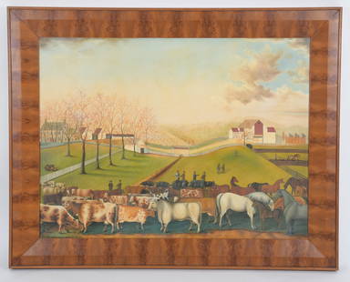
Sold2023David Guilmet, Bucks County Folk Art LandscapeDavid Guilmet (American, 20th Century) An Indian summer view of the Farm & Stock of James C. Cornell of Northampton, Bucks County Pennsylvania. That took the Premium in the Agricultural Society, OSee Sold Price
Sold2022Hamilton Farm James Cox Brady ResidenceHunterdon Somerset & Morris Counties Map is approx 33 1/2" x 43 1/2"See Sold Price
Sold20181833 Census Map of the Counties of Leicester,Reserve Reduced! Title/Content of Map:1833 Census Map of the Counties of Leicester, Northampton, Ruthland, Warwick and Worcester -- Counties of Leicester, Northampton, Ruthland, Warwick and WorcesterSee Sold Price
Sold20201940 Rock County Wisconsin Farm Plat Book w/ Maps1940 Rock County Wisconsin Farm Plat Book w/ Maps 4lbs 18 x 16 x 1/2 Shipping in continental US $25.00 If shipping is $0 then buyer arranges pick up or shipping. Please ask any questions before biddinSee Sold Price
Sold2018MAP OF NEW JERSEY COUNTIESOf Hamilton Farm, Hunterton, Morris, and Somerset Counties. Frame size: 27"h x 22 1/2"wSee Sold Price
Sold2022KENT – LYDD – MANUSCRIPT ESTATE MAP 'A Map of a Farm lying in the Parish of Lydd in ...KENT – MANUSCRIPT ESTATE PLAN 'A Map of a Farm lying in the Parish of Lydd in the County of Kent Belonging to the Reverd. Mr Richard Monins 1774.', manuscript map by Henry Maxted & Isaac Terry,See Sold Price
Sold2022FRAMED MAP OF THE HAMILTON FARM, NEW JERSEY"Map of Hamilton Farm and Adjacent Properties, Bridle Paths, Roads, etc. in Hunterdon, Morris & Somerset Counties, in the State of New Jersey" by F.S. Tainter, March, 1935. Details include Somerset HiSee Sold Price
Sold2022Watercolor and Calligraphy Land Draft MapDraft map showing a farm owned or possibly being conveyed to a daughter of Henry Lewis in Dickinson Township, Cumberland County circa 1800 and signed by William Line or Lind. A very fine watercolor shSee Sold Price
Sold2020New Tracks In North America 1stNew Tracks In North America A Journal of Travel and Adventure Engraved in the Survey for a Southern Railroad to the Pacific Ocean During 1867 - 1868. Two volume set. NumerSee Sold Price
Sold2018Guadalcanal DiaryGuadalcanal Diary Map End papers. Penquin Special. Photo covers. Author: Richard Tregaskis Dated: 1944 Pages 217 Publisher: InfantrySee Sold Price
Sold2021Pennsylvania 19th Century Maps (2)The first is a Pennsylvania, New Jersey, and Delaware folding map dated 1848 published by S. Augustus Mitchell with colored counties. It has close ups of Pittsburg, Lehigh & Schuylkill, Philadelphia,See Sold Price
Featured6 days LeftJasper521878 Mitchell Map of Virginia and West Virginia [verso] New Jersey, Maryland and Delaware -- CountyUS$45
6 days LeftJasper521879 Powell Map of Utah -- Map of Utah Territory Representing the Extent of the Irrigable, TimberUS$120
Jun 23Schilb Antiquarian Rare Books1848 Emory Military Reconnaissance 1ed California MAP Indians Texas New MexicoUS$1
6 days LeftJasper521892 Cowles Civil War Map of Battles in Gettysburg, Virginia, W Virginia and Maryland -- Sketch ofUS$55
6 days LeftJasper521878 Mitchell Map of Washington, Oregon, Idaho, much of Montana [verso] Territory of IdahoUS$55
6 days LeftJasper521866 Johnson Map of Wisconsin and Michigan -- Johnson's Michigan and WisconsinUS$55
Jun 23Treasure Quest AuctionsPr. Child's Ulster County, NY 1871-72 Gazetteer & Business DirectoriesUS$50


![1878 Mitchell Map of Virginia and West Virginia [verso] New Jersey, Maryland and Delaware -- County (1 of 2)](https://p1.liveauctioneers.com/5584/329422/177662152_1_x.jpg?height=282&quality=70&version=1715717898)


![1878 Mitchell Map of Washington, Oregon, Idaho, much of Montana [verso] Territory of Idaho (1 of 2)](https://p1.liveauctioneers.com/5584/329422/177662232_1_x.jpg?height=282&quality=70&version=1715717898)


![Untitled. Midwest. [Map Issued With the Official Inter-State Railway Guide] (1 of 1)](https://p1.liveauctioneers.com/5584/329422/177662238_1_x.jpg?height=282&quality=70&version=1715717898)

