Sold2022Four Antique Maps of the United States: Thomas & Andrews, Boston, "A Map of the United States ofFour Antique Maps of the United States: Thomas & Andrews, Boston, "A Map of the United States of America," A. Doolittle, N. Haven; Joh. George Schreibern, "America" printed in LeipSee Sold Price
Sold20201835 PRINTING OF A 1722 BOSTON MAP BY JOHN BONNERTHE TOWN OF BOSTON IN NEW ENGLAND BY CAP'T JOHN BONNER, 1722 (THIS IS A REPRINT FROM 1835) ; 19 3/4" X 25 3/4" IMAGE UNDER GLASS IN WOOD FRAME; SOME STAINING AND SEVERAL TEARS , MOSTLY ON LEFT SIDESee Sold Price
Sold20183 Maps incl: Map Of Boston And Adjacent Cities.[World/ Massachusetts/Europe] 3 Maps. ++ A New Map Of The World On The Globular Projection. Phila: Thomas, Cowperthwait & Co., (1850). Hemispheres. Outer edge of overall border: 9 1/2 x 14 1/8 in. TonSee Sold Price
Sold2018Railroad Books B&M Climax NYCA group of 5 train books. Three are Boston & Maine related: (1) The Central Mass - original with good photos, not the crappy reprint, has map in pocket (2) High Green & the Bark Peelers - A railroaderSee Sold Price
Sold2017Thomas & Andrews: Antique Map of Massachusetts, 1796Map: Massachusetts Date: 1796 Medium: Original copperplate engraving From Morse's Universal Geography by Thomas & Andrews, Boston, 1796 Dimensions: 15" x 12.5" Unframed. Please note that this lot hasSee Sold Price
Sold2018Antique colonial map by Thomas Jefferys after NicolasAntique colonial map by Thomas Jefferys after Nicolas Bellin, mid-18th-century map stretching from Boston north to Labrador. The fishing banks off Nova Scotia and Newfoundland are marked, with soundinSee Sold Price
Sold20174 TN Maps, Bradford, 1835, 1838, & 18411st item: "Tennessee" Map, by Thomas G. Bradford, engraved by George W. Boynton, published by William D. Ticknor, Boston, 1835. From "A Comprehensive Atlas, Geographical, Historical & Commercial" by TSee Sold Price
Sold2020[BOSTON]. A group of 8 maps and directories for Boston[BOSTON]. A group of 8 maps and directories for Boston and Cambridge, comprising: DICKINSON, S. N. The Boston Almanac for the Year 1844. Boston: Thomas Groom & Co. -- DICKINSON. The Boston AlmanaSee Sold Price
Sold20163 19th cent. Maps, 1 of TN and KY, 2 of TN1st item: "Tennessee & Kentucky" Map, drawn by Thomas G. Bradford, engraved by George W. Boynton, published by William D. Ticknor, Boston, 1835. From "A Comprehensive Atlas. Geographical, Historical,See Sold Price
Sold2020EuropePublication Date: 8/23/1914 Title: Europe Cartographer: POATES, L. L. ENGR. CO. Publisher: BOSTON SUNDAY POST Height: 13.1 Width: 14.5 Unusual full color reprint of a Poates map on the front page of tSee Sold Price
Sold20211802 Morse's Universal Geography Vol 1-2 Morse, FMorse, Jedidiah. 1801-1802 Morse’s Universal Geography Part I and II. Part I is a Fourth Edition and is corrected and enlarged with 28 illustrated maps and charts. Printed at Boston by Isiah ThomasSee Sold Price
Sold2018Jedidiah Morse. Geography Made Easy. Boston: for ThomasJedidiah Morse. Geography Made Easy. Boston: for Thomas & Andrews, 1806. 8vo. 432 p. Folding map frontis of the world, and folding map of North America. Both maps VG. Full leather. // Morse. GeographySee Sold Price
2021Bradford's Map of Texas 1835/36"Bradford's Map of Texas, 1st Separate Map of Texas to Appear in an Atlas" by Thomas G. Bradford, copper engraving with hand-colored outlines, published Boston, 1835/1836, together with accompanying aSee Sold Price
Sold2021Thomas Jefferson. Notes on Virginia. 1802.[Virginia] Thomas Jefferson. Notes on the State of Virginia. H. Sprague, Boston, 1802. Ninth American Edition. 8vo. 368 pages, folding map, 1 plate. Contemporary leather, gilt. Condition Very good. FoSee Sold Price
Sold2016Map of Maryland, Delaware and Washington, DC, 1796Original engraving from Morse’s Universal Geography published by Thomas & Andrews, Boston, 1796. Dimensions: 12 3/4” x 15” No Reserve This item ships from Ocean View, DE.See Sold Price
Sold2019After Thomas Jefferson "A Map of the Country betweenAfter Thomas Jefferson "A Map of the Country between Albemarle Sound and Lake Erie," 1900, a reprint of the 1787 original, H.- 27 in., W.- 25 1/4 in.See Sold Price
Sold2024C. 1793 ENOCH GRIDLEY WORLD MAP ENGRAVINGCopper plate engraving by Enoch Gridley. Boston, CA, 1793. Published by Isdiah Thomas and Ebenezer Andrews. Dimensions: H 8.5" x W 12.5". Condition: Foxing, wear on the creases. Edges are curled.See Sold Price
Sold2020BostonTitle/Content of Map: Boston Date Printed: 1901 Material/Medium: paper Size: approx. 10.5x13.5 inches The National Standard Family & Business Atlas of the World. Published by Thompson & Thomas (Fort DSee Sold Price
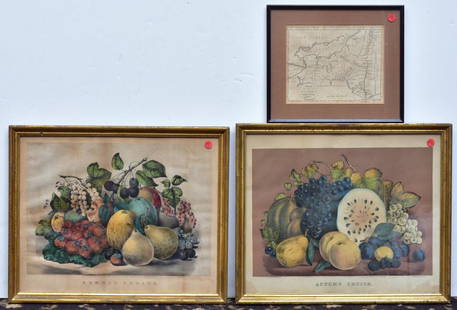
Sold2020Two Currier & Ives PrintsAutumn Fruits and Summer Fruits each 15 1/2" x 19" stone lithographs and a Map of the State of New York by J. Denison, published by Thomas & Andrews, Boston, 1796See Sold Price
Sold2017Chart of the World On Mercators Projection, 1796Map: Chart of the World On Mercators Projection Maker: Thomas & Andrews, Morse/Doolittle (Sculp) Publisher: Boston, 1796 Size: Quarto - 7.30 H x 10.00 W Inches Small map of the world. Shows LouisianaSee Sold Price
Sold2022OLIVER JOHNSTON (1952-1990) Original colored sketches for Silence=DeathOLIVER JOHNSTON (1952-1990) Original colored sketches for Silence=Death Color crayon on vellum. 349x280 mm; 13x11 inches. Circa 1986.The sketches, four on a single sheet, include pink triangles on ligSee Sold Price
Sold2022America.- Missouri prospectus.- Moore (Thomas) Missouri City, lithographed plan, [c. 1836].America.- Missouri prospectus.- Moore (Thomas, Boston based lithographer and publisher, active 1830s) Missouri City, lithographed city plan of the proposed new town that was planned to prosper from thSee Sold Price
Sold2022A FEDERAL MAHOGANY INLAID CHESTAttributed to the workshop of John and Thomas Seymour, Boston, Ma...A FEDERAL MAHOGANY INLAID CHEST Attributed to the workshop of John and Thomas Seymour, Boston, Massachusetts, circa 1800-1810 height 42 3/4in (108.6cm); width 42in (106.7cm); depth 21in (53.3cm) FootnSee Sold Price
May 09Hunt and Peck Estate Services, Inc.1794 Laurie & Whittle after Thomas Jefferys Map Of The United States Of AmericaUS$340(1 bid)
3 hrs LeftMynt AuctionsFrank Thomas 2021 Topps Tier One IA-FTA Bronze Ink Auto 16/25 White Sox 76139US$10
5 days LeftMerrill's Auctioneers and AppraisersDavid Lewis (AM 19th c) portrait of Sarah Merry LewisUS$100


![3 Maps incl: Map Of Boston And Adjacent Cities.: [World/ Massachusetts/Europe] 3 Maps. ++ A New Map Of The World On The Globular Projection. Phila: Thomas, Cowperthwait & Co., (1850). Hemispheres. Outer edge of overall border: 9 1/2 x 14 1/8 in. Ton](https://p1.liveauctioneers.com/179/117971/60557739_1_x.jpg?height=310&quality=70&version=1520636872)


![[BOSTON]. A group of 8 maps and directories for Boston: [BOSTON]. A group of 8 maps and directories for Boston and Cambridge, comprising: DICKINSON, S. N. The Boston Almanac for the Year 1844. Boston: Thomas Groom & Co. -- DICKINSON. The Boston Almana](https://p1.liveauctioneers.com/197/168691/85058461_1_x.jpg?height=310&quality=70&version=1589391499)


![Thomas Jefferson. Notes on Virginia. 1802.: [Virginia] Thomas Jefferson. Notes on the State of Virginia. H. Sprague, Boston, 1802. Ninth American Edition. 8vo. 368 pages, folding map, 1 plate. Contemporary leather, gilt. Condition Very good. Fo](https://p1.liveauctioneers.com/179/209052/106367330_1_x.jpg?height=310&quality=70&version=1624651037)


![America.- Missouri prospectus.- Moore (Thomas) Missouri City, lithographed plan, [c. 1836].: America.- Missouri prospectus.- Moore (Thomas, Boston based lithographer and publisher, active 1830s) Missouri City, lithographed city plan of the proposed new town that was planned to prosper from th](https://p1.liveauctioneers.com/5458/257239/133765062_1_x.jpg?height=310&quality=70&version=1659622051)


