Sold20232 Framed Maps of Canada & U.S.Group of two framed maps depicting Canada and the United States. One map depicting the East Coast of the United States as well as southeastern Canada. One map depicting Lake Superior and south-centralSee Sold Price
Sold2024Two Vintage Framed Maps of AmericaTwo vintage 20th century maps, nicely framed and matted, including a map of the United States together with a map of Florida and the Gulf of Mexico. Provenance: Phyllis Lucas Gallery, NYC. [Larger fraSee Sold Price
Sold2018D.F.R. Robinson Map of the United States.D.F.R. Robinson Map of the United States. Connecticut, 1828. Engraved map in two colors. Framed and matted, 19 x 24" overall. Mild brownish discoloration along central vertical fold, otherwise fine.See Sold Price
Sold2021Two WWII Illustrated Campaign Maps FramedOperations of First United States Army in Europe from June 6, 1944 to May 9, 1945, surrounded by division logos. Measures 20"H x 19.5"W framed, 17.75"H x 18"W unframed. First U.S. Army & Fifth USSR CaSee Sold Price
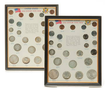
Sold2021TWO FRAMED UNITED STATES 20TH CENTURY TYPE COINSTwo framed 20th century type coin groups. Both contain the different coinage minted in the United States during the 20th century. Includes four silver dollars, eight silver half dollars, six silver quSee Sold Price
Sold20241825 Framed United States MapApprx 23 1/2" x 27 1/2". If shipping is needed, get a quote thru UPS Store 5528 before bidding.See Sold Price
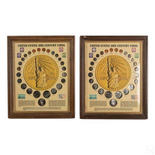
Sold202120th Century American Coins and Stamps CollectionsTwo framed displays of United States 20th Century coin with stamp. Each includes 25 coins and six stamps ranging from a 1899 Barber coin, to a 1986 Liberty coin. Bears Kennedy MDSE Center registered sSee Sold Price
Sold2022Map of United States, JH Colton, ca 1849A framed map of the United States, Map of the United States of America, The British Provinces, Mexico, the West Indies and Central America with part of New Granada and Venezuela by JH Colton, ca 1849,See Sold Price
SoldTwo Framed 'New Goods' Broadsides, mid-Atlantic United States, 1853-60. One sheet printed in bl...Two Framed 'New Goods' Broadsides, mid-Atlantic United States, 1853-60. One sheet printed in black ink, advertising 'New Goods for the Fall Trade of 1860 at the Store of W.H. Parsons in Pine Valley' dSee Sold Price
Sold2023Salvador Dali DISCOVERY OF AMERICA w/ Two United States Columbian Half DollarsSalvador Dali (Spain, 1904-1989). DISCOVERY OF AMERICA Lithograph by Dali, custom framed with two United States Columbian Half Dollars. Diego Colon Edition. Pencil signed, Dali, edition numbered in peSee Sold Price
Sold201718thc Map: United States of America, Wilkes, 1797Framed antique map, United States of America, Published London 1797 by J. Wilkes. Engraved by Neele, 352 Strand, London. Hand colored, the map shows the United States in the Decade after the AmericanSee Sold Price
Sold2018MAPS: (2) U.S. Regional 1846 Meyer's AtlasMAPS: (2) U.S. Regional 1846 Meyer's Atlas, Pair of United States regional maps. Framed, sizes given are area inside mat followed by overall framed size. Both from Meyer's Universal Atlas and marked SSee Sold Price
Sold2022Two framed American prints: Gordon Hope Grant (UnitedTwo framed American prints: Gordon Hope Grant (United States 1875-1962), "Fishing Boats, Gloucester", lithograph, c. 1935, Ed: 250, as published by AAA, signed with pencil lower right, printed with blSee Sold Price
Sold2022Set of Framed 19th C. Relief Maps (3)Printed in Chicago, 1893, set includes a framed relief map of the United States, a relief map of Europe, and a relief map of the world, 27" x 37 1/2" sight, 34" x 47 1/2" framed.See Sold Price
Sold2024Two Maps of the United States by William Faden (London, 1785 and 1796)Two Maps of the United States by William Faden (London, 1785 and 1796) Two hand-colored maps engraved by William Faden (British, 1749-1836), London, 1785 and 1796. Titled "The United States of North ASee Sold Price
Sold20182 Framed antique maps2 Framed antique maps, probably from an old atlas, British America & The United States, map drawn & engraved by J. Rapkin, illustrations by H. Warren & illustrations by R. Wallis, Maps are 10" x 13",See Sold Price
Sold2017Two framed hand colored 19th century lithographsTwo framed hand colored 19th century lithographs including “James Madison / 4th President of the United States” by N. Currier – sight size 9.75” x 13.75” – mounted in period ogee frame - sSee Sold Price
Sold2020Two Framed Ornithological Plates from Thomas GentryThomas Gentry, Birds of The United States, 1882, Mourning Dove and White Bellied Nuthatch, chromolithographs, matted in hand drawn English mat and framed. 11 x 7.5 in. image 21 x 17 in. as framedSee Sold Price
Sold2019Two Antique MapsTwo Antique Maps. Map of United States and Texas, dated 1839 by Daniel Burgess and a Map of Mexico Central America and the West Indies, dated 1867 by S Augustus Mitchell.See Sold Price
Sold2018Small Robert Morden antique hand coloured map ofSmall Robert Morden antique hand coloured map of Middlesex, together with a set of six framed maps of the United StatesSee Sold Price
Sold2017UNITED STATES 1860 MAP, J.W. LOWRY, TERRITORIESFramed map of "The United States of North America (General Map)", c. 1860, "drawn and engraved by" J.W. Lowry (Joseph Wilson Lowry, British, 1803-1879), published by Blackie & Son, Glasgow, EdinburghSee Sold Price
Sold2017MAP OF THE UNITED STATES, C. 1861Framed map of the United States, 1861, showing 32 named states with western areas mostly in irregular shapes, penciled date of 1861, sight: 3.5/8"h, 5.75"w, overall: 10"h, 12'w, 1.5lbs Start Price: $8See Sold Price
Sold2022Wonderful 1872 map of Alaska with orig. hand coloringVery nice and uncommon two-page map titled “Northwestern America showing the Territory ceded by Russia to the United States.” Map was published by H. H. Lloyd in 1872, just five years afteSee Sold Price
1 day LeftRapid Estate Liquidators and Auction GalleryAntique Revolutionary War Hardcovers By William James 2 VolumesUS$2,000