Sold2023Venezuela coast. Aruba Bonaire Curacao. ADMIRALTY sea chart 1894 (1955) mapSouth America - North Coast - Tortuga to Cabo la Vela // Catia de la Mar' by From the latest Documents in the Hydrographic Office with additions and corrections from United States and Netherlands GovtSee Sold Price
Sold2023Trinidad Island. Eastern Part. West Indies. ADMIRALTY sea chart 1869 (1950) mapTrinidad Island - Eastern Portion' by Bocas Del Dragon to Icacos point from the surveys by Commr. Alun Jones, R.N., and the Officers of H.M. Surveying Ship "Challenger" 1936. Eastern portion of Gulf oSee Sold Price
Sold2016•George Leech (1894-1966) Pembrokeshire Coast, original•George Leech (1894-1966) Pembrokeshire Coast, original artwork for the British Railways Western Region poster, signed oil on canvas c.1950 - 101 x 126 cm Artist's Manresa Road Chelsea studio labelSee Sold Price
Sold2021Antique Coast Survey Map of the Atchafalaya BayAntique Coast Survey Map of the Atchafalaya Bay , "Preliminary Chart of Atchafalaya Bay Louisiana... A.D. Bache, Superintendant", 1858, lithograph, with later hand-coloring, sight 24 1/2 in. x 31 1/4See Sold Price
Sold2021Boscoe HOLDER (1921-2007) Trinidad & TobagoBoscoe Holder, portrait of a young man, oil on canvas, 19 x 14 inches. Signed and dated '1969' upper right corner.See Sold Price
Sold2024Brass Chart Map Glass Magnifying Desk Lens Magnifier w BoxGlass is 1 7/8" Wide x 2" High,.. adjustable to 2 1/2" box is 2 3/4" x 2 3/4" x 2 3/4" Nice reproduction of an antique magnifying lens. Nice heavy quality thick glass. This piece slides along the surfSee Sold Price
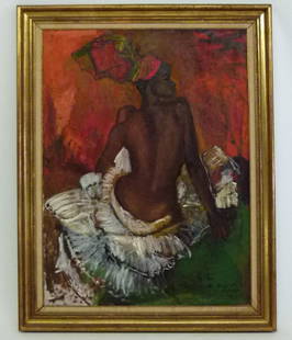
Sold2018O/MASONITE "WEST INDIAN GIRL" SIGNED BOSCOE HOLDENO/MASONITE "WEST INDIAN GIRL" SIGNED BOSCOE HOLDEN (TRINIDAD-TOBAGO 1921-2007) 48" X 36"See Sold Price
Sold2022LARGE ARCHITECTS PRINT / MAP / CHART CABINETFantastic very large Architectural draftsman/chart/map/print flat file - George III-Style mahogany with satinwood inlay, inset tooled leather top. 8 Drawer over 4 drawer. from the Audubon Gallery, KinSee Sold Price
Sold2021Album different bank notes various countries S-TThe album contains various banknotes from Switzerland, Syria, Tahiti, Sao Tome e Principe, Tanzania, Thai, Ultramarino, Tonga, Trinidad & Tobago. In good condition, mostly uncirculated. Switzerland: 1See Sold Price
Sold2021M.J. Cazabon 19th C. Watercolor Landscape, TrinidadMichel Cazabon (France, Trinidad and Tobago, 1813-1888) Caribbean watercolor landscape depicting the figures of an adult and child standing at the edge of a body of water, with trees and hut in backgrSee Sold Price
Sold2022Boscoe (Arthur Aldwyn) Holder (1921 - 2007)Boscoe (Arthur Aldwyn) Holder (Trinidad and Tobago, England, 1921 - 2007) Oil on board painting of a reclining woman. Signed and dated lower right. Sight Size: 20 x 36 in. Overall Framed Size: 24 x 40See Sold Price
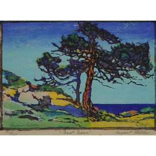
Sold2021Margaret Jordan Patterson, Coast Cedars, color woodcutMargaret Jordan Patterson (American, 1867-1950) Coast Cedars color woodcut signed in pencil lower right margin and lower left in print, titled lower center edition of 100 7 1/8" x 10 1/4"See Sold Price
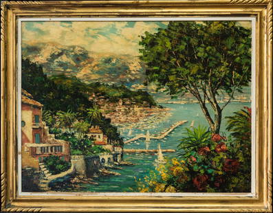
Sold2017Painting, Georgi LapchineGeorgi Alexandrovich Lapchine (Russian, 1885-1950), Amalfi Coast Harbor Scene with Fishing Boat and Figures, oil on canvas, signed lower right, canvas: 35"h x 47"w, overall (with frame): 42.5"h x 54.5See Sold Price
Sold202370304: A Marshall Islands Navigation Map Micronesia, 1A Marshall Islands Navigation Map Micronesia, 19th century Constructed of coconut palm leaf midribs and shells. Such maps or charts were for navigating specific atolls and islands in MicrSee Sold Price
Sold2023Irma Stern (1894 - 1966) South Africa, Europe Artist Oil On BoardSubject: Modernist Medium: Oil On Board Size: 12 x 18 inches Frame: 17 x 23 inches Condition: Great overall condition Signature: Lower left, dated 1950 Irma Stern (1894 - 1966) Irma Stern (1894 - 1966See Sold Price
Sold2023Arthur Hill Gilbert (1894-1970), Sand dunes near the coast, Oil on canvasboard, 9" H x 12" WArthur Hill Gilbert(1894-1970)Sand dunes near the coastOil on canvasboardSigned lower left: Arthur Hill Gilbert9" H x 12" W Exhibited: Santa Clara, CA, De Saisset Art Gallery, "CalifornSee Sold Price
Sold2023Amedee Julien Marcel Clement ( French 1873-c1950) OilAmedee Julien Marcel Clement ( France 1873 - c. 1950 ) " Remous Du Coist " Oil on Hard Board Singed Lower Right and Signed Again on Upper Right Back Framed Seascape Landscape with Ship or Sailboat atSee Sold Price
Sold2022Lyon & Healy Harp Style 15 Semi GrandLyon & Healy Harp Style 15 Semi Grand Serial # 3801 Natural finish with gold accents 71" tall Gold Medals and Highest Honors Chicago 1893 Antwert 1894 London 1909 Leipzig 1909 Mecio City 1921 Comes wiSee Sold Price
Sold2020Des Barres Map of NY Harbor*** START PRICE IS THE RESERVE *** [America] DES BARRES, Joseph Frederick Wallet (1729-1824). A Chart of New York Harbour with the Soundings Views of Land Marks and Nautical directions for the Use ofSee Sold Price
Sold2017De Wit Portolan Sea Chart of EuropeTotius Europae Victoria... Frederic De Wit (1630-1706). Engraved map with original hand color. Amsterdam, 1675. 20 x 35 1/2 inches sheet, 27 1/2 x 43 inches framed. “The most striking and decorativeSee Sold Price
Sold2020Old Northwest Coast Raven Totem Pole 6'5''Old Northwest Coast Raven Totem Pole 6'5''. A carved and painted cedar totem pole with raven, salmon, bear and seal. Unsigned. Some scattered surface wear to paint. Circa 1950's or older. Total size 7See Sold Price
Sold2018"Coast Scene" Original Oil Albert Ernest Backus"Coast Scene" Original Oil By Florida Artist Albert Ernest Backus 1906-1990 Signed Lower Right Oil on Canvas Painting Size: 30 By 40 inches. Frame Size: 36 by 46 inches. Created in 1950's CONDITION GoSee Sold Price
Sold2022(PICTORIAL MAPS.) John Diakoff; G. Primakoff; and P. Sergeeff. Map of China.(PICTORIAL MAPS.) John Diakoff; G. Primakoff; and P. Sergeeff. Map of China. Enormous chromolithographed map of China with profuse pictorial illustration, inset charts, reference tables, and scenic viSee Sold Price
Sold2022Alvar Aalto (1898-1976) & Aino Aalto (1894-1949) Set of ten chairs Model n°615 and a diningAlvar Aalto (1898-1976) & Aino Aalto (1894-1949)Set of ten chairs Model n°615 and a dining tableTeak, birch and rattanEdited by ArtekModel created in the 1950'sTable : H 70 × L 255 × PSee Sold Price
14 hrs LeftJasper52Hawaiian–Emperor seamount chain Midway-Kauai ADMIRALTY chart 1950 (1955) mapUS$140
May 16Zikorn Arts & History ObjectsCentral America West Coast 1855 British Admiralty Nautical ChartUS$100(1 bid)
May 16Zikorn Arts & History ObjectsEntrance to Baltic Great & Little Belt 1852 British Admiralty MapUS$100
Featured14 hrs LeftJasper52NW Coast of America & NE Coast of Asia… ROBERTS / DELAROCHETTE. Pacific 1794 mapUS$700(1 bid)
May 16Zikorn Arts & History ObjectsWest Indies, Providence, Windward, Cuba 1834 British Admiralty MapUS$100(1 bid)
14 hrs LeftJasper52Côte Nord-Est de la Nouvelle Calédonie…'. ROUBET. New Caledonia 1849 old mapUS$180
May 14Fleischer's Auctions1755 Map Partie de l'Amerique Septentrionale, qui comprend Le Cours de L'Ohio...US$200(3 bids)
May 12Hoch LTD.Jazz West Coast, William Claxton (American, 1927-2008) A Portfolio Of Photographs, First Edition,US$80(1 bid)
May 14Fleischer's AuctionsLincoln's Funeral Cortège Book by Custodian of Lincoln's TombUS$150(2 bids)


![Des Barres Map of NY Harbor: *** START PRICE IS THE RESERVE *** [America] DES BARRES, Joseph Frederick Wallet (1729-1824). A Chart of New York Harbour with the Soundings Views of Land Marks and Nautical directions for the Use of](https://p1.liveauctioneers.com/1968/163248/82424572_1_x.jpg?height=310&quality=70&version=1583340284)


![[WWI] P.T. Sherman's WWI Service Record & Books (1 of 8)](https://p1.liveauctioneers.com/7226/322253/173251586_1_x.jpg?height=282&quality=70&version=1710004847)


