Sold2023c 1706 Pieter Van Der Aa North + South America Map as 1st Discovered by ColumbusHistoric Maps 1706 North & South America Map Discovered by Columbus First Voyage Published by Dutch Map Pieter Van Der Aa (1659-1733) c. 1706-1708, Original Map of North & South America (translated) tSee Sold Price
Sold2023Sharp Rope Design Silver RingSharp Rope Design Silver Ring Ring is tested silver, is a size 6 and weighs a substantial 11.40 grams. Ring rides north-south on finger approx 1 1/4î - edges have a rope design and no hallmarks aSee Sold Price
Sold2021North And South Carolina Postcard CollectionNorth Carolina (186) and South Carolina (54) assorted postcards.See Sold Price
Sold2021Scarce 1849 map of AmericaScarce 1849 map of North America and South America by Joseph Meyer as found in the Meyer’s Zeitungs-Atlas of 1850. Shows all of North America as well as South America from the Arctic to Cape Horn. ISee Sold Price
Sold20221765 Atlas Map of North + South AMERICA, ExpillyHistoric Maps 1765 Atlas Map of North and South AMERICA by Expilly 1765 Copper Engraved Atlas Map of North and South AMERICA titled, "AMERIQUE Septentrionale et Meridionale," from Le Geographe ManuelSee Sold Price
Sold2023C. 1900-1930 Alaskan Historic Postcard CollectionThis lot contains a collection of over 60 antique postcards, all related to Alaska. The topics of the cards vary from landscape, fishing, Tlingit culture, and more. The postcards originate from the eaSee Sold Price
Sold2023Postcards 11 Real Photo Illinois TownsIncludes North Aurora, Norwood park, nokomis, Normal, north HendersonSee Sold Price
Sold202125 Scarce, Early 20th Century Postcards: 3 Rare (T.)25 Scarce, Early 20th Century Postcards: 3 Rare (T.) Roosevelt Bears Cards, 12 Cards by Howard Christy, 10 by Harrison Fisher. Fine collection of historic postcards, a snapshot of very early 20th CentSee Sold Price
Sold2017Johnson’s Civil War era map of North & South CarolinaHistoric map shows the Carolinas in great detail shortly following the outbreak of the Civil War. States hand-colored at the time of publishing with color coding according to county. Inset map depictsSee Sold Price
Sold2024Postcards - 11 Railroad Depots and TrainsIncludes CM and St. P in Hartford Wisconsin, M K and T in Parsons Kansas, D and H in Ballston Spa North Dakota, and more.See Sold Price
Sold2024Gold in Quartz in Yellow Gold RingGold in Quartz in Yellow Gold RingAttractive ring runs 15mm north-south on the finger and holds a plaque of gold in black quartz which measures approx 13.3 x 11.1. Ring is marked and tested 10k, is aSee Sold Price
Sold2022Midwestern States Token Collection [146493]Large lot of over 60 tokens from several Midwestern states. Iowa (6); Missouri (4); Nebraska (3); North Dakota (6); South Dakota (11); Kansas (20); Ohio (8); Indiana (2); Wisconsin (3); Minnesota (3);See Sold Price
Sold2017Map of the Seaboard Air Line, 1895Map of the Seaboard Air Line and its principle connections north, south, east and west, published in 1895 by Rand, McNally & Co. 10 x 11.875 inches. Hard to find this map in such an early version. ThiSee Sold Price
Sold2022Group of Vintage postcardsGroup of approximately 106 Vintage postcards including Colorado, Nebraska, South Dakota, North Dakota, Oklahoma, Wyoming,, and Mountain. CONDITION: commensurate with age, some with corner wear, some uSee Sold Price
Sold2018Group of Pocket Books and PostcardsGroup of Pocket Books and Postcards. Includes: 4 Edward Curtis Photography Books and 11 postcards; Sacred Symbols Native Americans; and North American Indian Arts. We ship most items in-house with theSee Sold Price
Sold2022A MAP OF VIRGINIA, NORTH AND SOUTH CAROLINA, GEORGIA, MARYLAND, WITH PART OF NEW JERSEY, & C, 1755.A MAP OF VIRGINIA, NORTH AND SOUTH CAROLINA, GEORGIA, MARYLAND, WITH PART OF NEW JERSEY, & C, 1755. - 9 x 11 in; frame: 12.5 x 14.5 in.See Sold Price
Sold2021Antique John Cary maps of North and South WalesAntique John Cary maps of North and South Wales. Sight size of Maps 8 3/4"h x 11"w Frame 18"h x 32"wSee Sold Price
Sold20181852 Philip Map of North and South America -- AmericaTitle/Content of Map: 1852 Philip Map of North and South America -- America Date: 1852, Liverpool Cartographer: G Philip Size: 11.9 x 9. 1 in. This is a handsome map of the Americas, offering detailsSee Sold Price
2018Philip: Antique Map of North and South America, 1852Title/Content of Map: 1852 Philip Map of North and South America -- America Date Printed: 1852, Liverpool Cartographer: G Philip Size: 11.9 x 9. 1 in. This is a handsome map of the Americas, offeringSee Sold Price
Sold2016S. Mitchell: North and South Carolina, 1871Map: North and South Carolina Cartographer: S Mitchell Publishing: Philadelphia, 1871 (marked 1850) Size: 11.3 x 14 inches A very nice map of the Carolinas, showing via color-coding the individual couSee Sold Price
Sold20211887 Mitchell Map of North and South Carolina -- NorthTitle: 1887 Mitchell Map of North and South Carolina -- North and South Carolina Cartographer: S Mitchell Year / Place: 1887, Philadelphia Map Dimension (in.): 11.3 X 14 in. A very nice map of the CarSee Sold Price
Sold20181867 Mitchell Map of North and South Carolina -- CountyTitle/Content of Map: 1867 Mitchell Map of North and South Carolina -- County Map of North and South Carolina Date: 1867, Philadelphia Cartographer: S Mitchell Size: 11.5 x 13.8 in. This is a handsomeSee Sold Price
Sold20211884 Mitchell Map of North and South Carolina -- NorthTitle: 1884 Mitchell Map of North and South Carolina -- North and South Carolina Cartographer: S Mitchell Year / Place: 1884, Philadelphia Map Dimension (in.): 11.3 X 14 in. This is a very nice map ofSee Sold Price
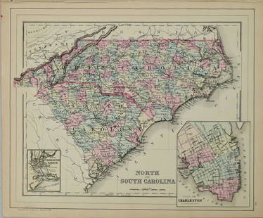
Sold2023North and South CarolinaPublication Date: 1887 Title: North and South Carolina Cartographer: BRADLEY, WILLIAM M. Publisher: WM. M. BRADLEY & BRO. Height: 11.5 Width: 14 Railroads shown and labelled. Inset plans of CharlestonSee Sold Price
1 day LeftBidhausBalenciaga 2way Tote XS Beige Silver Everyday 672793 Leather BALENCIAGA North South Handbag ShoulderUS$1
5 days LeftJasper52Map of the Wharf Accommodation of the Port of Sydney. Harbour Commissioners 1919US$1,300
4 days LeftJasper52Antique Yellow and Blue-Glazed Planter Pot from Guangdong Province with StandUS$1,400
Sep 28Trillium Antique Prints & Rare BooksVan der Aa - Map of Southern Atlantic Ocean: South America, part of North America, Europe, AfricaUS$75
Sep 29Estate Collection Auctioneer1975 Photography, Thomas Hart Benton Mural Oval Office Truman Historic Library.US$300
6 days LeftBrunk AuctionsRare North Carolina Federal Bellflower and Light Wood Inlaid Walnut SideboardUS$7,500
12 hrs LeftRichard Stedman Estate Services LLCWoven Vintage Basket Collection 11 Pc Lot Native American Possibly Additional World Cultures 4in ToUS$100


![Midwestern States Token Collection [146493]: Large lot of over 60 tokens from several Midwestern states. Iowa (6); Missouri (4); Nebraska (3); North Dakota (6); South Dakota (11); Kansas (20); Ohio (8); Indiana (2); Wisconsin (3); Minnesota (3);](https://p1.liveauctioneers.com/2699/243928/126481300_1_x.jpg?height=310&quality=70&version=1649517249)


![[CIVIL WAR] 1893 Libby War Museum Medal (1 of 3)](https://p1.liveauctioneers.com/7226/343781/186766812_1_x.jpg?height=282&quality=70&version=1726333566)


