Sold2023Two Framed Maps of the Carolinascomprising: Mentelle & Pierre-Gilles Chanlaire, engraved by Tardieu and Valet, Carte De La Caroline Meridionale et Septentrionale et de La Virginie, Paris, 1795, engraving on laid paper with hand coloSee Sold Price
Sold2023Vintage Framed Map of Paris1957 Blondel La Rougery Paris Map. Marked Plan De Paris A Vol D'Oiseau, Blondel La Rougery, Edit. Imp. 7, Rue Saint Lazare Paris 9e, Dressee Et Imprimee Par Blondel La Rougery, tous droits d reproductSee Sold Price
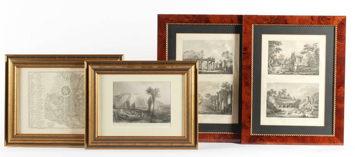
Sold2023Four Antique European EngravingsDescription: Each professionally framed, to include a 1796 map of Milan by J. J. De La Lande, a 19th century steel engraving after J.M.W. Turner of Ehrenbreitstein, and two plates depicting scenes ofSee Sold Price
Sold2021Jacques Nicolas Bellin MapsJacques Nicolas Bellin , "Plan de La Nouvelle Orleans" and "Carte des Embouchures du Mississipi", two hand-colored engraved maps, from Le Petit Atlas Maritime, 1764, 7 1/2 in. x 11 in., framed . ProveSee Sold Price
Sold2017Two 18th century engraved maps with hand coloringHind, Hindoostan, or India. Louis de la Rochette. Engraved map with hand color in part. London: W. Faden, c. 1790-1811. 31 x 23 inches framed. AND Africae in Tabula Geographica Delineatio. Adam FriedrSee Sold Price
Sold2017de la Rue: Antique Map of Jerusalem Patriarchate, 1730Map: Pinax Geographicus Patriarchatus Hierosolymitani Cartographer: Philippe de la Rue / Covens & Mortier Place & Date: Amsterdam / 1730 Size: 18" x 15 3/4" Condition: old color; overall age toning ThSee Sold Price
Sold2017de la Rue: Antique Map of Holy Land, 1730Map: Regnum Iudeorum in Filios Herodis Magni per Tatrarchias Divisum Cartographer: Philippe de la Rue / Covens & Mortier Place & Date: Amsterdam / 1730 Size: 18 1/2" x 15 1/2" Condition: old color; ovSee Sold Price
Sold2015Three Vintage Packs. Including two De La Rue decksThree Vintage Packs. Including two De La Rue decks (London, England, ca. 1870). VG-. One deck 32 card bezique deck with counter, the other 52 cards with numerals inked on corners of the number cards;See Sold Price
Sold2017Nicholas Sanson Antique Map of Brittany, FranceNicholas Sanson antique map "Le Canal de France ou La Manche". Framed map "La Bretagne Generalite de Nantes". Dimensions: Art: 21" H x 31" W; Frame: See Sold Price
Sold2022(ANATOLIA.) Pierre Mortier. Natolia. Asia Minor Auctore Phi. de la Rue.(ANATOLIA.) Pierre Mortier. Natolia. Asia Minor Auctore Phi. de la Rue. Large folio engraved map of Turkey, Cyprus and coastal Syria. 20¼x24¾ inches sheet size, wide margins, blank verso; orSee Sold Price
Sold2021MAP, Caucasus, de la RueCaucasus. Philippe de la Rue, Armenia Vetus in Quattuor Partes Distincta ad Tempora Iustiniani Imp., 1653 (dated). Hand Color. This handsome map of ancient Armenia shows the region between the Black,See Sold Price
Sold2020Georges Dominique Rouault, (French, 1904-2002)Georges Dominique Rouault (French, 1904-2002) "Marche de la Rue" watercolor signed lower right. Framed. sight 12-3/8" x 9-5/8", framed 19-1/4" x 16-1/2" Provenance: Bruce McCashin Collection.See Sold Price
Sold20161651 MAP BY PHILLIPPE DELA RUETERRA CHANAAN Ad Abrahami Tempora, Per Populos XI Item per Toparchias Idumeae totidem et Stationes XLV. Ad Mosis Tempora… [From “La Terre Sainte een Six Cartes Geographiques,†1651.]See Sold Price
Sold2021ASSORTMENT OF VINTAGE PERFUME LOT 1Variety of six (6) miscellaneous vintage/antique perfumes including two Espoir Paquin Rue De La Paix (both corded and sealed and one in original box), Reve De Paris Loudray corded and sealed, Marche NSee Sold Price
Sold2016Map LotLot (3) framed maps including "Carte De La Baye De Hudson" (sight 9 1/4" x 12 1/4"), "The River St. Laurence" (sight 10" x 14 1/2"), "A Plan of the City and Harbour of Louisburg" (sight 11" x 14 1/2")See Sold Price
Sold202119th C. Tableau D'Aviation PosterA 19th C. French Tableau D'Aviation poster, circa 1881, illustrating mechanical flying machines from 1500-1880, by E. DIEUAIDE, 18, Rue de la Banque - Paris. Framed under glass. Frame opening: 20-1/2iSee Sold Price
Sold2017Haberman: Antique View of Boston/Old South Church, 1760Map: Vue de Boston/la Rue Grande ver l'Eglise du Sud Cartographer: Haberman Place & Date: Augsburg / 1760 (?) Size: 15 3/4" x 12" Condition: wash color; overall age toning and some browning and wrinklSee Sold Price
Sold2022Framed French EtchingFramed French Etching. "Rue Chevalier Dela Barre Mont Martre", 8/15, signed in graphite lower right, in a gold painted frame, 14"h. 16"w.See Sold Price
SoldTwo WW2 British War Savings Campaign 1944 Bakelite Plaques, RAF Wings for Victory Week and SaluteTwo WW2 British War Savings Campaign 1944 Bakelite Plaques, RAF Wings for Victory Week and Salute The Soldier Week, both made by De La Rue Plastics, one initialled McM, both sized 59cm x 35cmSee Sold Price
Sold2019Vue de la Rue neuve / Veduta de la Strada Genoa 18th C.Original 18th century print of Genoa, Italy. 23 x 19 in. (framed), 16 1/4 x 11 1/4 in. (folio). Hand colored. Nicely framed under glass.See Sold Price
Sold2023Three Framed Maps, Atlantic, Chesapeake, and the Americasengravings on laid paper with hand color, comprising: Jacques Nicolas Bellin, Carte De La Baye Chesapeack et pays Voisins..., Paris, circa 1757, sight 7-1/2 x 11-1/4 in.; Thomas Bowen, A New & AccuratSee Sold Price
Sold2019Two Maps by Jacques Nicolas Bellin (1703-1772), "PartieTwo Maps by Jacques Nicolas Bellin (1703-1772), "Partie Occidental de la Nouvelle France du Canada (Great Lakes)," 1755; together with "Carte de la Louisiana et Pays Voisins," 1757, both hand colored,See Sold Price
Sold2023Two Framed EtchingsTwo Framed Etchings, to include Johan Barthold Jongkind (1819 - 1891), Vve de La Ville De Masline, etching, signed "Jonkined, 1862"; along with W.L. Wyllie, sailing vessels, 9 1/2" x 12".See Sold Price
Sold2022LOUIS-FELIX de la RUE (French, 1720/31-1765/77)Procession Mixed media on paper A miniature old master drawing of a funeral procession; signed lower right, framed h. 1-7/8 w. 2-5/8 in. (sheet) overall: 8-1/4 x 9 in. (framed) Provenance: From the coSee Sold Price
May 22Thomaston Place Auction Galleries(4) 18TH C. VUE D'OPTIQUES & (1) 18TH C. HANDCOLORED ENGRAVING, FRAMED$300
1 day LeftAkiba Galleries1895 Spanish Diccionario Enciclopedico De La Lengua Castellana, 2 Volumes$50
Jun 07Freeman's | HindmanBELLIN, Jacques-Nicolas. Carte Reduite de L'Ocean Oriental ou Mer Des Indies. Paris, 1757. Second$150
Jun 07Freeman's | Hindman[MAP]. SARTINE, Antoine Plan de la Barre et du Havre de Charles-Town...1778. RARE REVOLUTIONARY WAR$1,000(1 bid)
3 days LeftPotter & Potter AuctionsTwo Pictorial Map Posters of Hungary and Sweden. 1931/65. I...$150
Jun 15Bazaar of PersiaBeautiful Italian letter Casalsigone 6 Feb 1881 stamp Kingdom of Italy, 1863, 1 Cent, De la Rue$100
1 day LeftHermann Historica GmbHA silver and partially gilt, diamond-set cigarette case with tinder cord and vesta compartment,€1,300
BonhamsJULES RENÉ HERVÉ (French, 1887-1981) Place de la Concorde (framed 79.0 x 90.3 x 6.5 cm...$460
BonhamsPAUL EMMANUEL PERAIRE (French, 1829-1893) Au Bord de la Seine (framed 69.0 x 102.5 x 10.0 cm (27...$130
3 days LeftRobinhood AuctionsRene Magritte 1898-1967 (After), "L'Art de la Conversation" Framed Limited Edition Lithograph,$650
3 days LeftFreeman's | HindmanAntoine Blanchard (French, 1910-1988) Rue de la Paix, Place Vendôme$1,500
1 day LeftRobinhood AuctionsVictor Vasarely (1908-1997), "Vega - JG de la série Vega" Framed 1971 Heliogravure Print with$110
1 day LeftRobinhood AuctionsVictor Vasarely (1908-1997), "Vega (Noir, WA-3, WA-2) & Ond - Fire de la série Vega" Framed 1971$110


![1651 MAP BY PHILLIPPE DELA RUE: TERRA CHANAAN Ad Abrahami Tempora, Per Populos XI Item per Toparchias Idumeae totidem et Stationes XLV. Ad Mosis Tempora… [From “La Terre Sainte een Six Cartes Geographiques,†1651.]](https://p1.liveauctioneers.com/1325/87507/44874086_1_x.jpg?height=310&quality=70&version=1460509601)


![[MAP]. SARTINE, Antoine Plan de la Barre et du Havre de Charles-Town...1778. RARE REVOLUTIONARY WAR (1 of 1)](https://p1.liveauctioneers.com/197/329395/177650540_1_x.jpg?height=282&quality=70&version=1715364962)

![Prince Alexis Soltykoff (1806-59), Voyages dans L'Inde Paris, Garnier, [1851] (1 of 1)](https://p1.liveauctioneers.com/1043/328953/177308726_5_x.jpg?height=282&quality=70&version=1715163690)


