Sold2022IZANNAH WALKER (RHODE ISLAND, 1817-1888), ATTRIBUTED,IZANNAH WALKER (RHODE ISLAND, 1817-1888), ATTRIBUTED, FOLK ART PAINT-DECORATED CLOTH CHILD DOLL, an expressive example with brown eyes and painted boots. Fitted in period attire, including printed cotSee Sold Price
Sold202370304: A Marshall Islands Navigation Map Micronesia, 1A Marshall Islands Navigation Map Micronesia, 19th century Constructed of coconut palm leaf midribs and shells. Such maps or charts were for navigating specific atolls and islands in MicrSee Sold Price
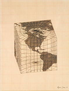
Sold2021Agnes Denes - Study of Distortions; Isometric SystemsLot 3 Agnes Denes Hungarian/American (b. 1931) Study of Distortions; Isometric Systems in Isotropic Space-Map Projections: The Cube (1975) gouache and ink on graph paper and mylar signed lower right sSee Sold Price
Sold2018Bleau Map of AsiaBLAEU, Willem Janszoon (1571-1638). Asia Noviter Delineata…Engraved map with original hand color. Amsterdam, c. 1618-1650. 20 x 24 inches sheet, 25 1/8 x 21 3/8 inches framed This is one of the mostSee Sold Price
Sold20241863 Johnson Map of Asia -- Johnson's AsiaTitle: 1863 Johnson Map of Asia -- Johnson's Asia Cartographer: Johnson & Ward Year / Place: 1863, New York Map Dimension (in.): 12.7 X 15.6 in. This is a very attractive and elaborate map of Asia. ItSee Sold Price
Sold2017Mercator (Gerard) - Atlas sive Cosmographicae,Editio Quinta, engraved pictorial title, prelims, 49 double-page maps, including Asia, Russia, Turkey, Lithuania, Asia Minor and Persia, regions of Italy Spain, Germany and Eastern Europe, and 11 singSee Sold Price
Sold202019th C. Indonesian Copper Currency - Loda**First Time At Auction** Southeast Asia, Indonesia, Sumba Island, ca. 19th to early 20th century CE. A striking example of copper currency known as "loda", used as a bride price or for negotiating coSee Sold Price
Sold2015De Bry (Theodore) - Descriptio Hydrographicathe 2-sheet map of Africa and Asia, from the east coast of Brazil to Japan, charting the first Dutch voyage to the East Indies by Houtman, large titlecartouche upper centre of right sheet, ships, compSee Sold Price
Sold2022MACLEOD, Alexander Samuel (1888-1956). A Map of Honolulu an...MACLEOD, Alexander Samuel (1888-1956). A Map of Honolulu and the Sandwich Islands which we now call the Hawaiian Islands. 1927. New York: Henry M. Snyder. Scarce and detailed map of Honolulu, with anSee Sold Price
Sold2022Donald Baechler, Coney Island 2Donald Baechler Coney Island 2 1994screenprint in colors 29 h × 29 w in (74 × 74 cm) Signed to lower edge '27/75 Donald Baechler 94'. This work is number 27 from the edition of 75See Sold Price
Sold2017George Chann (1913 - 1995 Los Angeles, CA)''And Little Blue Islands are One with the Sky'' Oil on canvas Signed lower left: Geo. Chann and with the artist's device, titled on a gallery label affixed verso 30'' H x 38'' W Provenance: Ankrum GaSee Sold Price
Sold2024Map of United States of North America, 1785Map of United States of North America, 1785, The Royal Islands of Newfoundland. 26 3/4 x 32 3/4 in framed. 19 x 25 in unframed.Local Pick up call one day before to make an appointment. TO SHIP THIS ITSee Sold Price
Sold2024Pownall Map of North America with the West India IslandsPOWNALL, Thomas (1720-1805). A New Map of North America with the West India Islands, divided according to the Preliminary Articles of Peace, Signed at Versailles, 20, jan 1783, wherein are particularlSee Sold Price
Sold2022Christo and Jeanne-Claude SURROUNDED ISLANDS PROJECT FOR BISCAYNE BAY, GREATER MIAMI, FLORIDA MixedChristo and Jeanne-Claude (1935-2020 and 1935-2009) SURROUNDED ISLANDS PROJECT FOR BISCAYNE BAY, GREATER MIAMI, FLORIDA (SCHELLMANN 132) Color screenprint, photograph, collotype and collage of map, maSee Sold Price
Sold2016Celebrated 16th Century World Map by Abraham OrteliusTypvs Orbis Terrarvum, Antwerp, dated 1587, with hand-coloring; Spanish text on the back credits the cartographer's sources in this updated edition showing the Solomon Islands and a corrected South AmSee Sold Price
Sold2022TURKISH EMPIRE AND ASIA MINOR SPEED (JOHN) The Turkish Empire, 1676; and 7 other maps of Turkish...TURKISH EMPIRE AND ASIA MINOR SPEED (JOHN) The Turkish Empire, double-page engraved map, 8 city views (including Constantinople, Damascus, Jerusalem and Alexandria) in upper border, 10 costumed figurSee Sold Price
Sold2024AFRICAN ISLANDS.Mauritius Madagascar Madeira Canaries St Helena 1897 old mapTitle: AFRICAN ISLANDS.Mauritius Madagascar Madeira Canaries St Helena 1897 old map Description: Madagascar; St. Helena; Cape Town; Aden; Ascension; Mauritius; Socotra; Perim I. and Aden; Amirante andSee Sold Price
Sold2023Rare 1925 Map of The Town and Harbor of Nantucket by Phillip L. HallRare 1925 Map of The Town and Harbor of Nantucket by Phillip L. Hall, whimsical map showing the town, harbor, ships, aircraft, and prominent landmarks of the island. Overall 23 in. x 15 in.See Sold Price
Sold2022Jose Formoso Reyes Nantucket Friendship Basket with Carved Nantucket Island on the LidJose Formoso Reyes (1902-1980) Nantucket Friendship Basket with Carved Nantucket Island on the Lid, signed upon the base "Made in Nantucket, Jose Formoso Reyes 1966" with outline map of Nantucket IslaSee Sold Price
Sold2022Five Maps of NantucketFour of the island and one of Main Street, including one by Tony Sarg (German, 1880-1942) Frames loose. Sizes from 17"h x 20"w to 23"h x 34"w overallSee Sold Price
Sold2023(NORTH AMERICA.) Henricus Hondius. America Septentrionalis.(NORTH AMERICA.) Henricus Hondius. America Septentrionalis. Double-page engraved map of North America with California as an island and attractive carto-ornamentation. 19¼x23½ inches sheet siSee Sold Price
Sold2018LUCIO FONTANA - Concetto Spaziale IILucio Fontana (Italian-Argentinian, 1899 - 1968). "Concetto Spaziale II". Mixed media. 1952-1953. Signed lower right, recto; signed and titled, verso. Mounted on stiff artist board faced with black paSee Sold Price
Sold2019A GOOD SET OF EIGHT CHINESE BLACK INK BLOCKS containedA GOOD SET OF EIGHT CHINESE BLACK INK BLOCKS contained within a fitted lacquered dragon box. Ink 9.5 cm x 3.5 cm & box 22 cm x 25 cm.See Sold Price
Sold2022***Auction Highlight*** 1894-p Morgan Dollar $1 Graded Choice Unc By USCG (fc)***Auction Highlight*** 1894-p Morgan Dollar $1 Graded Choice Unc By USCG. A Corey's Pick, Bid to Win, Don't let it get Away, you might not find its equal CoinSee Sold Price
2 days LeftTrillium Antique Prints & Rare BooksPrevost after Bellin - Map of Australia (New Holland) with part of New Zealand$100(1 bid)
4 days LeftSchilb Antiquarian Rare Books1786 Voyages James Cook New Zealand Tahiti Palestine Palmyra Temple SYRIA 4v$115(7 bids)
Jul 14Schilb Antiquarian Rare Books1780 Voyages in KAMCHATKA Jan Mayen Island Russia Greenland Nova Zembla Nunavut$1(1 bid)
Jul 14Schilb Antiquarian Rare Books1780 Voyages in CARIBBEAN Antilles Jamaica Barbados Dominican Magellan Drake 2v$54(2 bids)
Jul 14Schilb Antiquarian Rare Books1780 Voyages in AMERICA Hernando de Soto Florida New York INDIANS Eskimos Canada$50(2 bids)
5 days LeftFreeman's | Hindman[Maps & Atlases] A New Map of North America, with the West India Islands...$300
7 days LeftCain Modern AuctionsPair of Wrought Iron Sconces from the Sylvester Stallone Beverly Park Home$800
5 days LeftFreeman's | Hindman[Maps & Atlases] Seutter, Matth(ias).: Novus Orbis sive America...$300(1 bid)
14 hrs LeftLos Angeles Modern AuctionsJaune Quick-to-See Smith, Untitled (from the Kalispell Series)$7,500(1 bid)


![[Maps & Atlases] A New Map of North America, with the West India Islands... (1 of 2)](https://p1.liveauctioneers.com/65/332523/179335173_1_x.jpg?height=282&quality=70&version=1717709447)


![[Maps & Atlases] Seutter, Matth(ias).: Novus Orbis sive America... (1 of 2)](https://p1.liveauctioneers.com/65/332523/179335174_1_x.jpg?height=282&quality=70&version=1717709447)


