Sold2022Antique Map of Africa - Nigeria - Ethiopia - Algeria - Kenya - Samuel John NeeleA new map of Africa from the best authorities, 1791. Technique: Engraving. Artist: Samuel John Neele. Place: London, England. Size: 10” x 8” inches / 25 cm x 21 cm.See Sold Price
Sold2024AFRICAN ANGLICAN CHURCH DIOCESES. South Africa Nigeria Kenya Zimbabwe 1897 mapTITLE/CONTENT OF MAP: 'The Dioceses of Africa 1897' DATE PRINTED: 1897 IMAGE SIZE: Approx 19.5 x 24.0cm, 7.5 x 9.5 inches (Medium) TYPE: Coloured antique map CONDITION: Good; suitable for framing. HowSee Sold Price
Sold2017Neele - General Washington's FarmSamuel John Neele (1758-1824), after work by George Washington (1732-1799) A Map of General Washington's Farm of Mount Vernon from A Drawing transmitted by the General; taken from Letters from His ExcSee Sold Price
Sold2022LOT OF PAPER CURRENCY FROM AFRICA.Featuring Comoros, Algeria, Nigeria, Kenya and Zaire.See Sold Price
Sold2018Ortelius: Antique Map of Ethipoia & East Africa, 1592Title/Content of Map: Ethipoia & East Africa. The Prester John Map by Ortelius Date Printed: 1592 Cartographer: Abraham Ortelius Material/Medium: Paper Size: 16" x 21" Hand colored copperplate engraveSee Sold Price
Sold2016Tennessee Map, Samuel Lewis & Alexander Lawson, 1804"Tennessee" Map, drawn by Samuel Lewis, engraved by Alexander Lawson, published by John Conrad & Co., Philadelphia, 1804. From "A New And Elegant General Atlas: Comprising All the New Discoveries, toSee Sold Price
Sold2017ANTIQUE MAP OF AFRICA, GERHARD MERCATOR JR.17TH CFramed engraved hand colored map, after 1600, by Gerhard Mercator Jr (his grandfather was Gerhard Mercator, Flemish, 1512-1594), "Africa Ex magna orbis terre descriptione Gerardi Mercatoris desumpta,See Sold Price
Sold2023Rare 1721 John Senex "A New Map Of The World"DESCRIPTION: Rare antique engraved map by John Senex entitled "A New Map of the World" depicting California as an island and with parts of the world still unmapped. Further featuring hand coloring, foSee Sold Price
Sold2024John Speed 1676 Original Antique Map of Virginia and Maryland No ColorAntique 1676 map of Virginia and Maryland engraved by Francis Lamb and republished by Thomas Basset & Richard Chriswell after John Speed's 1611 atlas. With "The Description of Mary-Land" text on reverSee Sold Price
Sold2024Matthaus Merian 1627 Antique Map Engraving "Virginia" from Theodore de Bry's "Grand Voyages" #1Antique 1627 map of Virginia by Matthaus Merian after John Smith's 1612 map, from Theodore de Bry's "Grand Voyages". Please see "The Philidelphia Print Shop" sheet shown in final photo. Good conditionSee Sold Price
Sold2022Antique 1719 English Map of the Chesapeake Bay by John SenexAntique early English map of the Chesapeake Bay, showing the principal settlements of this tobacco and cotton producing region. Engraved in London in 1719 by John Senex map is titled The Sea of VirginSee Sold Price
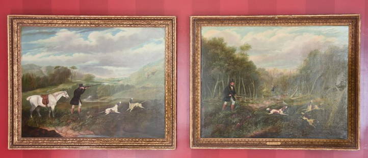
Sold2021Pair of Oil Paintings by Samuel J E JonesPair of Antique 19th C Oil Paintings by Samuel J E Jones. Each of a hunting scene, oil on canvas, framed and signed. Samuel John Egbert Jones, (1797 - 1861) was active/lived in United Kingdom. Each meSee Sold Price
Sold2023Two Yoruba "Ere Ibeji" carved wood figures with cowrie shell garmentTwo Yoruba "Ere Ibeji" carved wood figures with cowrie shell garmentLate 19th/early 20th century; Yoruba Peoples, Nigeria, AfricaAppears unmarkedTwin female statuettes held within a leather carrying bSee Sold Price
Sold2018Antique John Smith Atlantic Region Map Virginia OrigState 10: Page 41, numbers changed to 1690 and 1691. A true piece of American history, not a reproduction!Fine example of John Smith's map of the newly formed Virginia colony, one of the true milestonSee Sold Price
Sold2024John Speed 1676 Antique Hand Colored "Map of Virginia and Maryland" #2Antique 1676 hand-colored map of Virginia and Maryland engraved by Francis Lamb and republished by Thomas Basset & Richard Chriswell after John Speed's 1611 atlas. Good overall, apparent repairs, minoSee Sold Price
Sold2022EARLY MAP OF AFRICA"Africae" "Newly Done into English John Speede / G. Humble 1626" engraved by Abraham Goos, bookplate "The Description of Africa" on reverse, hand colored; minor tear, foxing, toning, tape marks; frameSee Sold Price
Sold2022John Lennon Estate Monumental Wrought Iron Samuel Yellin AndironsDESCRIPTION: A pair of antique monumental wrought iron fireplace andirons by Samuel Yellin. From John Lennon's former estate. Each feature patinated iron foundations with bronze sphere tops, supportedSee Sold Price
Sold2024Matthaus Merian 1627 Antique Hand Colored Map "Virginia" from Theodore de Bry's "Grand Voyages" #2Antique 1627 hand-colored map of Virginia by Matthaus Merian after John Smith's 1612 map, from Theodore de Bry's "Grand Voyages". Good condition overall, with age-appropriate wear, repairs (see photosSee Sold Price
Sold2023John Speed 1676 Map of Virginia, Maryland, and Chesapeake BayA MAP OF VIRGINIA AND MARYLAND by John Speed, 1676, engraved by Francis Lamb. London: Thomas Basset and Richard Chiswell. Hand colored. In addition to showing parts of Virginia and Maryland, the map aSee Sold Price
Sold2022Blair, A MAP OF NORTH AMERICA, ca. 1768A MAP OF NORTH AMERICA FROM THE LATEST SURVEYS AND MAPS, engraved by Thomas Kitchin, published by John Blair, LLD. and F.R.S., as a supplement to his "Tables of Chronology", London, ca. 1768. CopperplSee Sold Price
Sold2024John Rogers Civil War Figural Group, The Council of WarJohn Rogers (American, 1829 - 1904) painted Civil War plaster figural sculpture titled "The Council of War" depicting President Abraham Lincoln seated and examining a map with Lt. General Ulysses GranSee Sold Price
Sold2020John Ogilby "Africa" London 1670John Ogilby (1600-1676), "Africa, Being an Accurate Description of the Regions of Egypt, Barbary, Lybia, and Billedulgerid, The Land of Negroes, Guinee, Ethiopia, and the Abyssines, with all the AdjacSee Sold Price
Sold2024Henricus Hondius 1630 "Nova Virginiae Tabula" Antique Map of Virginia and the Chesapeake #2Antique map of Virginia and the Chesapeake Bay originally by Henricus Hondius in 1630 titled "Nova Virginiae Tabula". With German text on reverse final catchword "auch", signature shown in final photoSee Sold Price
Sold2020Gastaldi Map of Africa*** START PRICE IS THE RESERVE *** [Africa]. GASTALDI, Giacomo (1500-1566) & FORLANI, Paolo (fl. 1560-1571). La Descrittione dell'Africa. Engraved Map. Venice: Paolo Forlani, 1562. 19 x 25 1/4 inchesSee Sold Price
2 days LeftTrillium Antique Prints & Rare BooksPrevost - Map of Japan with part of Korea and China$50
2 days LeftTrillium Antique Prints & Rare BooksPrevost - Map of the South Pacific Ocean with New Holland (Australia), New Zealand, and part of the$50(1 bid)
2 days LeftTrillium Antique Prints & Rare BooksPrevost - Pair of Engravings of Views of Acapulco, Mexico$50


![Gastaldi Map of Africa: *** START PRICE IS THE RESERVE *** [Africa]. GASTALDI, Giacomo (1500-1566) & FORLANI, Paolo (fl. 1560-1571). La Descrittione dell'Africa. Engraved Map. Venice: Paolo Forlani, 1562. 19 x 25 1/4 inches](https://p1.liveauctioneers.com/1968/163248/82424552_1_x.jpg?height=310&quality=70&version=1583340284)