Sold20231833 JC Hales Map of Greater Boston -- MAP OF BOSTON AND ITS VICINITY From Actual Survey BY JOHN G.Title: 1833 JC Hales Map of Greater Boston -- MAP OF BOSTON AND ITS VICINITY From Actual Survey BY JOHN G. HALES Cartographer: JC Hales Year / Place: 1833 or later print Map Dimension (in.): 20.1 X 25See Sold Price
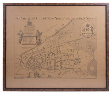
Sold2023REPLICA OF LAING'S MAP OF MANHATTAN"A Plan of the City of New York from an actual Survey" for His Excellency John Montgomerie, by William Bradford, printed on tan paper, in a faux tortoiseshell frame, under glass, 23" x 26", good condiSee Sold Price
Sold2019Christopher Greenwood (1786-1855) and John GreenwoodChristopher Greenwood (1786-1855) and John Greenwood (fl. 1821-1840) Map of the County of Essex, from an actual Survey made in the year 1824, by C & J Greenwood, 13, Regent St. Pall Mall, London, corrSee Sold Price
Sold2020Economics.- Campbell (John) A political survey ofNO RESERVE Economics.- Campbell (John) A Political survey of Britain: being a series of reflections on the situation, lands, inhabitants, revenues, colonies, and commerce of this island, 2 vol., firstSee Sold Price
Sold2019Senex & Ogilby 1719 Road Map. London to Montgomery"The Road from London to Montgomery in North Wales" Copper Engraved Map Published 1719, London for "An Actual Survey of all the Principal Roads of England and Wales" by John Ogilby and John Senex. PapSee Sold Price
Sold2020Senex & Ogilby 1719 Road Map. London to Montgomery"The Road from London to Montgomery in North Wales" Copper Engraved Map Published 1719, London for "An Actual Survey of all the Principal Roads of England and Wales" by John Ogilby and John Senex. PapSee Sold Price
Sold2021Bartholomew, John 1904 Lot of 5 British Climate MapsIncl River Basins/Tidal Flow, Mean Annual Rainfall, January/July Temp., Actual Temperature, and January/July Rainfall. Lithograph Map Published 1904, London for "The Survey Gazetteer of the British IsSee Sold Price
Sold2019New Map of Great BritainReserve Reduced! Title: New Map of Great Britain Publication Date: 1754 Cartographer: SENEX, JOHN/THOMAS BOWLES Publisher: T. BOWLES Size (inches): 36.5 x 25 Showing the extent of Public Surveys and oSee Sold Price
Sold2022Surrey.- Greenwood (C. & J.) Map of the County of Surrey from an actual Survey, made in the yearsNO RESERVE Surrey.- Greenwood (C. & J.) Map of the County of Surrey from an actual Survey, made in the years 1822 and 1823..., large county map, with vignette of Kew Palace, compass rose, calligraphicSee Sold Price
Sold2017EARLY NEW YORK STATE ACTUAL SURVEY MAPEARLY NEW YORK STATE ACTUAL SURVEY MAP FOR COUNTIES ALONG SUSQUAHANNAH RIVER, INCL. CLINTON, CHENANGO, GREEN, ETC. 18TH C. 15 1/2" X 21"See Sold Price
Sold20234 "BIRDS OF GREAT BRITAIN" JOHN GOULD PRINTS, 1873, LG FOLIO, HAND COLORED (EACH 22" X 28 1/2"4 "BIRDS OF GREAT BRITAIN" JOHN GOULD PRINTS, 1873, LG FOLIO, HAND COLORED (EACH 22" X 28 1/2" OVERALL)See Sold Price
Sold20231992-93 Chicago Bulls Team Signed Basketball1992-93 Chicago Bulls signed Spalding basketball. Signed by Michael Jordan, Scottie Pippen, Horace Grant, B.J. Armstrong, John Paxson, Will Perdue, Stacey King, Rodney McCray, Bill Cartwright, Scott WSee Sold Price
Sold2022CHINA - SHANGHAI WATERS (THOMAS JAMES) Map of the Country Around Shanghai. Compiled from the Bes...CHINA - SHANGHAI WATERS (THOMAS JAMES) Map of the Country Around Shanghai. Compiled from the Best Authorities with Numerous Additions from Actual Survey, large lithographed map, dissected into 20 secSee Sold Price
Sold2017HAND DRAWN MAP OF "HARDENBURGH PATENT GRANTED INYEAR 1704" COMPILED & LAID DOWN FROM ACTUAL SURVEY (47" X 57 1/2")See Sold Price
Sold2024Lawson's Survey Map Upper Calif Mines, c1848 [178902]Lawson's map from actual survey of the gold, silver and Quicksilver regions of upper California exhibiting the mines, diggings, roads, paths, houses, mills, stores, missions etc. by JT Lawson togetherSee Sold Price
Sold2017Plan of the City and Suburbs of New Orleans"Plan of the City and Suburbs of New Orleans; from An Actual Survey Made in 1815", by Jacques Tanesse, facsimile published Ithaca, New York: Historic Urban Plans, 1967, after the original published bySee Sold Price
Sold2017[Maps] Britannia Depicta, 1720Bowen, Emanuel. BRITANNIA DEPICTA OR OGILBY IMPROV'D; BEING A CORRECT COPPY OF MR. OGILBY'S ACTUAL SURVEY OF ALL YE DIRECT & PRINCIPAL CROSS ROADS IN ENGLAND AND WALES. London: Tho. Bowles, 1720. 8vo.See Sold Price
Sold2024The Great Fire in Southwark… Buildings Destroyed. Tooley Street. WELLER 1865 mapCAPTION PRINTED BELOW PICTURE: 'The Great Fire in Southwark - Plan of the Buildings Destroyed, from an actual survey by J.T. Loveday Esq. (of the Phoenix Fire Office)' A map of the 1861 Tooley StreetSee Sold Price
Sold2022IMPORTANT REVOLUTIONARY WAR-ERA MAP OF NEW YORK AND NEW JERSEY 1776 29” x 23” sight.IMPORTANT REVOLUTIONARY WAR-ERA MAP OF NEW YORK AND NEW JERSEY1776“A Map of the Province of New-York, Reduc'd from the large Drawing of that Province, Compiled from Actual Surveys by Order of HiSee Sold Price
Sold20243 Maps1.) Lewis Samuel, A Map of Part of the N. W. Territory of the United States: Compiled from Actual Surveys & the beft Information; 2.) The State of Ohio with Part of Upper Canada; 3.) JSee Sold Price
Sold2020New and Complete Map of Scotland, And Islands TheretoTitle/Content of Map: New and Complete Map of Scotland, And Islands Thereto Belonging; Cartographer: Date: 1779 Publisher: ROBT. SAYER Size: 46.7Height - 39.7Width "from actual surveys, the Shires proSee Sold Price
Sold2017ATLAS OF FREDERICK COUNTY MARYLAND. 1873.[Atlas] ATLAS OF FREDERICK COUNTY MARYLAND. From actual Surveys by and under the direction of D. J. Lake, C. E. Philadelphia: C. O. Titus & Co., 1873. 33 pages of local maps + folding map of MarylandSee Sold Price
Sold20241876 Antique Atlas of York County, PA (2)Two York County, Pennsylvania atlases, the first copy complete with "Atlas of York Co. Pennsylvania Illustrated from Actual Surveys" dated 1876 by and under the direction of Beach Nichols and publisheSee Sold Price
Sold2022(KENTUCKY.) J.T. Lloyd. Lloyd's Official Map of the State of Kentucky.(KENTUCKY.) J.T. Lloyd. Lloyd's Official Map of the State of Kentucky. Compiled from Actual Surveys and Official Documents, Showing Every Rail Road & Rail Road Station with the Distances Between EachSee Sold Price
2 days LeftAlbion AuctionsMillais, John 1904 Rare Folio Print. Bats - Whiskered and Bechstein Bat$5(1 bid)
2 days LeftAlbion AuctionsMillais, John 1904 Rare Folio Print. Bats - Noctule & Leister's Bat$5(1 bid)
2 days LeftAlbion AuctionsMillais, John 1904 Rare Folio Print. Bats - Naterers & Daubenton's Bat$5(1 bid)
1 day LeftRapid Estate Liquidators and Auction GalleryAtlas Railroads You Can Build & Wiring Your Layout Softcovers$5
2 days LeftThe Art's WorldJOHN NIETO - TOUCHES THE SKY - ACRYLIC PAINTING ON CANVAS - IN THE STYLE OF€6,500
2 days LeftThe Art's WorldJOHN WAYNE GACY - 7 DWARFS - OIL PAINTING ON WOODEN BOARD - IN THE STYLE OF€1,700


![Lawson's Survey Map Upper Calif Mines, c1848 [178902]: Lawson's map from actual survey of the gold, silver and Quicksilver regions of upper California exhibiting the mines, diggings, roads, paths, houses, mills, stores, missions etc. by JT Lawson together](https://p1.liveauctioneers.com/2699/324084/174414792_1_x.jpg?height=310&quality=70&version=1711485923)

![[Maps] Britannia Depicta, 1720: Bowen, Emanuel. BRITANNIA DEPICTA OR OGILBY IMPROV'D; BEING A CORRECT COPPY OF MR. OGILBY'S ACTUAL SURVEY OF ALL YE DIRECT & PRINCIPAL CROSS ROADS IN ENGLAND AND WALES. London: Tho. Bowles, 1720. 8vo.](https://p1.liveauctioneers.com/3532/111460/57224161_1_x.jpg?height=310&quality=70&version=1509131847)


![ATLAS OF FREDERICK COUNTY MARYLAND. 1873.: [Atlas] ATLAS OF FREDERICK COUNTY MARYLAND. From actual Surveys by and under the direction of D. J. Lake, C. E. Philadelphia: C. O. Titus & Co., 1873. 33 pages of local maps + folding map of Maryland](https://p1.liveauctioneers.com/179/104231/53361903_1_x.jpg?height=310&quality=70&version=1495213319)


