Sold2016Green's History of the English People finely boundHeading: (Fine Bindings) Author: Green, John Richard Title: History of the English People Place Published: London Publisher:Macmillan and Co. Date Published: 1881 Description:See Sold Price
Sold2021Bartholomew, John 1904 Lot 5 UK Farming/Industry MapsIncl distribution of Land under Crops/Pasture Land, Green Crops/Corn Crops, Cattle/Sheep, Coal/Iron, and Textile/Hardware Manufactures. Lithograph Maps Published 1904, London for "The Survey GazetteerSee Sold Price
Sold2017[Playing Cards] Two Historical Works on Cards.[Playing Cards] Two Historical Works on Cards. Including The Devil’s Picture Books (New York: Dodd, Mead, 1893) by Mrs. John King Van Rensselaer, with green publisher’s cloth, stamped in silver, iSee Sold Price
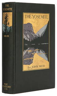
Sold2023 MUIR, John (1838-1914). The Yosemite. New York: The Century...MUIR, John (1838-1914). The Yosemite. New York: The Century Co., 1912. 8vo. 32 full-page plates from photographs, 3 folding maps. Original pictorial dark green cloth, top edge gilt (small spot of ghosSee Sold Price
Sold2019[Ireland] Savage, John, Thomas Kelly, New York, 1878,[Ireland] Savage, John, Thomas Kelly, New York, 1878, Picturesque Ireland with 33 color maps and 29 engraved plates; large, thick quarto, contemporary three-quarter green morocco, bevelled boards, raiSee Sold Price
Sold20218 vols. History of Ireland. 1 sgd.[Ireland] 8 volumes. Barrow, John. A Tour Round Ireland Through the sea-coast counties in the Autumn of 1835. 8vo. xi, 379, 38 pp. Folding map, 8 plates. Green cloth, paper spine label. ++ Synge, J.M.See Sold Price
Sold2021SCARCE OZ BOOK"Tik-Tok of Oz" by L. Frank Baum, Illustrated by John R. Neill, Reilly & Britton Co. Chicago, 1914. Green cloth binding with black title on spine, applied full front board illustration, map of Oz on eSee Sold Price
Sold2022John Smith Map of New England, Extremely Rare 2nd StateSMITH, John (1580-1631). New England the most remarqueable parts thus named by the high and mighty Prince Charles, Prince of great Britaine. Observed and described by Captayn John Smith... CopperplateSee Sold Price
Sold2022(PICTORIAL MAPS.) John Diakoff; G. Primakoff; and P. Sergeeff. Map of China.(PICTORIAL MAPS.) John Diakoff; G. Primakoff; and P. Sergeeff. Map of China. Enormous chromolithographed map of China with profuse pictorial illustration, inset charts, reference tables, and scenic viSee Sold Price
Sold2021John Wells James (American, 1873-1951) Village SceneJohn Wells James (American, 1873-1951) Village Scene Dedicated 'to Ray & John Green from Halsted James March 1953' verso, oil on canvasboard (12 5/8 x 15 3/4 in. (32.1 x 40cm)) Provenance TheSee Sold Price
2023ROLEX JOHN MAYER GREEN DIALRetail Price: $190,000.00/ ROLEX BRAND NEW JOHN MAYER/ 2021/ COMPLETE SET/ BOX AND PAPERS/ REF: ART100RLXSee Sold Price
Sold2022John Deere Green Quality Farm Equipment Porcelain SignIncredible John Deere Green Quality Farm Equipment Double Sided Porcelain Bullnose Dealership Sign TAC 8.75 & 8.25. Two SSP (single sided porcelain) sleigh-style signs mounted back-to-back with privilSee Sold Price
Sold2021John Kacere, Green Slip - Yellow Panties, 1975John Kacere(1920 - 1999)Green Slip - Yellow Panties, 1975oil on canvasinscribed verso: J. KACERE "P.S." 15" x 20" / John Kacere '7515 x 20 in. (38.10 x 50.80 cm.), Frame: 17 1/2 xSee Sold Price
Sold2022(BERMUDA.) Major General John Henry Lefroy. Map of the Bermudas.(BERMUDA.) Major General John Henry Lefroy. Map of the Bermudas. Hand-colored lithographed wall map of Bermuda with inset diagrams and statistical tables on 4 sheets joined. 51½x60 inches overallSee Sold Price
Sold2022[MAPS]. MELISH, John (1771-1821). United States of America Compiled form the latest & bet[MAPS]. MELISH, John (1771-1821). United States of America Compiled form the latest & bet Authorities. Philadelphia: Murray Draper Fairman & Co., 1818. Engraved map of the eastern United States,See Sold Price
Sold2023John Speed 1676 Map of Virginia, Maryland, and Chesapeake BayA MAP OF VIRGINIA AND MARYLAND by John Speed, 1676, engraved by Francis Lamb. London: Thomas Basset and Richard Chiswell. Hand colored. In addition to showing parts of Virginia and Maryland, the map aSee Sold Price
Sold20226' John Deere Quality Farm Equipment SS Porcelain Sign6' John Deere Green Quality Farm Equipment Single Sided Porcelain Sign TAC 9. SSP (single sided porcelain) sign has excellent color and gloss with a few light marks in the field and a chip at the loweSee Sold Price
Sold2024Larkin Goldsmith Mead (after), marble bustLarkin Goldsmith Mead (after), marble bust, After Larkin Goldsmith Mead (American, 1835-1910), Neoclassical Woman, white statuary marble, signed "Copy, LG Mead" verso, on green marble pedestal, 22"h xSee Sold Price
Sold2015Kingdom of IrelandJohn Speed (1552-1629). Engraved map. London: 1610 (1676). 17 1/4 x 22 inches. A rare, early printing of John Speed’s renowned map of Ireland. The map is decorated with a panel of costume figures deSee Sold Price
Sold2022Real estate in Balboa Park, S.F.Heading: -1911 Author: Punnett, John M. Title: Map of Mission Terrace San Francisco California Place Published: San Francisco Publisher:Baldwin & Howell Date Published: 1911 DescriptionSee Sold Price
2016ANDY WARHOL - Marker drawing on posterAndy Warhol (American, 1928 - 1987). "$ [dollar sign] [marker drawing on poster]". Marker drawing on poster. 1969. Signed in black marker, lower center. Light green watermarked Mead Mimeo Bond paper.See Sold Price
Sold2016JOHN SPEED (BRITISH, 1552-1629) MAP OF THE WORLDJOHN SPEED (BRITISH, 1552-1629) MAP OF THE WORLD, (UPDATED 6/14/16) hand-colored engraving on laid paper, titled "A New and Accurat Map of the World Drawne according to ye truest Descriptions latest DSee Sold Price
Sold2021after John James Audubon-American Green Winged TealLot 3A after John James Audubon American Green Winged Teal, Plate CCXXVIII (19th Century) engraving with aquatint and hand-coloring plate: 12 1/4 x 19 1/4 inches sheet: 25 1/2 x 38 1/5 inches ProvenanSee Sold Price
Sold2024John Senex (1678-1740) 1710 Map of the Holy Land IsraelJohn Senex ( 1678 - 1740 ) 18th Century Rare 1710 Engraved titled "A Map of the Holy Land " " Divided into the XII Tribes of Israel wherein is exactly marked ye travels of Jesus Christ " Original handSee Sold Price
May 21Hess Fine Auctions1885 A Popular History Of The United States JC Ridpath Gilt Green Leather Book Illustrated$10
1 hr LeftCambridge AuctionsVintage JOHN DEERE Toy Tractor and Grain Drill with Boxes 1950's-1960's MIB$330(3 bids)
7 days LeftTremont AuctionsJohn Speed and Francis Lamb "Map of New England and New York", ca. 1676. Hand colored engraved map$900(3 bids)
7 days LeftTremont Auctions17th century original map 1676 "Virginia and Maryland" by John Speed. 2 sided framing. Overall:$325(2 bids)


![[Playing Cards] Two Historical Works on Cards.: [Playing Cards] Two Historical Works on Cards. Including The Devil’s Picture Books (New York: Dodd, Mead, 1893) by Mrs. John King Van Rensselaer, with green publisher’s cloth, stamped in silver, i](https://p1.liveauctioneers.com/928/102376/52307140_1_x.jpg?height=310&quality=70&version=1491604828)
![[Ireland] Savage, John, Thomas Kelly, New York, 1878,: [Ireland] Savage, John, Thomas Kelly, New York, 1878, Picturesque Ireland with 33 color maps and 29 engraved plates; large, thick quarto, contemporary three-quarter green morocco, bevelled boards, rai](https://p1.liveauctioneers.com/197/143669/72658568_1_x.jpg?height=310&quality=70&version=1559851603)
![8 vols. History of Ireland. 1 sgd.: [Ireland] 8 volumes. Barrow, John. A Tour Round Ireland Through the sea-coast counties in the Autumn of 1835. 8vo. xi, 379, 38 pp. Folding map, 8 plates. Green cloth, paper spine label. ++ Synge, J.M.](https://p1.liveauctioneers.com/179/209052/106367408_1_x.jpg?height=310&quality=70&version=1624651037)


![[MAPS]. MELISH, John (1771-1821). United States of America Compiled form the latest & bet: [MAPS]. MELISH, John (1771-1821). United States of America Compiled form the latest & bet Authorities. Philadelphia: Murray Draper Fairman & Co., 1818. Engraved map of the eastern United States,](https://p1.liveauctioneers.com/197/265300/138516600_1_x.jpg?height=310&quality=70&version=1666052782)


![ANDY WARHOL - Marker drawing on poster: Andy Warhol (American, 1928 - 1987). "$ [dollar sign] [marker drawing on poster]". Marker drawing on poster. 1969. Signed in black marker, lower center. Light green watermarked Mead Mimeo Bond paper.](https://p1.liveauctioneers.com/963/84053/45305864_1_x.jpg?height=310&quality=70&version=1462567456)


