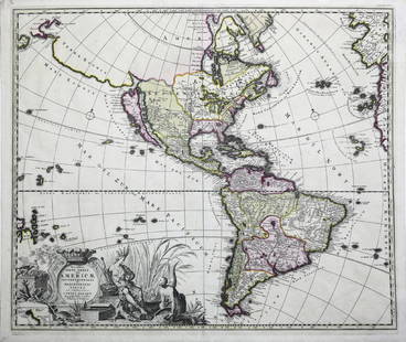
Arader Galleries September 2017 Auction 2017-09-23 Auction - 225 Price Results - Arader Galleries in NY - Page 6
LiveAuctioneers Logo

Audubon Aquatint Engraving, Brown Pelican, Plate 421Audubon Aquatint Engraving, Wood Ibis, Plate 216Tussac's Flore des Antilles
Done
New York, NY, United States
Auction Details

Arader Galleries September 2017 Auction

This auction features stunning examples from John James Audubon's Birds of America as well as natural history prints and watercolors, a selection of fine rare books and manuscripts, and an outstanding offering of maps and views.
Lot Number: Lowest
24
Sold
Munster's Updated Map of America: Americae Sive Novi Orbis Nova Descriptio. Sebastian Munster (1488-1552). Woodcut map with hand color in full. Basel: Petri, 1588. 13 x 14 3/4 inches visible, 20 1/4 x 22 inches framed. From a later
0121: Munster's Updated Map of AmericaEst. $800-$1,200
See Sold Price
Sold
Ortelius's Famous Map of America: Americae sive Novi Orbis Nova Descriptio. Abraham Ortelius (1527-1598). Engraved map with hand color in full. Antwerp, c. 1587 (1598 dutch text). 14 1/2 x 20 inches visible, 25 1/2 x 31 inches
0122: Ortelius's Famous Map of AmericaEst. $2,000-$3,000
See Sold Price
Sold
Rare Michael Mercator Map of the Americas: America sive India Nova...Michael Mercator (c. 1567-1600). Engraved map with original hand color. Duisburg, 1595 (but Hondius: Amsterdam, 1613 or later). 15 x 18 1/2 inches visible, 26 x 29 inches
0123: Rare Michael Mercator Map of the AmericasEst. $2,500-$3,500
See Sold Price
Sold
Hondius Engraved Map of America: America. Jodocus Hondius (1563-1612). Engraved map with original hand color. Amsterdam, 1606 (1619). 18 1/2 x 22 1/2 inches sheet. Jodocus Hondius’ map of the Americas is one of the most elaborate
0124: Hondius Engraved Map of AmericaEst. $2,500-$4,000
See Sold Price
Sold
Engraved Map of America by Merian: America noviter delineata. Matthäus Merian (1539-1650). Engraved map with hand color in part. Frankfurt, c. 1631. 14 1/4 x 18 inches visible, 24 1/2 x 28 inches framed. An uncommon map of America by
0125: Engraved Map of America by MerianEst. $600-$800
See Sold Price
Blaeu Nova Belgica: Nova Belgica Et Anglia Nova. Willem Blaeu (1571-1638). Engraved map with original hand color in part. Amsterdam, 1635 (1638). 16 x 20 1/2 inches visible, 24 x 28 1/2 inches framed. This important map
0126: Blaeu Nova BelgicaEst. $2,000-$3,000Lot Passed
Sold
Blaeu Engraved Map of North America: Americae Nova Tabula. Willem Blaeu (1571-1638). Engraved map with original hand color. Amsterdam, c. 1645 or later (state 5). 17 x 22 3/4 inches visible, 27 x 33 inches framed. This is one of the few
0127: Blaeu Engraved Map of North AmericaEst. $3,000-$5,000
See Sold Price
Sold
Hennepin Map of North America: Carte d’un tres grand pais...Louis de Hennepin (1626-1704). Engraved map with original hand color. 1698 (Leiden: 1704, state 3). 15 3/4 x 18 1/4 sheet. This significant map of eastern North America
0128: Hennepin Map of North AmericaEst. $1,800-$3,000
See Sold Price
Sold
18th Century French Map of North America: L’Amerique Septentrionale. Daniel de la Feuille (1640-1709). Engraved map with hand color in full. Amsterdam, 1702 or 1706. 6 x 8 inches visible, 13 x 14 1/2 inches framed. Nicely colored early
0129: 18th Century French Map of North AmericaEst. $1,200-$1,800
See Sold Price
Sold
Chatelain Map of New France: Carte de la Nouvelle France...Henri Chatelain (1684-1743). Engraved map. Amsterdam, 1705-1720. 19 1/4 x 22 1/4 inches sheet. Chatelain’s one sheet version of De Fer’s 1718 map proved very
0130: Chatelain Map of New FranceEst. $2,500-$4,000
See Sold Price
Sold
Homann Map of American Colonies: Nova Anglia. Johann Baptiste Homann (1664-1724). Engraved map with original hand color. Nuremberg, c. 1716. 20 1/2 x 24 inches sheet. The map shows that as the number of English settlements increased
0134: Homann Map of American ColoniesEst. $1,000-$1,500
See Sold Price
1855 Wall Map of US and Mexico: Map of the United States with its Territories: Also Mexico and the West Indies … 1855 [Wall Map]. Lithographed wall map with hand color. New York: Ensign, Bridgman & Fanning, 1855. 36 1/2 x 35 1/2
0135: 1855 Wall Map of US and MexicoEst. $1,200-$2,000Lot Passed
Sold
Mitchell Wall Map of America: Mitchell’s National Map of the American Republic. Samuel Augustus Mitchell (1790-1860). Engraved map with original hand color in full. Philadelphia, 1843. 41 x 48 inches sheet, 48 x 55 inches
0136: Mitchell Wall Map of AmericaEst. $1,500-$2,500
See Sold Price
Sold
Extremely rare map of North America by Forlani: Il Disegno Del Discoperto Della Nova Franza, il quale s’e hauuto ultimamente dalla nouissima nauigatione de’ Franzesi in quel luogo. Paolo Forlani (fl.1560-71). Engraved map. Venice: Bolognino
0137: Extremely rare map of North America by ForlaniEst. $75,000-$100,000
See Sold Price
Sold
Champlains Definitive Map of New France: Carte de la nouvelle France from Les Voyages de la Novvelle France Occidentale, dicte Canada . Samuel de Champlain (c. 1567 - 1635). Copper-plate engraving on two sheets. Paris: 1632. 20 1/2 x 34
0138: Champlains Definitive Map of New FranceEst. $65,000-$80,000
See Sold Price
Sold
Hondius World Map: Nova Totius Terrarum Orbis Geographica...Henricus Hondius (1597-1651). Engraved map with original hand color. Amsterdam, 1630. 17 1/2 x 21 3/4 inches sheet. This beautiful world map is considered to
0139: Hondius World MapEst. $8,000-$10,000
See Sold Price
Sold
Thevet World Map: Quarte partie du Monde. Andre Thevet (1516-1590). Woodcut map. Paris, c. 1575. 14 1/2 x 19 inches sheet. A splendid example of woodblock printing, this map’s relatively advanced cartography is
0140: Thevet World MapEst. $6,000-$10,000
See Sold Price
Sold
THE ONLY SURVIVING ORIGINAL MANUSCRIPT OF THE FIRST: Survey and Town Plan of Pittsburgh, Pennsylvania. Colonel George Woods. Pen and ink on parchment. Pittsburgh, 1784. 13 ½ x 17 ¼ inches sheet. Provenance: Senator James Ross (1762-1847); Private
0141: THE ONLY SURVIVING ORIGINAL MANUSCRIPT OF THE FIRSTEst. $75,000-$100,000
See Sold Price
Sold
First Official Plan of Washington: Plan of the City of Washington…Andrew Ellicott (1754-1820). Engraved Map by J. Thackara & J. Vallance: Philadelphia, 1792. 12 1/4 x 15 1/4 inches sheet, 22 x 25 inches framed. First Official Plan
0142: First Official Plan of WashingtonEst. $8,000-$12,000
See Sold Price
Mortier Map of Chesapeake Bay: Carte Particuliere Virginie, Maryland, Pennsilvanie, La Nouvelle Jarsey Orient et Occidentale. Pierre Mortier (1661-1711). Engraved map with original hand color in outline. Amsterdam, c. 1700. 24 x
0143: Mortier Map of Chesapeake BayEst. $6,000-$7,000Lot Passed
Sold
Lescarbot Map of New France: Figure De La Terre, Neuve, Grande Riviere De Canada, Et Côtes De L’Ocean En La Nouvelle France. Marc Lescarbot (1570-1641). Copper-plate engraving. Paris, 1609. 7 3/4 x 17 1/2 inches. This is the
0144: Lescarbot Map of New FranceEst. $50,000-$70,000
See Sold Price
View:
24
TOP