Antique Maps, Engravings, Prints & Books 2023-03-08 Auction - 248 Price Results - Old World Auctions in VA - Page 9
LiveAuctioneers Logo

MAP, New England USA, GoosMAP, Africa, WitMUSIC, Music, Liechtenstein
Done
Richmond, VA, United States
Auction Details

Antique Maps, Engravings, Prints & Books

This auction features over 250 original and rare maps, charts, atlases, engravings, historical documents, and books from the 16th to early 20th centuries. Each item in the auction is accompanied by a Certificate of Authenticity. Please contact us if you have any questions about the items in the auction - we are happy to help!
Lot Number: Lowest
24
Sold
MAP, Japan, Bellin: Japan. Jacques Nicolas Bellin, Carte de l'Empire du Japon, from Prevost's Historische Beschryving de Reizen..., 1752 (dated). Black & White. This is a Dutch version of Bellin's influential map made
0202: MAP, Japan, BellinEst. $200-$230
See Sold Price
Sold
MAP, Japan, Yamashita: Omi Province, Japan. Shigemasa Yamashita, [Omi Province] ?mi no Kuni saikenzu, 1824 (circa). Black & White. This wall-sized woodblock map of the Omi Province was created by Shigemasa Yamashita.
0203: MAP, Japan, YamashitaEst. $475-$600
See Sold Price
Sold
MAP, Philippines, Bellin: Southern Philippines. Jacques Nicolas Bellin, Carte des Isles Philippines Dressee sur la Carte Espagnole du R.P. Murillo de Velarde. 2e. Feuille..., from Histoire Generale des Voyages, 1752 (dated).
0204: MAP, Philippines, BellinEst. $160-$190
See Sold Price
MAP, Indonesia, Bonne: East Indies - Indonesia. Rigobert Bonne, Carte des Isles de la Sonde, et des Isles Moluques, from Atlas de Toutes les Parties Connues du Globe Terrestre, 1780 (circa). Hand Color. Great little map
0205: MAP, Indonesia, BonneEst. $120-$150Lot Passed
MAP, Indonesia, Jansson: Java, Indonesia. Jan Jansson, Insulae Iavae cum Parte Insularum Borneo Sumatrae, et Circumjacentium Insularum Novissima Delineatio, 1680 (circa). Hand Color. This elegant chart focuses on the
0206: MAP, Indonesia, JanssonEst. $700-$850Lot Passed
MAP, Indonesia, Jansson: Bacan Islands, Maluku Islands. Jan Jansson, Insularum Moluccarum Nova Descriptio, from Atlas Minor, 1648 (circa). Hand Color. This is a reduced version of Jansson's map of the Spice Islands, the
0208: MAP, Indonesia, JanssonEst. $110-$140Lot Passed
Sold
MAP, India, Aa: Picture-Frame Style Border. India. Pieter van der Aa, L'Inde de ca le Gange, Suivant les Nouvelles Observations de Messrs. de l'Academie Royale des Sciences, Etc. Augmentees de Nouveau, 1720
0209: MAP, India, AaEst. $275-$350
See Sold Price
Sold
MAP, India, Bonne: Northern India. Rigobert Bonne, Carte de la Partie Superieure de l'Inde en Deca du Gange, Comprise Entre la Cote du Concan et Celle d'Orixa..., 1770 (circa). Hand Color. A nice small map of
0210: MAP, India, BonneEst. $80-$95
See Sold Price
MAP, India, Aa: India, Natives. Pieter van der Aa, Lieu de Combats pour le Divertissement du Grand Mogol [on sheet with] Habit des Hommes et Femmes Maures dans les Indes [and] Carosses a Suratte Tirez par des
0211: MAP, India, AaEst. $90-$110Lot Passed
MAP, Asia, Hondius: Southern & Southeast Asia. Hondius/Jansson, India quae Orientalis Dicitur, et Insulae Adiacentes, from Atlas Novus, 1646 (circa). Hand Color. This handsome chart of Southeast Asia was one of a
0212: MAP, Asia, HondiusEst. $1,400-$1,700Lot Passed
Sold
MAP, Asia, Bonne: Western & Southern Asia. Bonne/Lattre, [On 4 Sheets] Mappa Imperiorum Antiquorum, from Atlas Moderne, 1783 (circa). Hand Color. A detailed historical map on 4 sheets depicting the Middle East,
0214: MAP, Asia, BonneEst. $240-$300
See Sold Price
MAP, Africa, Wit: De Wit's Uncommon Carte-a-Figures Map of Africa. Africa. Frederick de Wit, Nova Africa Descriptio, 1660 (circa). Hand Color. This is De Wit's uncommon map of Africa, first published in 1660 in a
0215: MAP, Africa, WitEst. $2,400-$3,000Lot Passed
Sold
MAP, Africa, Robert de Vaugondy: Africa. Gilles Robert de Vaugondy, L'Afrique Divisee en ses Principaux Empires et Royaumes par les Srs. Sanson..., 1749 (dated). Hand Color. Gilles Robert de Vaugondy succeeded his uncle, Pierre
0216: MAP, Africa, Robert de VaugondyEst. $325-$400
See Sold Price
MAP, Africa, Bonne: Africa. Rigobert Bonne, Afrique, 1770 (circa). Hand Color. Most detail on this nice map of the African continent is limited to the coasts and northern regions, with the interior left mostly blank.
0217: MAP, Africa, BonneEst. $110-$140Lot Passed
MAP, Africa, Keulen: Northern Africa. Johannes van Keulen, Nieuwe Pascaart voor een Gedeelte van de Zeekusten van Barbaria Beginnende van C: Rusato tot Alexandria als Mede t' Meeste Gedeelte van t' Eylandt Candia, 1720
0218: MAP, Africa, KeulenEst. $200-$230Lot Passed
Sold
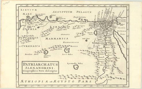
MAP, Africa, Moll: Northern Africa. Herman Moll, Patriarchatus Alexandrini. Geographica Nova Descriptio, from The Works of the Learned Joseph Bingham..., 1726 (published). Black & White. Engraved in Herman Moll's
0219: MAP, Africa, MollEst. $120-$150
See Sold Price
MAP, Algiers, Munster: Algiers, Algeria. Sebastian Munster, Algier, from Cosmographia, das Ist Beschreibung der Gantzen Welt, 1628 (published). Hand Color. Woodblock illustration of the mighty fortress of Algiers, a
0220: MAP, Algiers, MunsterEst. $100-$130Lot Passed
Sold
MAP, Africa, Mercator: Northwestern Africa. Mercator/Hondius, Fessae Regnum, from Atlas Minor, 1609 (published). Hand Color. This charming small map of Morocco and Algeria extends south to Beninia and Nussini and
0221: MAP, Africa, MercatorEst. $140-$170
See Sold Price
MAP, Africa, Braun & Hogenberg: Northwestern Africa Cities. Braun & Hogenberg, Tunes, Oppidum Barbarie & Regia Sedes; Anno 1535... [on sheet with] Africa, Aphrodisium [and] Penon de Velles, from Civitates Orbis Terrarum, Vol. II,
0222: MAP, Africa, Braun & HogenbergEst. $240-$300Lot Passed
MAP, Egypt, Fer: Egypt. Nicholas de Fer, Le Cours du Nil, Suivant les Auteurs Modernes et les Dernieres Relations, from Atlas ou Recueil de Cartes Geographiques, 1720 (dated). Hand Color. This is de Fer's detailed
0223: MAP, Egypt, FerEst. $275-$350Lot Passed
Sold
PRINT, Egypt, Roberts: Beni Hasan, Egypt. David Roberts, Entrance to the Caves of Beni Hassan, from The Holy Land, Syria, Idumea, Arabia, Egypt & Nubia, 1848 (circa). Hand Color. David Roberts, R.A. (1796-1864) was one
0224: PRINT, Egypt, RobertsEst. $200-$230
See Sold Price
Sold
PRINT, Egypt, Roberts: Wady Kardassy, Egypt. David Roberts, Temple of Wady Kardassy, Nubia, from The Holy Land, Syria, Idumea, Arabia, Egypt & Nubia, 1848 (dated). Hand Color. David Roberts, R.A. (1796-1864) was one of
0225: PRINT, Egypt, RobertsEst. $200-$230
See Sold Price
Sold
MAP, Africa, Fer: Eastern Africa. Nicholas de Fer, Partie Orientale d'Afrique ou se Trouvent l'Egipte, la Nubie, l'Abissine, et l'Ajan..., from Atlas Curieux, 1703 (dated). Hand Color. This map covers from Tunis and
0226: MAP, Africa, FerEst. $140-$170
See Sold Price
View:
24
TOP