Atlases, Continent, World & Celestial Maps 2019-12-31 Auction - 161 Price Results - Jasper52 in NY
LiveAuctioneers Logo

1792 Elwe World Map -- Mappe Monde ou Description du9 inch Terrestrial globe  HIX Short Wave radio stations1928 Clegg Map of the Flights of Charles Lindbergh --
Done
New York, NY, United States
Auction Details

Atlases, Continent, World & Celestial Maps

Jasper52

Jasper52

badge TOP RATED
Explore both terrestrial and celestial realms through this comprehensive map and atlas sale, which preserves the geography of nearly every region imaginable. Global, continental, and astronomical focused maps paired with a selection of Atlases provide a fantastic overview of our world as it was viewed both in past and present times. Discover sites such as the Ancient World or the constellations of the northern night sky! Not only will these maps and atlases serve as decorative collectors pieces, but they also will reveal innumerable ways to view our world.
Lot Number: Lowest
24
Hammond's 6 inch Terrestrial Globe: Title/Content of Map: Hammond's 6 inch Terrestrial GlobeDate: 1930Publisher: C.S. Hammond & Co. Dull paper gores over pasteboard, time dial at North Pole. Oceans finished pea green with nautical
0003: Hammond's 6 inch Terrestrial GlobeEst. US$550-US$700Lot Passed
Huntington's School Atlas: Title/Content of Map: Huntington's School AtlasDate: 1834Cartographer: HUNTINGTON, NATHANIEL GPublisher: E. HUNTINGTON & COSize: 11.5"H x 9.8"W drawn and engraved expressly to illustrate and
0004: Huntington's School AtlasEst. US$450-US$550Lot Passed
Sold
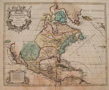
1792 Elwe Map of North America -- Amerique: Title/Content of Map: 1792 Elwe Map of North America -- Amerique Septentrionale Divisee en Ses Principales PartiesCartographer: J ElweDate: 1792, AmsterdamSize: 18.3 X 23.1 in. This is an
0005: 1792 Elwe Map of North America -- AmeriqueEst. US$1,000-US$1,200
See Sold Price
Sold
Scarce 1850 plants distribution: Scarce 1850 map or chart by Joseph Meyer depicting plant geography. Shows the distribution of vegetation throughout the world. Features five illustrations showing the vegetation in various regions,
0008: Scarce 1850 plants distributionEst. US$90-US$110
See Sold Price
1876 Atlas of Noble County, Ohio: Illustrated Atlas of Noble County, Ohio published from Actual Surveys. Pub. 1876 by Wall, Mann & Hall. Spine, tips and hinges have been reinforced. Cover cloth worn through at some spots on top and
0010: 1876 Atlas of Noble County, OhioEst. US$265-US$365Lot Passed
Atlas of Ancient and Modern History: Title/Content of Map: Atlas of Ancient and Modern History;Date: 1845Cartographer: [MITCHELL, SAMUEL AUGUSTUS] J.W. TYSON, A.BPublisher: S. AUGUSTUS MITCHELLSize: 13.5"H x 10.5"W presenting, in a
0011: Atlas of Ancient and Modern HistoryEst. US$250-US$300Lot Passed
Sold
Old' and 'New' hemispheres: Title/Content of Map: Old' and 'New' hemispheres.Cartographer: Pierre TardieuDate Printed:1830Material/Medium: PaperSize: Size Image 40 x 21 cm. Size Frame 55 x 36 An unusual double hemisphere world
0015: Old' and 'New' hemispheresEst. US$150-US$180
See Sold Price
N. America map, 1886: “Map of N. America showing its Political Divisions and Recent Discoveries in the Polar Regions,” by William Bradley. Taken from Mitchell’s 1887 New General Atlas. Large British America with
0020: N. America map, 1886Est. US$110-US$135Lot Passed
Sold
Rare 1st ed. 1847 ethno map of Europe/Asia: A large full color map of Europe and Asia showing the ethnographic distribution of people. Includes an accompanying chart. From the first comprehensive physical atlas of the world. This map comes
0022: Rare 1st ed. 1847 ethno map of Europe/AsiaEst. US$90-US$110
See Sold Price
Sold
People's Handy Atlas of the World: Title/Content of Map: People's Handy Atlas of the WorldDate: c1911Cartographer: GEOGRAPHICAL PUBLISHING COPublisher: GEOGRAPHICAL PUBLISHING COSize: 7.9"H x 5.8"W (1910 Census edition) Containing
0023: People's Handy Atlas of the WorldEst. US$80-US$100
See Sold Price
View:
24
TOP