Sold2021Boating maps, Spanish wells to Harbor Island, cays toMaps from 1981 tropic Isle publishers, Inc By Harry Kline, Spanish wells to Harbor Island, cays to Eleuthera, current cut and current settlement. Size 11“ x 17“See Sold Price
Sold2021Boating maps, Powell Point to rock sound, EleutheraMaps from 1981 tropic Isle publishers, Inc By Harry Kline, Powell point to rock sound, Eleuthera island, Spanish wells and ridley head channel. Size 11“ x 17“See Sold Price
Sold2021Boating maps, the Jumentos Cays end drag at IslandMaps from 1981 tropic Isle publishers, Inc By Harry Kline, The Jumentos Cays in Ragan Island harbour, French wells and turtle sound, crooked Acklins islands. Size 11“ x 17“See Sold Price
Sold2021Boating maps, Nassau Harbour, New Providence Island,Maps from 1981 tropic Isle publishers, Inc By Harry Kline, Nassau Harbour, new Providence Island, Little Harbor and alder cay anchorages. Size 11“ x 17“See Sold Price
Sold2021Boating maps, harbors creeks cat Island, Turks andMaps from 1981 tropic Isle publishers, Inc By Harry Kline, Harbors creeks cat Island, Turks end Caicos Islands. 11“ x 17“See Sold Price
Sold2021Boating maps, royal island harbor, egg islands, currentMaps from 1981 tropic Isle publishers, Inc By Harry Kline, Royal island harbor, egg Islands, current island Anchorage. Size 11“ x 17“See Sold Price
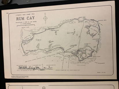
Sold2021Boating maps, rum cay, conception island, San Salvador.Maps from 1981 tropic Isle publishers, Inc By Harry Kline, Rum Cay, Conception island, San Salvador. Size 11“ x 17“See Sold Price
Sold2021Boating Maps, Elizabeth Harbor, Pike Creek, ElizabethMaps from 1981 tropic Isle publishers inc, by Harry Klein, Elizabeth Harbor, pipe Creek, Elizabeth Harbor to hog Cay, size 11“ x 17“See Sold Price
Sold2021Boating Maps, Long Island, Long Island north end, eastMaps from 1981 tropic Isle publishers, Inc. by Harry Klein, Long Island, Long Island Northwynn, East Coast harbors. Size, 11” x17”See Sold Price
Sold2016Rare, 1890s Map of MaineRare map of Maine, “Freeport Sheet†by the US Geological survey from 1890. Shows islands and necks within Casco Bay as well as Freeport, Cumberland, Brunswick and surrounding towns. Matted aSee Sold Price
Sold2021Boating maps, crooked island district, little SanMaps from 1981 tropic Isle publishers, Inc By Harry Kline, Crooked island district, little San Salvador little island or little cat island, cat island and little San Salvador. Size 11“ x 17̶See Sold Price
Sold2021Boating Maps, Brock cay to channel cay, bitter guanaMaps from 1981 tropic Isle publishers, Inc, by Harry Kline, Brock Cay to Channel Cay, Bitter Guana Cay to Brock Cay, Bimini Cat Cay. size, 11“ x 17“See Sold Price
Sold2021Boating maps, Southern Berry islands, Central BerryMaps from 1981 tropic Isle publishers, Inc By Harry Kline, Southern Berry Islands, Central Berry islands, Northern Berry islands. Size 11“ x 17“See Sold Price
Sold2021Boating Maps, central Bahamas, farmers cay galliot cutMaps from 1981 tropic Isle publishers, Inc by Harry Klein, Central Bahamas, farmers Cay galliot cut, size 11“ x 17“See Sold Price
Sold2021Boating Maps, Bahamas for out islands, The BahamaMaps from 1981 tropic Isle publishers, Inc By Harry Klein, Bahamas far out islands, The Bahama Islands, airstrip locations.See Sold Price
Sold2017Spanish Canary Islands Map, Bellin, 1746Carte des Isles Canaries Map. Bellin's beautifully designed map of the Spanish Canary Islands, "drawn from the journals of navigators," with a dramatic compass rose in the center and a decorative foliSee Sold Price
Sold2019Bellin: Canary IslandsBellin's beautifully designed map of the Spanish Canary Islands, "drawn from the journals of navigators," with a dramatic compass rose in the center and a decorative foliage cartouche, from the atlasSee Sold Price
Sold2021Boating maps, western New Providence, rose island,Maps from 1981 tropic Isle publishers, Inc By Harry Kline, Western New Providence, rose Island, eastern approaches to Nassau harbour. Size 11“ x 17“See Sold Price
Sold2021Boating Maps, hub of Abaco, man-of-war cay to CherokeeMaps from 1981 tropic Isle publishers, Inc By Harry Kline hub of Abaco, man-of-war cay to. Cherokee sound, marsh Harbour size 11“ x 17“See Sold Price
Sold2021Boating Maps, sail rocks to cistern cay, spaniel cay,Maps from 1981 tropic Isle publishers, Inc By Harry Kline, sale rocks to cistern Cay, staniel cay, allans cay harbour. Size 11“ x 17“See Sold Price
Sold2021A Large Pair Of Carved Marble Lions.Good large size and well executed. From a Roslyn Harbor Long Island NY estate. (approx 30 years old). - Dimensions: 43" x 36"See Sold Price
Sold2017Mitchell: Antique Map of Palestine, 18481861 Johnson’s China. Lovely map of China with original hand coloring. Features two insets: Harbor & Island of Amoy, and Map of Canton and Adjacent Islands. Very clean with good impression. From theSee Sold Price
Sold2017Bellin: Map of Mexico City & Lake Texcoco, 1758Map Title: 'Carte du Lac de Mexique, et de ses Environs. Lors de le Conqueste des Espagnols Pour servir à l'Histoire Générale des Voyages' A map of Spanish colonial Mexico City on an island in LakeSee Sold Price
Sold2021Boating maps, The brights of intros, Stafford Creek toMaps from 1981 tropic Isle publishers, Inc By Harry Kline, The brights of andros, Stafford Creek to North bright, jousters cays to Stanford creek. Size 11“ x 17“See Sold Price
4 days LeftJasper52Bay Ridge, Red Hook and Buttermilk Channels. Gowanus Creek Channel. Channel Between the Battery andUS$75
5 days LeftJasper52Islands in the Pacific Ocean. Hawaii. Phantom Jardines islands. THOMSON 1830 mapUS$75
BonhamsSHOBERL (FREDERIC) The World in Miniature, FIRST EDITION, COMPLETE IN 43 VOLUMES, R. Ackerman, [...£3,000(1 bid)
4 days LeftJasper521760 MAP CARTE PARTICULIERE DE L'ISLE DE JUAN FERNANDES antique Robinson CrusoeUS$55
Jun 23Schilb Antiquarian Rare BooksUS War w/ SPAIN 1898 1ed Puerto Rico CUBA Philippines MAPS Russell IllustratedUS$185(4 bids)
BonhamsBLAEU (WILLEM AND JAN) Toonneel des Aerdrycz, oft Nieuwe Atlas... Tweede Deels, 2 parts in 1 vol...£8,000
4 days LeftWilliam Bunch Auctions & AppraisalsFrancesc Coradal Cugat "Bridgetown Harbor, Barbados"US$200
Jun 23East Coast Fine Arts LLCFrederick J Sykes 24x51 1882 Hudson River School Castle Brooklyn Harbor NYUS$6,000
Jun 23Schilb Antiquarian Rare Books1855 San Francisco 1st ed California Gold Rush Illustrated MAPS Soule IndiansUS$13(4 bids)
1 day LeftCrescent City Auction GalleryPair of New Orleans Sanborn Fire Insurance Mock-Up Skeleton Maps of the French Quarter, 1910-1911,US$250
6 days LeftFreeman's | HindmanMiquel Barceló (Spanish, b. 1957) Nature Morte à la Grappe de RaisinUS$10,000
6 days LeftFreeman's | HindmanMiquel Barceló (Spanish, b. 1957) Yellow Abstraction, 1994US$15,000
BonhamsBRADFORD (WILLIAM) Sketches of the Country, Character, and Costume in Portugal and Spain Made Du...£500


![[Maps & Atlases] Speed, John: Spaine (1 of 2)](https://p1.liveauctioneers.com/65/332523/179335175_1_x.jpg?height=282&quality=70&version=1717709446)


![[FOLK ART PAINTING] (American, 19th century). Elsie Nearing... (1 of 1)](https://p1.liveauctioneers.com/928/330686/178765500_1_x.jpg?height=282&quality=70&version=1716992685)


![[Maps & Atlases] Seutter, Matth(ias).: Novus Orbis sive America... (1 of 2)](https://p1.liveauctioneers.com/65/332523/179335174_1_x.jpg?height=282&quality=70&version=1717709447)


