Sold20211642 Blaeu Map of the Belgian-Dutch-German Border AreaTitle: 1642 Blaeu Map of the Belgian-Dutch-German Border Area -- Ducatus Limburgum Auctore Aegidio Martini Cartographer: J Blaeu Year/Place: c1642; Amsterdam Dimensions: 15x19.5 in. Description: ThisSee Sold Price
Sold20231635 Engraved Map of BlaeuA map attributed to Joan Blaeu, Dutch Cartographer (1596-1673) of the area Leodiensus Dioecesis circa 1635. Measures 5.5 x 5". Reserve: $30.00 Shipping: Domestic: Flat-rate of $8.00 to anywhere withinSee Sold Price
Sold2024Willen Janszoon Blaeu, Scotia Regnum(Dutch, 1571-1638) Hand colored engraved map of Scotland, c. 1642. Framed double sided with book text on verso. Sight: 16-1/2"h x 21-1/4"w Overall: 26"h x 30-3/4"w Provenance: Paulus Swaen, Inc. IndiaSee Sold Price
Sold2019Wilem J. Blaeu mapWilem J. Blaeu (Dutch 1571-1638)- Americae Nova Tabula- engraved map with hand-coloring, ca. 1633. 16 1/4 x 21 1/2''See Sold Price
Sold2018(1635) Blaeu Map: Mappa Aestivarvm Insularum,...Historic Maps Hand-Colored "Mappa Aestivarvm Insularum, alias Barmvdas dictarum..." by Willem J. Blaeu, Amsterdam (1635) Hand-Colored Historic Dutch Map titled: "Mappa Aestivarvm Insularum, alias BarmSee Sold Price
Sold2022Abraham Ortelius and Theodore de Bry, Two Vintage MapsABRAHAM ORTELIUS and THEODORE DE BRY (Belgian, 1527-1598), (German, 1528 - 1598), Maris Pacifici quod vulgo Mar del Zud, 1601, and Hispaniae Novae Sive Magnae, Recens et Vera Descriptio, 1595, two vinSee Sold Price
Sold2022Abraham Ortelius and Jacob Van Meurs, Two Vintage MapsABRAHAM ORTELIUS and JACOBUS VAN MEURS (Belgian, 1527-1598), (Dutch, 1760-1824), Tartariae Sive Magni Chami Regni typus, circa 1609 AND Novissima et Accuratissima Totius Americae Descriptio per JacobuSee Sold Price
Sold2021MAP, Western Hemisphere, BlaeuBlaeu's Stunning Carte-a-Figures Map of the Americas in Full Contemporary Color. Western Hemisphere - America. Willem Blaeu, Americae Nova Tabula, 1642 (circa). Hand Color. This stunning carte-a-figurSee Sold Price
Sold2023BLAEU, Willem (1571-1638) -- BLAEU, Jan (1596-1673). Americae nova Tabula. [Amsterdam, ca 1635 orBLAEU, Willem (1571-1638) -- BLAEU, Jan (1596-1673). Americae nova Tabula. [Amsterdam, ca 1635 or later]. Engraved map of the Americas, visible area 17 x 21 3/4 in. (432 x 552 mm). Framed (unexaminedSee Sold Price
Sold2024Blaeu's Tooneel des Aerdrycx - Fifth Volume with 55 Engraved MapsThis remarkable fifth volume of 55 maps with original hand-coloring is is Jan & Willem Blaeu's Tooneel des Aerdrycx, oft Nieuwe Atlas ? Vyfde Deel or Theatrum Orbis Terrarum, Dutch edition. This was pSee Sold Price
Sold2024Willem Blaeu, Map of The AmericasAmsterdam, 1617. Together with "Early Maps" by Tony Campbell, Abbeville Press and "The United States in Old Maps and Prints, Eduard Van Ermen. 3 pieces Sight size: 16-1/2"h x 22"w Overall: 23-1/2"h xSee Sold Price
Sold2017HENDRIK LOT (DUTCH-GERMAN 1821-1878)HENDRIK LOT (DUTCH-GERMAN 1821-1878) Grazing Sheep, oil on canvas 63 x 94.5 cm (24 3/4 x 37 1/4 in.) signed lower left LOT NOTES Hendrik Lot, also known as Henry Lot, was a a celebrated landscape painSee Sold Price
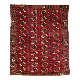
Sold2019Tekke Main CarpetMid 19th century, 210 x 180 cm, Central Asia, West Turkestan A Tekke main carpet with four x eleven primary güls, kurbaghe secondary motifs and a densely patterned border area. Extraordinarily fine iSee Sold Price
Sold2017USHAK CARPET - 9' x 13'West Anatolia, early 20th c., staggered large medallions in aubergine, royal blue, beige, goldenrod and red set on a coral field, matching coral palmette border. Areas of wear, end loss, three large hSee Sold Price
Sold2018Blaeu: Landmark Map of the AmericasCartographer: Willem Blaeu Place/Date: Amsterdam / 1617/1665 Size: 21 1/2" x 16 1/2" Condition: contemporary color; minor spotting, a few small printer's creases at sides of image. Some waterstainingSee Sold Price
Sold2017European Flemish Tapestry wool 17th century BelgianEuropean Flemish Tapestry wool 17th century, Belgian or Dutch; Size: Approximately 7 x 8 feet = 210 cm x 240 cm; Condition: used, several repairs, refer to the photos, please; Low Estimate: 20000; HigSee Sold Price
Sold2019Willy Schlobach (1865 - 1951) Port of HamburgWilly Schlobach (Belgium, 1865 - 1951) Painting of the Port of Hamburg, Germany. Signed monogram and dated 1928 lower left. Oil on Canvas. Willy Schlobach was a German-Belgian painter. He was a foundiSee Sold Price
Sold2022Johann Georg Schuz(German, 1755-1813) View of the Rhine River, signed lower right "Schuz. fecit", oil on canvas, 16-3/8 x 20-1/4 in.; 17th century Dutch or German, reverse profile ripple molding frame, 26-3/4 x 31-1/2See Sold Price
Sold202418th C. German Hand Carved Wood Chest Box or Trunk18th Century German - Dutch hand carved wood chest box or trunk with iron mounts Hand carved floral designs throughout the exterior and lid. Iron hardware including the handle, the hinges, locking mecSee Sold Price
Sold2022A German or Dutch late 18th century mahogany, purpleheart, ebony, plum, fruitwood and stained sy...A German or Dutch late 18th century mahogany, purpleheart, ebony, plum, fruitwood and stained sycamore marquetry tric trac or games table 1775-1790 The detachable quarter veneered top with rounded earSee Sold Price
SoldWW1 German 1917 Map of BelgiumWW1 German 1917 Map of Belgium, interesting map of a scale 1:100,000, produced for the German 4th Army (4.Armee). Marked to the top “Geheim” meaning secret. Map shows the positions of theSee Sold Price
Sold2018ATTRIBUTED TO WILLEN BLAEU 2 ENGRAVED MAPSATTRIBUTED TO WILLEN BLAEU, 2 HAND COLORED ENGRAVED MAPS, "NAVA BELGICA" & "MAPPA AESTIVARUM", 15 1/4" X 19 3/4" & 16" X 21" DATES OF PRINTING ARE UNKNOWN; FRAMED. ARNOLD KLEIN FRAMING LABEL.See Sold Price
Sold2022100 16th century Leaves with WoodcutsHeading: Author: Geisberg, Max Title: Woodcuts From Books of the 16th Century From German / Swiss / Dutch / French / Spanish And Italian Presses Place Published: Olten Publisher:Weiss-Hesse AntiquariSee Sold Price
Sold2020Oriental (Heriz) Carpet - 9' 4" X 12' 4"All over geometric and floral design with deep blue border, worn. Small area re-woven.See Sold Price
BonhamsBLAEU (WILLEM AND JAN) Toonneel des Aerdrycz, oft Nieuwe Atlas... Tweede Deels, 2 parts in 1 vol...£8,000
Featured19 hrs LeftJasper521640 Blaeu Map of Central France with Clemont-Ferrand as Center -- AuvergneUS$150
Jun 15Riverfront Auctions'Montium recuperation, Albano Gubernatore' (1572 CE) by Johann Wilhelm BaurUS$100
3 days LeftFreeman's | Hindman[MAP]. TODESCHI, Pietro. [Nova et Acurata Totius Americae Tabula auct. G.I. Blaeu] America quartaUS$5,000
7 days LeftWinter Associates Three early brass boxes, Dutch, 18th C. or later, details include: tobacco box with Asian-inspiredUS$75
6 days LeftThe North Georgia Auction Company LLCClint Alderman Edgefield Area Potteries MapUS$200(1 bid)
2 days LeftRapid Estate Liquidators and Auction Gallery1910 USGS Topographic Map of Iowa-IllinoisUS$5(1 bid)


![BLAEU, Willem (1571-1638) -- BLAEU, Jan (1596-1673). Americae nova Tabula. [Amsterdam, ca 1635 or: BLAEU, Willem (1571-1638) -- BLAEU, Jan (1596-1673). Americae nova Tabula. [Amsterdam, ca 1635 or later]. Engraved map of the Americas, visible area 17 x 21 3/4 in. (432 x 552 mm). Framed (unexamined](https://p1.liveauctioneers.com/197/305445/163194205_1_x.jpg?height=310&quality=70&version=1697056857)


![[MAP]. TODESCHI, Pietro. [Nova et Acurata Totius Americae Tabula auct. G.I. Blaeu] America quarta (1 of 1)](https://p1.liveauctioneers.com/197/329395/177650542_1_x.jpg?height=282&quality=70&version=1715364962)


