Sold2021Michael Drayton Map for Poly-Olbion, 1612-1622**Originally Listed At $400** Michael Drayton (British, 1563-1631). Engraved by William Hole (British, d. 1624). Map of Gloucestershyre and Worcestershyre for "Poly-Olbion" ca. 1612-1622. A hand-colorSee Sold Price
Sold2024Pictorial Map of the Gulf CoastPictorial Map of the Gulf Coast, 1955, drawn by Walter Overton, published by Claude Bagge, sight 13 1/2 in. x 22 in., framed. Provenance: Michael W. Murphy, El Dorado, AR.See Sold Price
Sold2023A framed 17th century map of Tartary by HondiusA framed 17th century map of Tartary by Jodocus Hondius the Elder (1563-1612). This was first issued in 1606 and continued to be printed by Hondius wife and sons in the decades after the elder HondiusSee Sold Price
Sold2023Hondius Map of The AmericasHONDIUS, Jodocus (1563-1612). America. Engraved map with original hand color. Amsterdam, 1606, or later. 17 1/2” x 21 1/2” sheet, 29 1/2” x 33” framed. A striking map of the WeSee Sold Price
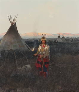
Sold2021Bev Doolittle "Pray for the Wild Things" SignedArtist: Bev Doolittle Title: Prayer for the Wild Things Medium: Lithograph Limited Edition: 40768/65000 Art Dimensions: 28 H x 21 W inches Framed Dimensions: 40 H x 32 WSee Sold Price
Sold2020Framed Map of ManhattanMap of Manhattan. [Map: 20" H x 50" W; Frame: 23 1/2" H x 53 1/2" W].See Sold Price
Sold2022FRAMED MAP OF HOUSTON TEXAS, RESTRIKE 1891FRAMED MAP OF HOUSTON TEXAS, RESTRIKE 1891. Height: 36 in. by Width: 56 in.See Sold Price
Sold2021Large Matted and Framed Map of Norfolk Virginia:Large Matted and Framed Map of Norfolk Virginia: Stylized Blazon Coat of Arms of Howard Duke of Norfolk (Premier Duke of England) Motto is "Virtuecont Alone is Invincible". Labeled JH DINGEE, Banker,See Sold Price
Sold2016Group of Nine Matching Framed MapsGroup lot of nine framed maps all with matching gilt frames with burgundy mat board and gilt inner frame and UV protective glass. including: Roma, Helvetia, Hereford shire, Persia, Asia, The World, PaSee Sold Price
Sold2022Two railroad framed maps:Nickel Plate - the New York, Chicago, St. Louis RR, 18"x34", AND Detroit United Railways Interurban Lines, 11"x34"See Sold Price
Sold2022Map of United States, JH Colton, ca 1849A framed map of the United States, Map of the United States of America, The British Provinces, Mexico, the West Indies and Central America with part of New Granada and Venezuela by JH Colton, ca 1849,See Sold Price
Sold2023Original 1931 Chicago Gangland Map - FramedOriginal 1931 Chicago Gangland Map - Framed. As best as we can tell, this is an original from 1931. It measures roughly 28.5" x 22 7/8" without the frame. This a great historical Chicago piece! ThereSee Sold Price
Sold2017FRAMED WORLD MAP BY HERMAN MOLL, 1719'A New & Correct Map of the Whole World, by Herman Moll, Geographer, 1719.' Hand tinted and framed. Frame size: 73 x 124 cm (28 3/4 x 48 3/4 in.)See Sold Price
Sold2023Antique Framed Wayfarer's Map of New York 1939Antique Framed Wayfarer's Map of New York 1939. Framed. Signed by Charles D. Graves, possibly the map maker. Copyrighted 1939, Herbert C. Wyman, Pleasantville, NY. Wayfarer's Maps.See Sold Price
Sold2022Framed Chinese Map of China and Korea, 19th CenturyA framed Chinese watercolor and ink map on paper of China and Korea dating from the 19th century. It is mounted on a silk backing. Dimensions are: 10 1/2 inches tall X 13 inches wide, 26.7 cm X 33 cm,See Sold Price
Sold2022MAIER, MICHAEL. 1568-1622. Viatorium hoc est de Montibus Planetarum Septem seu Metallorum. Oppen...MAIER, MICHAEL. 1568-1622. Viatorium hoc est de Montibus Planetarum Septem seu Metallorum. Oppenheim: Hieronymus Galler, 1618. 4to (191 x 163 mm). Title page with woodcut borders, 7 woodcut illustratiSee Sold Price
Sold2021Michael Coleman Last Light, 1981Michael Coleman (American, b. 1946) Last Light, 1981 Oil on board 16 x 14 (in) 22.25 x 20.25 x 2 (in) Framed Signed Michael Coleman, lower right Titled and dated on artist's tag, verso. Altermann ArtSee Sold Price
Sold2018Moshe Kupferman (1926-2003) IsraeliSTRUCTURES, oil painting on canvas, signed lower left, 22 ¾ x 31 ¾”, framed. Provenance: Michael Hittleman Gallery Los Angeles.See Sold Price
Sold2024Matthaus Merian 1627 Antique Hand Colored Map "Virginia" from Theodore de Bry's "Grand Voyages" #2Antique 1627 hand-colored map of Virginia by Matthaus Merian after John Smith's 1612 map, from Theodore de Bry's "Grand Voyages". Good condition overall, with age-appropriate wear, repairs (see photosSee Sold Price
Sold2024Matthaus Merian 1627 Antique Map Engraving "Virginia" from Theodore de Bry's "Grand Voyages" #1Antique 1627 map of Virginia by Matthaus Merian after John Smith's 1612 map, from Theodore de Bry's "Grand Voyages". Please see "The Philidelphia Print Shop" sheet shown in final photo. Good conditionSee Sold Price
Sold2018Samuel Bak (b. 1933) AmericanA PEAR IN THE LANDSCAPE, oil painting on canvas, signed lower left, 11 x 9”, framed. Provenance: Michael Hittleman Gallery Los Angeles.See Sold Price
Sold2024Emanuel Sweert (1552-1612)[FLORAL STUDIES] Four hand-colored engravings, from Florilegium amplissimum et selectissimum, Amsterdam, 1612, framed.Sight of each 12 3/4 x 8 3/8 inches; 324 x 213 mm.Largest frame 24 1/4 x 19 3/4 inSee Sold Price
Sold2016Lithographed Map of Oregon, 1866Oregon. U.S. General Land Office. hand-colored Lithograph. New York: Major & Knapp, c. 1866. 17 1/2 x 23 inches sheet, 27 x 32 1/2 inches framed. This map shows the state of Oregon seven years after sSee Sold Price
Sold20241864 Map of Virginiaprinted at the Coast Survey Office. A.D. Bache Supdt. Civil War era railroad map. Framed and under glass. Overall size is 27" x 41" Map has some creases from being folded and stains.See Sold Price
Jul 11Dan Morphy AuctionsRARE INDEPENDENT GASOLINE & MOTOR OIL FRAMED GRAPHIC HIGHWAY MAP OF ILLINOIS.US$125
1 day LeftDOYLE Auctioneers & AppraisersAn eighteenth-century map of Nîmes in Southern France, with views of its Roman monumentsUS$100(1 bid)
2 days LeftMynt AuctionsMichael Jordan Autographed 20X46 Framed Photo "The Show" The Last Shot BullsUS$235(3 bids)
1 day LeftDOYLE Auctioneers & AppraisersAn attractive eighteenth-century Dutch map of the AmericasUS$150
5 days LeftGeorge Cole AuctionsLot 2 Framed Hand Colored Engr 18th C Map Of India + Environs 6" X 8 1/4" + Poughkeepsie 3 3/4" X 7US$30
5 days LeftMichael's GalleryMilford Zornes (Untitled - Landscape) Original Signed Watercolor - 1968US$550


![Framed Map of Manhattan: Map of Manhattan. [Map: 20" H x 50" W; Frame: 23 1/2" H x 53 1/2" W].](https://p1.liveauctioneers.com/1221/185484/93762114_1_x.jpg?height=310&quality=70&version=1606596560)


![Emanuel Sweert (1552-1612): [FLORAL STUDIES] Four hand-colored engravings, from Florilegium amplissimum et selectissimum, Amsterdam, 1612, framed.Sight of each 12 3/4 x 8 3/8 inches; 324 x 213 mm.Largest frame 24 1/4 x 19 3/4 in](https://p1.liveauctioneers.com/292/313892/168352433_1_x.jpg?height=310&quality=70&version=1704304802)


