Sold2021Astronomical chart on eclipse’s , 1780, by J. deTitle: Astronomical chart on eclipse’s , 1780, by J. de la Porte, Paris Date/Period: 1780 Materials: Hand colored copperplate engraved Size: 9x7'' 1780. By Joesph de La Porte. From. ‘AtlasSee Sold Price
Sold2015Pair of Baroque Astronomical Charts, Johann ZahnPair of 17th century hand colored, copper plate engraved Baroque astronomical charts by Johann or Johannes Zahn (1641-1707), "Three Competing Views of the Universe: the Ptolemaic earth-centered view;See Sold Price
Sold2019Science & Tech C1750-1823 Lot of 6 PrintsIncl Latitude/Lenses, Astronomical Instruments, Sound, Crystallization, Chart Showing Deaths, Strata of the Crust of the Earth. Examples by Phillips, Linnaeus/Sibly, Jeffery's, and Rees. Paper Size: USee Sold Price
Sold2021Armillary sphere and astronomical 1780, by J. de laTitle: Armillary sphere and astronomical 1780, by J. de la Porte, Paris Date/Period: 1780 Materials: Hand colored copperplate engraved Size: 9x7'' 1780. By Joesph de La Porte. From. ‘Atlas ModerSee Sold Price
Sold2016Astronomical Chart of Refraction, 1891Original engraving from "The Cosmographic Atlas" by W. & A. K. Johnston, London, 1891. Custom framed in UV protectant glass. Dimensions: 18" L x 1" W x 15.5" H This item ships from Ocean View, DE.See Sold Price
Sold2022Antique Astronomical Map - Northern & Southern Hemispheres - John BartholomewAntique Astronomical Map "Northern & Southern Hemispheres" by John Bartholomew. Old Constellation Astronomy Chart. Astronomical charts, star charts, lithographs of the planets, the Moon, the solar sysSee Sold Price
Sold20211883 The Stars NAVIGATION Nautical Astronomy Compass1883 The Stars NAVIGATION Nautical Astronomy Compass Rosser Illustrated MAPS ‘How to find the Stars’ is a practical guide for navigation utilizing the sky and astronomical charts to find longitudeSee Sold Price
Sold2021Cram's Unrivaled Atlas of the World [131661]Maps of the continents, countries, colonies, plus all geographical and political divisions of the world. Also contains astronomical charts, diagrams, maps and descriptive matter. There are ancient claSee Sold Price
Sold2017Doppelmayr / Homann: Celestial Chart of Earth's OrbitsMap: 1742 Doppelmayr / Homann Celestial Cart of the Orbits of Earth, Venus and Mercury -- Phaenomena Motuum Irregularium quos Planetae inferiores Venus et Mercurius ad annum Salutis MDCCX Date/Place:See Sold Price
Sold2023Blackie (Pub) C1875 Astronomy Celestial Chart. The Earth, Seasons, CometsLithograph Map Published 1837-1893 by Blackie & Son, London for "The Popular Encyclopedia; or, Conversations Lexicon" Centre fold as issued. Paper Size: 12.5 x 9.5 inch (30 x 24cm) Very minor toning,See Sold Price
Sold20191834 British Nautical Almanac Astronomical Ephemeris1834 British Nautical Almanac Astronomical Ephemeris Charts Planets PROVENANCE An extremely rare early 19th-century nautical almanac of the Lords Commissioners of the Admiralty for the years 1836 andSee Sold Price
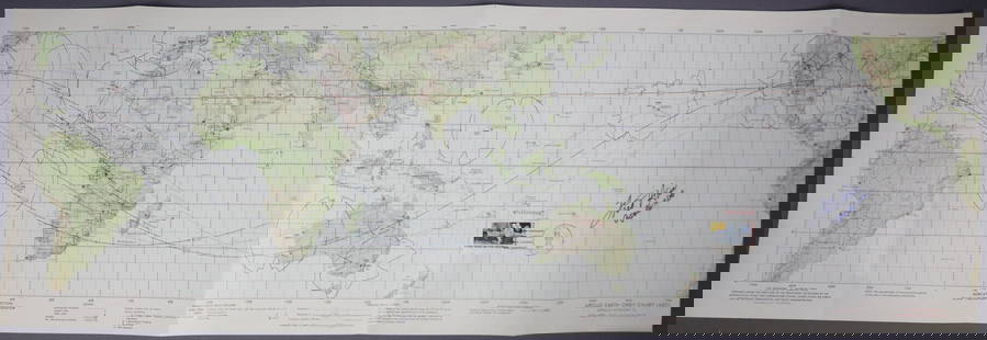
Sold2019Apollo 16 Earth Orbit Chart in Color.This original earth orbit chart dated February 15th 1972 for the Apollo 16 mission measures 13 1/2 inches tall by 41 inches long. Depicts earth revolutions one and two, the trans lunar injection burn,See Sold Price
Sold2023Fred Haise Signed Apollo 13 Earth Orbit ChartFirst Edition Apollo 13 Earth Orbit Chart measuring 41 1/2" x 13 1/2" that was prepared for NASA under the direction of the Department of Defense by the Aeronautical Chart and Information Center and dSee Sold Price
Sold2023Lunar Earth Side Chart LEC-1A beautiful Lunar Earth Side Chart LEC-1. This provisional chart is dated July 1968 and is compiled from the Lunar Orbiter 3 & 4 high resolution photographs. This is a very early and detailed LunaSee Sold Price
Sold20211960 Denoyer Geppert Science 12 Charts History of EarthDenoyer – Geppert picture History of Earth . There are twelve Science Charts in this series 1-Earth , 2- Earth as a sphere , 3- relationship of Earth and Sun , 4 - Maps , 5 - Time , 6 - Inside ESee Sold Price
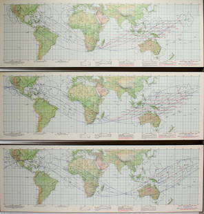
Sold20193 NASA APOLLO EARTH ORBIT CHARTS3 NASA APOLLO EARTH ORBIT CHARTS: 1st edition 26 November 1968. Prepared under the direction of the Department of Defense for NASA. Lithographed by ACIC 11/68. 41 1/2" XSee Sold Price
Sold2018Bonne: Antique Map of South America, 1780TITLE/CONTENT OF MAP: 'Amerique Méridionale' A map of South America. old antique map plan chart DATE PRINTED: 1780 IMAGE SIZE: Approx 34.5 x 22.5cm, 13.5 x 9 inches (Large); Please note that this isSee Sold Price
Sold2020Gemini GT-11 Mission Tracking ChartGemini mission GT-11 Earth Tracking Chart. This original and full sized map measures 11" x 32". The map is dated August 1966 and has the tracking coordinates on the back. This map has always been foldSee Sold Price
Sold2023Apollo 10 Earth Orbit Tracking ChartA vintage and original Apollo 10 Earth Orbit Tracking Chart from NASA. This is a First Edition sheet 2 of 3 and dated 16 April 1969. It measures 13 1/2" x 41 1/2" and is in very good condition with miSee Sold Price
Sold2023Apollo 9 Earth Orbit Tracking ChartAn original Apollo 9 Earth Orbit Tracking Chart. This first edition chart dated January 31, 1969 measures 13 ½” x 41 ½” and is in very good condition with light edge wear. This cSee Sold Price
Sold2022A FIRST EDITION COPY OF ASTRONOMICAL ATLAS' MAPS AND CHARTS by Basil Brown published 1932.A FIRST EDITION COPY OF ASTRONOMICAL ATLAS' MAPS AND CHARTS by Basil Brown published 1932.See Sold Price
Sold2023Neil, Samuel 1897 Astronomy Chart. Revolution of the Earth round the SunWoodblock Published 1897, London for "The Home Teacher. A Cyclopededia of Self Instruction" Edited by Samuel Neil. Centre fold as published. Paper Size: 14 x 10.5 inch (36 x 27cm) Good ConditionSee Sold Price
Sold201512 engravings by Ferguson after Mynde: astronomy.[Astronomy] 12 engravings consisting of astronomical diagrams, including the rotation and revolution of planets and the concept of an elliptical. Plates IV, VII, VIII, and XIII relate to an orrery. FoSee Sold Price
Sold2020Group of Astrology Antiquarian Books & Ephemera.Group of Antiquarian books and ephemera relating to Astronomy & Uranology. Astronomical Atlases, Maps and Charts by Basil Brown; Treatise on Astronomy by John F. W. Herschell; Atlas of the Heavens bySee Sold Price
5 days LeftTrillium Antique Prints & Rare BooksCaptain Cook, Large Folio - Chart of the New Coast of America and New Coast of AsiaUS$100
5 days LeftTrillium Antique Prints & Rare BooksCaptain Cook, Large Folio - A General Chart: Exhibiting the Discoveries made by Captain James CookUS$200
10 hrs LeftHudson Valley Auctioneers LLC Beacon NYD. J. Gale's Astronomical Calendar, wall clock, painted zinc dial, rosewood veneer case, withUS$3,250(11 bids)
Jun 25Freeman's | Hindman[Maps & Atlases] Oliva, Joan: Portolan Chart of the MediterraneanUS$10,000(1 bid)
Jul 14Schilb Antiquarian Rare Books1780 Voyages in KAMCHATKA Jan Mayen Island Russia Greenland Nova Zembla NunavutUS$1(1 bid)
Jul 14Schilb Antiquarian Rare Books1780 Voyages in CARIBBEAN Antilles Jamaica Barbados Dominican Magellan Drake 2vUS$1


![Cram's Unrivaled Atlas of the World [131661]: Maps of the continents, countries, colonies, plus all geographical and political divisions of the world. Also contains astronomical charts, diagrams, maps and descriptive matter. There are ancient cla](https://p1.liveauctioneers.com/2699/202326/102449349_1_x.jpg?height=310&quality=70&version=1619652794)


![12 engravings by Ferguson after Mynde: astronomy.: [Astronomy] 12 engravings consisting of astronomical diagrams, including the rotation and revolution of planets and the concept of an elliptical. Plates IV, VII, VIII, and XIII relate to an orrery. Fo](https://p1.liveauctioneers.com/179/82189/42600000_1_x.jpg?height=310&quality=70&version=1447864785)


![[Maps & Atlases] Oliva, Joan: Portolan Chart of the Mediterranean (1 of 2)](https://p1.liveauctioneers.com/65/332523/179335172_1_x.jpg?height=282&quality=70&version=1717709445)

![[MATH] LIBURNENSIS: OPUSCULA ANALYTICA. 1780 (1 of 3)](https://p1.liveauctioneers.com/8124/333020/179782298_1_x.jpg?height=282&quality=70&version=1718226059)


