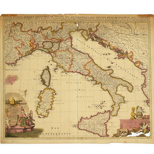
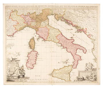
Sold2022Nicolas Sansom, map of Italy, 1701Nicolas Sansom, map of Italy, 1701, "L'Italie Divisee Suivant l'Estendue de Toutes ses Sourverainetes…", Pieter Schenk, Amsterdam, 1701, hand-colored copper plate engraving on laid paper, 20.25"See Sold Price
Sold2021Nicolas Sansom, map of Italy, 1701Nicolas Sansom, map of Italy, 1701, "L'Italie Divisee Suivant l'Estendue de Toutes ses Sourverainetes…", Pieter Schenk, Amsterdam, 1701, hand-colored copper plate engraving on laid paper, 20.25"See Sold Price
Sold2019Sanson map of Italy 1701Heading: Author: Sanson, Nicolas Title: L'Italie Divisee Suivant l'Estendue de Toutes ses Sourverainetes... Place Published: Amsterdam Publisher:Pieter Schenk Date Published: 1701 DescSee Sold Price
Sold2023Scarce and fine 1701 1st ed. map of Italy by Herman MollExcellent example of Moll’s 1701 map of Italy from the first edition of “A System of Geography.” A very scarce map with expertly applied modern full hand coloring according to politSee Sold Price
Sold2022Ancient Roman Republic era Italy. 1701-1706 by Christoph CellariusTitle: Ancient Roman Republic era Italy. 1701-1706 by Christoph Cellarius Date/Period: 1701-1706 Materials: Copperplate engraved Size: 13x9" The ancient Italy shown on this map is pre imperial. ProminSee Sold Price
Sold2021De Fer Map of Italy, 1705[Europe, Italy] DE FER, Nicolas (1646-1720). Routes des Postes D'Italie... Engraved map with full original color and minor manuscript annotations. Paris, c. 1705. 19" x 27" sheet. This unusual, largeSee Sold Price
Sold2024Bonne & Desmarest - 4 Maps of Italy or surrounding IslandsThis fine map engraving is from Rigobert Bonne and Nicolas Desmarest's Atlas encyclop?dique, contenant la g?ographie ancienne, et quelques cartes sur la g?ographie du moyen age, la g?ographie moderneSee Sold Price
Sold2023Fontaine History of the New and Old TestamentFontaine, Nicolas. "History of the New and Old Testament" Second Edition, enlarged. Illustrated with 240 engraved images and 5 maps. London; R. Blome, et al, 1701. Full paneled calf with raised bandsSee Sold Price
Sold2023MAP, Alps, SansonAlps - Italy, Switzerland, Austria. Nicolas Sanson, Le Tirol, souz le Nom Duquel s'Entendent le Comte de Tirol; puis les Comtes de Bregentz, Feldkirck, Montfort, Pludentz, &c. Sujets..., from Cartes GSee Sold Price
Sold2017[Illustration, Bible History, De Royaumont, 1701]Fontaine, Nicolas, Sieur De Royaumont. THE HISTORY OF THE OLD AND NEW TESTAMENT… THE WHOLE ILLUSTRATED WITH TWO HUNDRED AND FORTY SCULPTURES AND FIVE SCRIPTURAL MAPS. Folio (16.25" x 10".) [10], 212See Sold Price
Sold2016Antiquarian Map - ItalyAntiquarian Map - Italy. Frame 20"x25", Sight 14.25"x19.25". Framed under glassSee Sold Price
Sold2019Barclay, James 1809 Antique Map. Italy"Italy divided into its Kingdoms States. &c" Outline Hand Coloured Copper Engraved Map Published 1809, Leeds for "Barclay's Complete and Universal Dictionary of the English Language..." by the Rev. JaSee Sold Price
Sold2022Barclay & Becker C1845 Map. ItalySteel Engraved Map Published C1845, London for "A Complete and Universal English Dictionary" by the Rev. James Barclay and B. B. Woodward. Maps by F. P. Becker. Outline hand colour. Paper Size: 10.5 xSee Sold Price
Sold2022Barclay, James C1800 Hand Col Map. ItalyHand Colored Copper Engraved Map Published C1800 Halifax & Newcastle, England for "Barclay's Universal English Dictionary…" by James Barclay. Maps Engraved by Clerk, Milton and others. Paper Size: 1See Sold Price
Sold2024Russell & Allen (Pub) 1812 Map. ItalyFolio Copper Engraved Map Published 1812 by Russell and Allen, Manchester for "A New And Commercial System Of Geography" Paper Size: 15.5 x 9 inch (39 x 23cm) Very minor toning. Good ConditionSee Sold Price
Sold2021Wilkes, John 1810 Map. ItalyCopper Engraved Map Published 1796-1828 London for "Encyclopaedia Londinensis, or universal dictionary of arts, sciences and literature" by John Wilkes et al. Paper Size: 10.5 x 8.5 inch (27 x 22cm) TSee Sold Price
Sold2022Barclay, James C1800 Hand Col Map. ItalyHand Colored Copper Engraved Map Published C1800 Halifax & Newcastle, England for "Barclay's Universal English Dictionary…" by James Barclay. Maps Engraved by Clerk, Milton and others. Paper Size: 1See Sold Price
Sold2022Guthrie & Kitchin 1782 Map. ItalyCopper Engraved Map Published 1782, London for "A New Geographical, Historical and Commercial Grammar..." by William Guthrie. The maps are by John Senex, Thomas Kitchin and others. Folds as issued. PaSee Sold Price
Sold2023Findlay, Alexander 1828 Map. ItalyCopper Engraved Map Published 1828, London for "The Oxford Encyclopaedia: Or, Dictionary of Arts, Sciences and General Literature" by Rev. W. Harris, J. A. Stewart, C. Butler, Rev. J. H. Hinton et al.See Sold Price
Sold2021Guthrie, William 1790 Antique Map. ItalyCopper Engraved Map Published 1790, London for "A New Geographical, Historical and Commercial Grammar..." by William Guthrie. The maps are by John Senex, Thomas Kitchin and others. Folds as issued. EaSee Sold Price
Sold2022Times Atlas 1895 Lot 7 Maps. Italy Switzerland AustriaLithograph Map Published 1895, London for "The Times Atlas" Two with Centre fold as published. Paper Size: Up to 21 x 16 inch (53 x 41cm) A few minor faults in parts. Good ConditionSee Sold Price
Sold2022Salmon & Jeffreys 1749 Map. ItalyCopper Engraved Map Published 1749, London for "A New Geographical and Historical Grammar" First or Early Edition by Thomas Salmon. Engraved by Thomas Jeffreys. Folds as issued. Paper Size: 10 x 8 incSee Sold Price
Sold2023Guthrie & Kitchin 1782 Antique Map. ItalyCopper Engraved Map Published 1782, London for "A New Geographical, Historical and Commercial Grammar..." by William Guthrie. The maps are by John Senex, Thomas Kitchin and others. Folds as issued. PaSee Sold Price
Sold2024Aitchison, Alexander 1799 Hand Col Map. ItalyOutline Hand Colored Copper Engraved Map Published 1798-99, London for "The Modern Gazetteer; Being a compendious Geographical Dictionary?" by Alexander Aitchison. Folds as issued. Paper Size: 10 x 10See Sold Price
5 days LeftJasper521641 MAP of ITALY antique authentic TERRITORIUM BONONIENSE IL BOLOGNESE originalUS$160
6 days LeftJasper52Colonial Africa. British German French Spanish Portuguese Italian TIMES 1900 mapUS$35
Featured6 days LeftJasper52Colonial Africa. British German French Spanish Portuguese Italian TIMES 1895 mapUS$40
5 days LeftJasper521581 Ortelius Map of Tuscany [with] Corsica [with] Ancona -- Senensis Ditionis, Accurata Descrip [onUS$140
6 days LeftJasper52COLONIAL AFRICA. British French German Italian Portugal Spain.STANFORD 1906 mapUS$15
Jun 07Freeman's | HindmanBELLIN, Jacques-Nicolas. Carte Reduite de L'Ocean Oriental ou Mer Des Indies. Paris, 1757. SecondUS$150
6 days LeftJasper52Plan du Portendic, appellé aussi…' Portendick Mauritania. BELLIN 1746 old mapUS$15


![De Fer Map of Italy, 1705: [Europe, Italy] DE FER, Nicolas (1646-1720). Routes des Postes D'Italie... Engraved map with full original color and minor manuscript annotations. Paris, c. 1705. 19" x 27" sheet. This unusual, large](https://p1.liveauctioneers.com/1968/216191/110783529_1_x.jpg?height=310&quality=70&version=1629990486)


![[Illustration, Bible History, De Royaumont, 1701]: Fontaine, Nicolas, Sieur De Royaumont. THE HISTORY OF THE OLD AND NEW TESTAMENT… THE WHOLE ILLUSTRATED WITH TWO HUNDRED AND FORTY SCULPTURES AND FIVE SCRIPTURAL MAPS. Folio (16.25" x 10".) [10], 212](https://p1.liveauctioneers.com/3532/111460/57224187_1_x.jpg?height=310&quality=70&version=1509131847)


![1581 Ortelius Map of Tuscany [with] Corsica [with] Ancona -- Senensis Ditionis, Accurata Descrip [on (1 of 1)](https://p1.liveauctioneers.com/5584/331064/178466435_1_x.jpg?height=282&quality=70&version=1716924723)


