Sold2023MAP, Alps, SansonAlps - Italy, Switzerland, Austria. Nicolas Sanson, Le Tirol, souz le Nom Duquel s'Entendent le Comte de Tirol; puis les Comtes de Bregentz, Feldkirck, Montfort, Pludentz, &c. Sujets..., from Cartes GSee Sold Price
Sold20181683 Sanson Map of the Great Lakes and the Upper EastTitle/Content of Map: 1683 Sanson Map of the Great Lakes and the Upper East Coast -- Le Canada, ou Nouvelle France, &c. Tiree de diverses Relations des Francois, Anglois, Hollandois, &c. Date: 1683, PSee Sold Price
Sold20211683 Sanson Map Great Lakes to Newfoundland -- LeTitle: 1683 Sanson Map Great Lakes to Newfoundland -- Le Canada, ou Nouvelle France, &c. Tiree de diverses Relations des Francois, Anglois, Hollandois, &c. Cartographer: N Sanson Year / Place: 1683 c.See Sold Price
Sold20181683 Sanson Map of the Great Lakes and the Upper EastTitle/Content of Map: 1683 Sanson Map of the Great Lakes and the Upper East Coast -- Le Canada, ou Nouvelle France, &c. Tiree de diverses Relations des Francois, Anglois, Hollandois, &c. Date Printed:See Sold Price
Sold20231652 Sanson Map of the World -- L'Hydrographie ou Descriprion de L'Eau c'est a dire des Mers,Title: 1652 Sanson Map of the World -- L'Hydrographie ou Descriprion de L'Eau c'est a dire des Mers, Golfes, Lacs, Destroits, et Rivieres principales, qui font dans la Surface du Globe Terrestre . . .See Sold Price
Sold2022Alexis Hubert Jaillot and Nicolas Sanson - Map of the Grand Duchy of Moscow, Etching, 1708.Alexis Hubert Jaillot (French, 1632-1712) and Nicolas Sanson (French, 1600-1667) - Map of the White Russia or the Grand Duchy of Moscow, Etching, 1708. Title: Les Estats du Czaar de Russie Blanche ouSee Sold Price
Sold2020Nicolas Sanson Map of AsiaNicolas Sanson (1600-1667) "L'Asie divisee en ses Principales Regions, et ou se peuvent voir l'estendue, Des Empires, Monarchies, Royaumes, et Estats," Paris: Jaillot, ca. 1719. Hand colored map of AsSee Sold Price
Sold2024Nicolas Sanson - Map of Asia / Asia divided into its Principal RegionsCopper engraving, 1600s/1700s, "Asia divided into its Principal Regions." By Mr. Sanson, Geographer Ordinary to the King. Size: 58 cm x 88 cm.See Sold Price
Sold2018RARE 17TH C. SANSON MAP OF LUXEMBOURGAlexis-Hubert Jaillot (c. 1632-1712); Nicolas Sanson (1600-1667) "Le Duche de Luxembourg Divise en Quarter Walon et Allemand....", hand colored engraving, published 1700 from earlier plates, Paris, frSee Sold Price
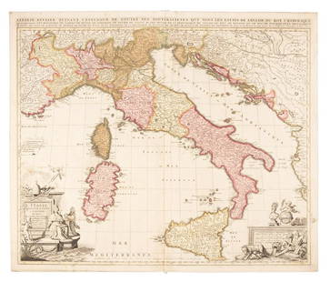
Sold2019Sanson map of Italy 1701Heading: Author: Sanson, Nicolas Title: L'Italie Divisee Suivant l'Estendue de Toutes ses Sourverainetes... Place Published: Amsterdam Publisher:Pieter Schenk Date Published: 1701 DescSee Sold Price
Sold2019MAP - Belarus. SansonBelarus. N. Sanson/Mariette, Partie de Lithuanie ou est le Palatinat de Nowogrodeck Litawiski, Subdivise en ses Chastellenies..., 1665 (dated). Hand Color. This map details much of present-day southweSee Sold Price
Sold20211652 Sanson Map of the Arabian Peninsula and the RedTitle: 1652 Sanson Map of the Arabian Peninsula and the Red Sea -- L'Arabie Petree, Deserte, et Heureuse Cartographer: N Sanson Year / Place: 1652, Paris Map Dimension (in.): 7.5 X 9.5 in. This is a rSee Sold Price
Sold2023Sanson map of ancient Asia 1650Heading: Author: Sanson, Nicolas Title: Asia Vetus Place Published: Paris Publisher: Date Published: [1650] Description: Copper-engraved map, hand-colored in outline; colored decorSee Sold Price
Sold20191700 c. Sanson Map of the Arabian Peninsula and the RedTitle/Content of Map: 1700 c. Sanson Map of the Arabian Peninsula and the Red Sea -- Arabia Petrea, Deserta et Felix Per N. Sanson Date: c. 1700 Cartographer: Based on N. Sanson Size: 7.5 X 9.5 in. ThSee Sold Price
Sold20231683 Sanson Map of South America -- Amerique MeridionaleTitle: 1683 Sanson Map of South America -- Amerique Meridionale Cartographer: N Sanson Year / Place: 1683, Paris Map Dimension (in.): 7.8 X 10/8 in. This is a superb map of South America with a charmiSee Sold Price
Sold2024MAP, Africa, SansonWestern Africa, Cape Verde Islands. Nicolas Sanson, D'Eilanden van Capo Verde, de Kust en't Landt der Negeren..., from Algemeene Weereld-Beschryving…, 1705 (published). Hand Color. This is an attracSee Sold Price
Sold2020Nicolas Sanson Map of Morea Greece 1692Nicolas Sanson (1600-1677), "La Moree et les Isles de Zante, Cafalonie, Ste Maure, Cerigo, &c." Paris: Hubert Jaillot, 1692. This hand-colored map depicts Morea, the southern part of Greece, with theSee Sold Price
Sold20191705 Sanson map of Russia w/huge marginsReserve Reduced! Beautiful specimen with modern hand coloring painstakingly applied. A strongly engraved map of European Russia showing its political divisions, major topographical features, cities anSee Sold Price
Sold20231700 Sanson Map of Sri Lanka and the Maldives -- Ceylan, et les MaldivesTitle/Content: 1700 Sanson Map of Sri Lanka and the Maldives -- Ceylan, et les Maldives Cartographer: N Sanson Year/Place: 1700, Paris Dimensions: 7.2 X 9.5 in. Description: This is an exquisite map oSee Sold Price
Sold2022MAP, Madagascar, SansonMadagascar. Nicolas Sanson, Isle de Madagascar ou de St. Laurens, Tiree de Sanut &c., from Geographise en Historise Werelt Beschryving, 1699 (circa). Black & White. Finely engraved, decorative map ofSee Sold Price
Sold2023Baedeker, Karl 1907 Lot of 65 Antique Maps. Eastern Alps. Germany Austria ItalyLithograph Maps Published 1907, Leipzig for "The Eastern Alps including The Bavarian Highlands, Tyrol, Salzburg, Upper and Lower Austria, Styria, Carinthia, and Carniola" by Karl Baedeker. Folds as isSee Sold Price
Sold2017Sanson: Antique Map of Americas with Atlantis, 1699Map: 1699 Sanson Map of Americas with Mythical Atlantis and California as Island -- Atlantis Insula, a Nicolao Sanson Antiquitati Restituta; nunc demum Majori Forma Delineata, et in Decem Regna, iuxtaSee Sold Price
Sold2020[CEYLON] A lot of 6 mapsMAPS OF CEYLON. A lot of 6 maps Including: Sanson, N. CEYLON EN DE MALDIVE SCH EILANDEN. Engraved map, centre fold, minor imperfections,good condition, 8.5 x 24.5. [1705] ** Samuel Purchas. NECIUS VOYSee Sold Price
Sold2018Sanson/Covens & Mortier: Eastern Holy Land, 1730The later Covens & Mortier edition of Sanson's map of the eastern part of the land of Canaan "now Palestine," derived from von Adrichom's Holy Land map (Situs Terrae Promissionis). Oriented with the wSee Sold Price
Featured5 days LeftJasper52Il Regno d'Ungaria, Transilvania… Bosnia, Croatia… DE ROSSI / SANSON 1683 mapUS$160
5 days LeftJasper52Gli Stati del Piemonte e Savoja. Savoie. French & Italian Alps. ZATTA 1784 mapUS$130
4 days LeftJasper521598 Munster Map of Lindau -- Die Statt Lindau am Bodensee auff einer freyen Inseln gelegen geringsUS$110
4 days LeftFleischer's Auctions1755 Map Partie de l'Amerique Septentrionale, qui comprend Le Cours de L'Ohio...US$200(3 bids)
21 hrs LeftCrescent City Auction GalleryWilliam H. Williams (1817-1886), New Orleans "Map of the Sixth District and Carrollton," 1871, H.-US$650
2 days LeftSchilb Antiquarian Rare Books1977 JRR Tolkien 1st ed 1st Printing Silmarillion Lord of the Rings + MAP + DJUS$200(5 bids)
2 days LeftSchilb Antiquarian Rare Books1883 FLORIDA for Tourists & Settlers Illustrated Fort Barrancas MAP Fine BINDINGUS$90(5 bids)
2 days LeftSchilb Antiquarian Rare Books1859 AFRICA VOYAGES Barth Timbuktu Tripoli SLAVES Illustrated Slavery MAP AfricanUS$105(5 bids)
May 18Blackstone Valley Auctions & Estates LLCRevolutionary Era War Map of the Attack on Ft. Moultrie.US$120(2 bids)
5 days LeftUniversity ArchivesFeb. 1777 Issue of The Gentleman's Magazine with Superb Map of PhiladelphiaUS$140(1 bid)
JG AutographsBuckminster Fuller - Architect, Inventor, Futurist - Autographed Spaceship Earth Sky-Ocean Map ModelUS$80(8 bids)


![Sanson map of ancient Asia 1650: Heading: Author: Sanson, Nicolas Title: Asia Vetus Place Published: Paris Publisher: Date Published: [1650] Description: Copper-engraved map, hand-colored in outline; colored decor](https://p1.liveauctioneers.com/642/310901/166355383_1_x.jpg?height=310&quality=70&version=1701367957)


![[CEYLON] A lot of 6 maps: MAPS OF CEYLON. A lot of 6 maps Including: Sanson, N. CEYLON EN DE MALDIVE SCH EILANDEN. Engraved map, centre fold, minor imperfections,good condition, 8.5 x 24.5. [1705] ** Samuel Purchas. NECIUS VOY](https://p1.liveauctioneers.com/1124/187577/94368857_1_x.jpg?height=310&quality=70&version=1607095126)


