Sold2017Rand McNally: Antique City Plan of Brooklyn, NY, 1912Title/Content of Map: 'Main Portion Brooklyn ' Brooklyn town city map plan. New York. Date Printed: 1912 Image Size: Approx 27.5 x 33.5cm, 10.75 x 13 inches (Large) Type: Antique colour (color) city pSee Sold Price
Sold20211912 Map of New OrleansAuthor: McNally Title: 1912 Map of New Orleans Medium: Ink on Paper Dimensions: 14"X20.5" Map of New Orleans dated 1912 published by McNally in New York. Part of the Commercial Atlas of America. DoublSee Sold Price
Sold2017NEW CENTURY ATLAS OF COUNTIES OF THE STATE OF NEW YORK,NEW CENTURY ATLAS OF COUNTIES OF THE STATE OF NEW YORK, EVENTS PUB. CO., 1912; (42) COLORED MAPS. 26 X 20" (IMPERFECTIONS)See Sold Price
Sold20186V Frederick Phisterer NEW YORK IN THE WAR OF THE6V Frederick Phisterer NEW YORK IN THE WAR OF THE REBELLION 1861 TO 1865 1912 Complete Set US Civil War Maps Illustrated Plates History Honor Roll Field Organizations Register Officers Index AppendixSee Sold Price
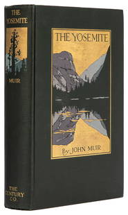
Sold2023 MUIR, John (1838-1914). The Yosemite. New York: The Century...MUIR, John (1838-1914). The Yosemite. New York: The Century Co., 1912. 8vo. 32 full-page plates from photographs, 3 folding maps. Original pictorial dark green cloth, top edge gilt (small spot of ghosSee Sold Price
Sold2023First Edition of Muir's The Yosemite w/ mapsHeading: Author: Muir, John Title: The Yosemite Place Published: New York Publisher:The Century Co. Date Published: 1912 Description: 284 pp. Illustrated from photographs, plus 3 fSee Sold Price
Sold2017John Muir The Yosemite First EditionHeading: Author: Muir, John Title: The Yosemite Place Published: New York Publisher:Century Co. Date Published: 1912 Description: x, 284. 32 full page plates from photograpSee Sold Price
Sold2023CHINA JEFFERSON (LOUISE E.) China. A Friendship Map, New York, Friendship Press, Inc., 1948CHINA JEFFERSON (LOUISE E.) China. A Friendship Map, pictorial colour printed map, numerous illustrations of famous sites, industries, and views, six portraits (including Sun Yat-sen, Chiang Kai-shekSee Sold Price
Sold201510 Maps: New York street grid, views, US, MD[New York/Maryland/US] 10 Maps. 8 1/8 x 9 3/4 in. to 17 7/8 x 27 1/2 in. Sold with all faults. ++ MAP OF THE CITY OF NEW-YORK 1852. Folding map from an annual edition of Valentine’s Manual. ++ PARTSee Sold Price
Sold2019Large map, New York City's UWS, 1879Large map, New York City's UWS, 1879, "West End Plateau of New York" by Herman K. Viele, City Surveyor, printed by Johnson & Pratt, New York, 1879, framed under acrylic, with 25-page booklet in pocketSee Sold Price
Sold2017Antique Map: New York & Area - EngravingPensylvania Nova Jersey et Nova York cum Regionibus Ad Fluvium Delaware In America Sitis, Nova Delinatione ob oculos posita...Tobias Conrad Lotter (1717 - 1777). Engraved map with hand-color in part.See Sold Price
Sold2023The Lost Titanic Oringinal April 17 1912 New York American Newspaper Pages 3 Thur 10 - On page 7 IsOringinal April 17 1912 New York American Newspaper Pages 3 thur 10 - On page 7 is a Piture of the Captain E J Smith and his Officers. The Headline across the top of pages 6 and 7 reads " Anixious RelSee Sold Price
Sold20231912 NEW YORK IN THE WAR OF THE REBELLION 1861-1865 4 VOLUMES antiqueNEW YORK IN THE WAR OF THE REBELLION 4 VOLUMES (of 6, incomplete set) Albany; 1912 Third edition Size 8 by 11" Hard cover. Publisher's blue cloth with gilt title on the spines Total 3616 pages very goSee Sold Price
Sold2023M. Dripps 1860 Map New York City County & Vacinity By M. DrippsM. Dripps 1860 Map New York City County & Vacinity By M. Dripps 22.5" x 30"See Sold Price
Sold20241912 "New York 94301" Porcelain License Plate 1912 "New York 94301" Porcelain License PlateSee Sold Price
Sold2016Map, New York Harbor, G. Mathiot, 1886This map depicts the New York Bay and Harbor area as of 1886, printed with color and with as accurate as possible scaling and measurements of depth given the time period. The top left denotes the yearSee Sold Price
Sold2018Antique Wall Map NEW YORK POSTAL ROUTES 1898 MailDetails: This large hanging wall map of postal routes in the state of New York was created by topographer A. von Haake, and printed by "Julius Bien & Co., Photo. Lith." Dated March, 1, 1898, this mapSee Sold Price
Sold2016Antique Map : New York, New Jersey - 1870Antique Map : New York, New Jersey, Pennsylvania, Ohio, Delaware, Maryland , Virginia & West Virginia - 1870 Size : 15.5" x 18.5"See Sold Price
Sold2019Pan Am Pan American Flight Map New York CaribbeanTitle/Content of Map: Pan Am Pan American Flight Map New York Caribbean Date: c1960 Cartographer: ANONYMOUS Publisher: PAN AM AIRLINES Size: 24.25Height - 14.5Width Seat-back pocket map for flights toSee Sold Price
7 hrs LeftJasper52NEW YORK CITY antique town city map plan. Manhattan Brooklyn Jersey. SDUK 1844US$600
7 hrs LeftJasper52An accurate Map of New York, in North America… Universal Magazine 1780 oldUS$550
7 hrs LeftJasper52Johnson's New York & Adjacent Cities. Brooklyn Manhattan Jersey City 1866 mapUS$300
23 hrs LeftSwann Auction GalleriesSTANLEY WALTER GALLI (1912-2009) New York / United Air Lines. Circa 1960.US$600
23 hrs LeftSwann Auction GalleriesVARIOUS CARTOGRAPHERS Group of 10 lithographed folding maps and plans taken from various editions ofUS$375
23 hrs LeftSwann Auction GalleriesHENRY F. WALLING (1825-1889) Map of the City of New York and Its Vicinity. 1866.US$1,900
3 days LeftPUBLIC SALE1929 Insurance Maps of Brooklyn NY Atlas, Sanborn Hardcover FolioUS$125(2 bids)
3 days LeftLink Auction GalleriesMorris M. Shulman, New York (1912-1978), Untitled, 1955, casein on paper on boardUS$250
4 days LeftGrace Auction & Estate Gallery LLCPainting by Steven C. Howard, Chatham Light 1949 Lyme ConnecticutUS$50(1 bid)
20 hrs LeftEldred'sROBERT NOEL BLAIR (New York, 1912-2002), "Riders in the Rocks", 1939., Mixed media on cream woveUS$300
Oct 12JM Hobby Supply and Railroad Artifact Auctions1882 Indiana Bloomington and Western Railway MapUS$30


![10 Maps: New York street grid, views, US, MD: [New York/Maryland/US] 10 Maps. 8 1/8 x 9 3/4 in. to 17 7/8 x 27 1/2 in. Sold with all faults. ++ MAP OF THE CITY OF NEW-YORK 1852. Folding map from an annual edition of Valentine’s Manual. ++ PART](https://p1.liveauctioneers.com/179/82189/42599761_1_x.jpg?height=310&quality=70&version=1447864785)


