Sold20221902 Map of Hunterdon County NJ Irving C HicksIrving Hicks Publisher, Pugh & Downing Engineers. Approx 42" x 50 1/2"See Sold Price
Sold2019Vintage Road Maps (14)Including 1980-1981 New Jersey map & guide; (3) Somerset & Hunterdon Counties New Jersey map; Burlington Bridges Area Road map; Northern Hunterdon County, NJ map; Sunoco New York map; Texaco Florida,See Sold Price
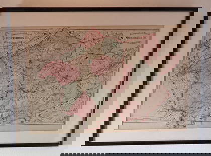
Sold2020Road Map of Hunterdon County New JerseyRoad map of Hunterdon County New Jersey. Published and distributed by Hunterdon County Democrat, Flemington, NJ, Delaware Valley News, Frenchtown, NJ. On a blue card stock type paper. Has some loss inSee Sold Price
Sold2022GROUP LOT OF VINTAGE PAPER GOODSINCLUDING: 19TH/20TH C. CORRESPONDENCE, PHOTOS, TRADE CARDS, NJ HISTORY/DIRECTORY, REPRINT OF SUSSEX COUNTY, NJ MAP AND MORE Terms: Hartzell's Auction Gallery will handle most of the shipping in-houseSee Sold Price
Sold2022Topographical Atlas of Bergen County NJ (US) 1876Topographical Illustrated, Historical Descriptive, A.H. Walker, Published by C.C. Pease, Successor to A.H. Walker. Color maps, home sites, business locations in fold-out pages. Cover in green with blaSee Sold Price
Sold2020NJ TOPOGRAPHICAL MAP CENTRAL HIGHLANDS MORRIS & SUSSEXNJ TOPOGRAPHICAL MAP CENTRAL HIGHLANDS MORRIS & SUSSEX COUNTIES 1888 JOHN C. SMOCK STATE GEOLOGIST, OVERALL DIMENSIONS INCLUDING FRAME 31 3/4 IN X 42 3/4 INSee Sold Price
Sold201719th c. Bergen County Hackensack N.J. CupboardEarly 19th c. Bergen County Hackensack N.J. serving cupboard. Central long drawer, flanked by two drawers, over two doors. Classic Bergen County matchstick design. Bennington knobs. 48 1/2" x 17" x 47See Sold Price
Sold20161856 MAP OF NEWTONTHOMAS HUGHES - ORIGINAL MAP OF NEWTON, NEW JERSEY SUSSEX COUNTY NJ 46"X34"See Sold Price
Sold2022Surrey.- Greenwood (C. & J.) Map of the County of Surrey from an actual Survey, made in the yearsNO RESERVE Surrey.- Greenwood (C. & J.) Map of the County of Surrey from an actual Survey, made in the years 1822 and 1823..., large county map, with vignette of Kew Palace, compass rose, calligraphicSee Sold Price
Sold20201862 Colton Map of the United States -- Colton's NewTitle/Content of Map: 1862 Colton Map of the United States -- Colton's New Railroad & County Map of the United States the Canadas &c. Cartographer: J Colton Year/Place: 1862, New York Size: 33.1 X 39See Sold Price
Sold2016[James Wilson]. Manuscript Plat Map of Luzerne C[James Wilson]. Manuscript Plat Map of Luzerne County, Pennsylvania with Autograph Endorsement SignedSee Sold Price
Sold2023Original Vintage c. 1930s Dutch Airline Travel PosterWijga, Jan 1902 - 1978 KNILM - Complete Map of the Airlines Letterpress Print ca. 1938 22.4 x 29.9 in. (57 x 76 cm) Printer: Herdruk E. Fuhri & Co., S'Baia Condition Details: (B+) small tears, creasesSee Sold Price
Sold2023Antique 19th C. Map of East Los Angeles CountyAntique 19th Century panoramic map of East Los Angeles County, California, depicting a bird's-eye view from Los Angeles River looking towards the Sierra Madre Mountains. Printed by H.S. Crocker & Co.,See Sold Price
Sold2024Maps of All Texas Counties, 1885-1927Heading: (Texas) Author: Title: Maps of All Texas Counties (Latest Edition) Place Published: Tulsa, OK Publisher:Wolf & Bennet Date Published: c. 1927 Description: Approximately 25See Sold Price
Sold2022Real estate in Cow Hollow & Marina, 1863Heading: -1863 Author: Potter, George Clinton Title: Map of the Ricket Tract, Surveyed by Geo. C. Potter, City & County Surveyor, to be sold on Wednesday, March 4th, 1863 at Platt's Music Hall by JeroSee Sold Price
Sold2023Important lot 18th c documents from Hurley New York, many signatures of the significant families inImportant lot 18th c documents from Hurley New York, many signatures of the significant families in Ulster County, also hand drawn maps, stamped seals and small box of fragments of manuscripts and docSee Sold Price
Sold2017ATLAS OF FREDERICK COUNTY MARYLAND. 1873.[Atlas] ATLAS OF FREDERICK COUNTY MARYLAND. From actual Surveys by and under the direction of D. J. Lake, C. E. Philadelphia: C. O. Titus & Co., 1873. 33 pages of local maps + folding map of MarylandSee Sold Price
Sold2023Folk Art Carving of an Angel with BirdsAttributed to Albert Zahn (1894-1953). Bailey's Harbor, Door County, Wisconsin. 20th C. Painted white, black, and red. 44"h Provenance: Property from a Private Princeton, NJ CollectionSee Sold Price
2022Blaeu, Johannes (Netherlands, 1596-1673) "The New World Map" Double Hemisphere World Map C. 1664Nova et Accuratissima Totius Terrarum Orbis Tabula Translated "The New World Map", Hand Colored w/ Elaborately Decorated Spandrels.   Sight View 16" x 21-1/2", Overall View 21" x 25-1/2"See Sold Price
Sold2020Japanese 6-Panel Screen Map, c. 19th CenturyA Japanese hand painted screen possibly depicting a map of bay regions in Japan. The piece is presented predominantly in shades of blue and brown with vibrant gilt detailing. The screen features six pSee Sold Price
Sold2021Miniature Dove Pair with Chicks, Allen J. KingMiniature Dove Pair with Chicks Allen J. King (1878-1963) North Scituate, RI, c. 1940 4 3/4 in. tall An rare pair with two young in a nest. Signed by the maker on the branch. Original paint with minimSee Sold Price
Sold2021Miniature Woodcock Pair with Chicks, Allen J. KingMiniature Woodcock Pair with Chicks Allen J. King (1878-1963) North Scituate, RI, c. 1940 1 3/4 in. tall An exceptional timberdoodle pair with two chicks on a signed burl base. Original paint with minSee Sold Price
Sold2022Mid 18th C. O / C Painting "two peacocks with their chicks, two hens and their chicks, one roosterMid 18th C. O / C Painting "two peacocks with their chicks, two hens and their chicks, one rooster and one owl in a landscape" / attributed to: Giovanni Crivelli / the painting is out of the Bo and PaSee Sold Price
3 days LeftFreeman's | Hindman[HARDY, Thomas]. -- WINDLE, C.A. The Wessex of Thomas Hardy. Edmund H. New, illustrator. 1902.US$200
4 days LeftWorthington GalleriesFirst Edition Hand-colored Map THE NORTH RIDING OF YORKSHIRE by Robert MordenUS$50
BonhamsSCOTTISH NATIONAL ANTARCTIC EXPEDITION, 1902-1904 [BROWN (ROBERT NEAL RUDMOSE, etc.) The Voyage ...£500
4 days LeftEarly American History Auctionsc 1730 Hand-Colored Colonial Era Map of the Americas, California shown as an Island, Matted + FramedUS$500(1 bid)
7 days LeftQuittenbaum Kunstauktionen GmbHVilmos Zsolnay, Pécs, Vase with snails, c. 1902€4,000
7 days LeftQuittenbaum Kunstauktionen GmbHLoetz, Klášterský Mlýn, 'Argus'-Vase, c. 1902€2,200
Jun 14DuMouchellesWilliam H. Gamble (American, B. 1863) Hand Colored Engraving, Ca. 1863, "County Map of Michigan AndUS$50(1 bid)


![[James Wilson]. Manuscript Plat Map of Luzerne C: [James Wilson]. Manuscript Plat Map of Luzerne County, Pennsylvania with Autograph Endorsement Signed](https://p1.liveauctioneers.com/906/86611/44529635_1_x.jpg?height=310&quality=70&version=1458833472)


![ATLAS OF FREDERICK COUNTY MARYLAND. 1873.: [Atlas] ATLAS OF FREDERICK COUNTY MARYLAND. From actual Surveys by and under the direction of D. J. Lake, C. E. Philadelphia: C. O. Titus & Co., 1873. 33 pages of local maps + folding map of Maryland](https://p1.liveauctioneers.com/179/104231/53361903_1_x.jpg?height=310&quality=70&version=1495213319)


![[HARDY, Thomas]. -- WINDLE, C.A. The Wessex of Thomas Hardy. Edmund H. New, illustrator. 1902. (1 of 3)](https://p1.liveauctioneers.com/197/329395/177650387_1_x.jpg?height=282&quality=70&version=1715364962)


